
| MOUNTAIN GROVE MEMORIAL MOUNTAIN GROVE MO |
| |
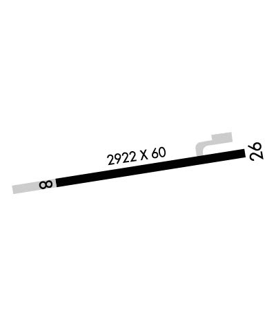
| Lat: N 3707.3 Long: W 09218.6 Elev: 1476 Var: -01 Longest Runway: 2922 | ||
| CTAF: 122.9 | ||
| ||||||||||||||||||||||||||||||||
| ||||||||||||||||||||||||||||||||
| Rwy | Rwy | |||||||
| 2922x60 | 2922' | 2922x60 | 2922' | |||||
| Runway ID | Single Wheel | Double Wheel | Double Tandem Wheel | Dual Double Wheel |
| 08/26 | N/A | N/A | N/A | N/A |
| These numbers are Advisory and are not limits. The Airport Manager should have more accurate Weight Limits | ||||
 Airport Diagram might not be current. | |
| Facility Name: | MOUNTAIN GROVE MEML |
| City Name: | MOUNTAIN GROVE |
| County: | WRIGHT |
| State abbrev: | MO |
| State Name: | MISSOURI |
| Ownership: | PUBLICLY OWNED |
| Use: | OPEN TO THE PUBLIC |
| Owner's Name: | CITY OF MOUNTAIN GROVE |
| Address: | 100 E. STATE, P.O. BOX 351 |
| MOUNTAIN GROVE, MO 65711 | |
| Owner's Phone: | 417-926-4162 |
| Manager's Name: | DAVID RICHARDSON |
| Address: | 100 E. STATE STREET |
| MOUNTAIN GROVE, MO 65711 | |
| Phone: | (417) 926-4162 |
| FAA Region: | CENTRAL |
| FAA Field Office: | NONE |
| Date | Sunrise | Sunset |
|---|---|---|
| 06/08/26 Monday | 5:49 | 20:28 |
| 06/09/26 Tuesday | 5:49 | 20:28 |
| 06/10/26 Wednesday | 5:49 | 20:29 |
| 06/11/26 Thursday | 5:49 | 20:29 |
| 06/12/26 Friday | 5:49 | 20:30 |
| 06/13/26 Saturday | 5:49 | 20:30 |
| 06/14/26 Sunday | 5:49 | 20:30 |
| 06/15/26 Monday | 5:49 | 20:31 |
| 06/16/26 Tuesday | 5:49 | 20:31 |
| 06/17/26 Wednesday | 5:49 | 20:31 |
| 06/18/26 Thursday | 5:49 | 20:32 |
| 06/19/26 Friday | 5:49 | 20:32 |
| 06/20/26 Saturday | 5:49 | 20:32 |
| 06/21/26 Sunday | 5:49 | 20:33 |
| Airport Attendance Schedule | CONTINUOUS |
| Airport Status | OPERATIONAL (This Status can change at any time - please check NOTAMS) |
| Airport Lighting Schedule | ACTVT REIL RWY 08 & 26; MIRL RWY 08/26 - CTAF. |
| Airport Storage Available | Tie Downs |
| Extra Services Available | Crop Dusting, Flight Instruction, Annual Surveying |
| Wind Indicator | YES - (lighted) |
| Control Tower | NO |
| CTAF Frequency | 122.900 |
| Unicom Frequency | |
| Rotating Beacon Color | WG; ROTG BCN ON WATER TOWER EAST OF ARPT. |
| Segmented Circle | YES |
| Landing Fee | NO |
| Airport Inspected | STATE - performed by STATE AERONAUTICAL PERSONNEL |
| Inspection Date | 08/27/2025 |
| Type of Fuel Available | Grade 100LL |
| Airframe Repair Service | NONE |
| Power Plant Repair Service | NONE |
| Latitude | N3707.3 |
| Longitude | W09218.6 (ESTIMATED) |
| Arpt Elevation | 1476ft (SURVEYED) |
| Magnetic Variation | 01E |
| 3 miles SW | of MOUNTAIN GROVE |
| Traffic Pattern Altitude | |
| Sectional Chart | KANSAS CITY |
| Operations (Reported) | Yearly | Avg. Daily |
|---|---|---|
| General Aviation Transient | 0 | 0 |
| General Aviation Local | 0 | 0 |
| Air Taxi | 0 | 0 |
| Commerical | 0 | 0 |
| Commuter | 0 | 0 |
| Military | 0 | 0 |
| Aircraft based on Field | |
|---|---|
| General Aviation Singles | 0 |
| General Aviation Multi | 0 |
| Jet Aircraft | 0 |
| General Aviation Helicopters | 0 |
| Military Aircraft | 0 |
| Gliders | 0 |
| Ultralights | 0; ULTRALIGHT ACTVTY ON & INVOF ARPT. |
| FSS on field | NO |
| FSS tie-in | COLUMBIA |
| FSS Phone | 1-800-WX-BRIEF |
| Who issues Notams | COU |
| Notam D service at airport | YES |
| ARTCC Name | KANSAS CITY |
| Airport Certification | |
| Aircraft Rescue & Firefighting Index | None |
| Airport of Entry | No |
| Custom Landing Rights | No |
| Joint Civil/Military | No |
| Military Landing rights | No |
| NATIONAL PLAN OF INTEGRATED AIRPORT SYSTEMS (NPIAS) |
| CROP DUSTING ACFT ON & INVOF ARPT. |
| FOR CD CTC KANSAS CITY ARTCC AT 913-254-8508. |
Airport Communications & Frequencies:
| |||||||
| Runway: 08 | Runway: 26 | ||
| Mag heading: | 80° | Mag heading: | 260° |
| Rwy Slope: | .82% Up | Rwy Slope: | -.82% Down |
| Approach: | Approach: | ||
| Pattern: | Left Traffic | Pattern: | Left Traffic |
| Markings: | NONPRECISION INSTRUMENT | Markings: | NONPRECISION INSTRUMENT |
| Marking Condition: | GOOD | Marking Condition: | GOOD |
| Arresting Dev: | Arresting Dev: | ||
| Lat & Long: | N3707.2 W09218.9 | Lat. & Long.: | N3707.3 W09218.3 |
| Elev: | 1452.2 ft. MSL | Elev: | 1476.2 ft. MSL |
| TCH: | 43 ft. AGL | TCH: | 43 ft. AGL |
| Visual Glide Path: | 4.00 degrees | Visual Glide Path: | 4.00 degrees |
| Displaced Threshold: | No | Displaced Threshold: | No |
| Touchdown Zone: | YES | Touchdown Zone: | YES |
| Touchdown Elev.: | 1476.4 feet | Touchdown Elev.: | 1476.4 feet |
| Visual Glide Slope: | 2-Light PAPI on LEFT side of Runway | Visual Glide Slope: | 2-Light PAPI on LEFT side of Runway |
| RVR Equipment: | RVR Equipment: | ||
| RVV Equipment: | NO | RVV Equipment: | NO |
| Approach Lights: | Approach Lights: | ||
| REIL: | YES | REIL: | YES |
| Centerline Lights: | NO | Centerline Lights: | NO |
| Touchdown lights: | NO | Touchdown lights: | NO |
| Runway Category: | Runway with a Non-precision Approach | Runway Category: | Runway with a Non-precision Approach |
| Declared Distances: | Declared Distances: | ||
| Obstructions: | TREES | Obstructions: | ROAD |
| Marked: | NOT Marked/Lighted | Marked: | NOT Marked/Lighted |
| Clearance slope: | 2:1 | Clearance slope: | 5:1 |
| Obstruction height: | 51 feet AGL | Obstruction height: | 15 feet AGL |
| Dist. from runway: | 307 feet | Dist. from runway: | 285 feet |
| Centerline offset: | 150 right of centerline | Centerline offset: | 250 feet right of centerline |
| Comments: | RWY 8 HAS 18-54 FT TREES 0-200 FT FROM RWY END 150-228 FT RIGHT AND 195-200 FT LEFT. | Comments: |
Thanks for using FltPlan.com
all rights reserved © 1999-2026 by Flight Plan LLC
