
| PAROWAN PAROWAN UT |
| |
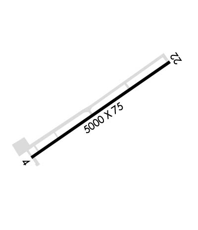
| Lat: N 3751.6 Long: W 11249.0 Elev: 5930 Var: -14 Longest Runway: 5000 | ||
| CTAF: 122.8 | ||
| ||||||
|
| Rwy | Rwy | |||||||
| 5000x75 | 5000' | 5000x75 | 5000' | |||||
| Runway ID | Single Wheel | Double Wheel | Double Tandem Wheel | Dual Double Wheel |
| 04/22 | 12,500 | N/A | N/A | N/A |
| These numbers are Advisory and are not limits. The Airport Manager should have more accurate Weight Limits | ||||
| FltPlan does not have IFR approach charts available for K1L9. |
 Airport Diagram might not be current. | |
| Facility Name: | PAROWAN |
| City Name: | PAROWAN |
| County: | IRON |
| State abbrev: | UT |
| State Name: | UTAH |
| Ownership: | PUBLICLY OWNED |
| Use: | OPEN TO THE PUBLIC |
| Owner's Name: | CITY OF PAROWAN |
| Address: | 35 E 100N, PO BOX 576, PO BOX 576 |
| PAROWAN, UT 84761 | |
| Owner's Phone: | 435-477-3331 |
| Manager's Name: | DAVID NORWOOD |
| Address: | P.O. BOX 576 |
| PAROWAN, UT 84761 | |
| Phone: | (435) 477-8911 |
| FAA Region: | NORTHWEST MOUNTAIN |
| FAA Field Office: | DEN |
| Date | Sunrise | Sunset |
|---|---|---|
| 09/24/21 Friday | 7:21 | 19:25 |
| 09/25/21 Saturday | 7:21 | 19:24 |
| 09/26/21 Sunday | 7:22 | 19:22 |
| 09/27/21 Monday | 7:23 | 19:21 |
| 09/28/21 Tuesday | 7:24 | 19:19 |
| 09/29/21 Wednesday | 7:25 | 19:18 |
| 09/30/21 Thursday | 7:26 | 19:16 |
| 10/01/21 Friday | 7:27 | 19:15 |
| 10/02/21 Saturday | 7:28 | 19:13 |
| 10/03/21 Sunday | 7:28 | 19:11 |
| 10/04/21 Monday | 7:29 | 19:10 |
| 10/05/21 Tuesday | 7:30 | 19:08 |
| 10/06/21 Wednesday | 7:31 | 19:07 |
| 10/07/21 Thursday | 7:32 | 19:05 |
| Airport Attendance Schedule | 7 Days A Week 0800-1700 |
| Airport Status | OPERATIONAL (This Status can change at any time - please check NOTAMS) |
| Airport Lighting Schedule | ACTVT MIRL RY 04/22, PAPI AND REIL RYS 04 AND 22 - CTAF. |
| Airport Storage Available | Tie Downs |
| Extra Services Available | NONE |
| Wind Indicator | YES - (lighted) |
| Control Tower | NO |
| CTAF Frequency | 122.800 |
| Unicom Frequency | 122.800 |
| Rotating Beacon Color | CLEAR-GREEN (Light Land Airport) |
| Segmented Circle | YES |
| Landing Fee | NO |
| Airport Inspected | STATE - performed by STATE AERONAUTICAL PERSONNEL |
| Inspection Date | 07/10/2019 |
| Type of Fuel Available | Grade 100LL, JET A (freeze point -40C) |
| Airframe Repair Service | MAJOR |
| Power Plant Repair Service | MINOR |
| Latitude | N3751.6 |
| Longitude | W11249.0 (ESTIMATED) |
| Arpt Elevation | 5930ft (ESTIMATED) |
| Magnetic Variation | 14E |
| 1 miles NE | of PAROWAN |
| Traffic Pattern Altitude | |
| Sectional Chart | LAS VEGAS |
| Operations (Reported) | Yearly | Avg. Daily |
|---|---|---|
| General Aviation Transient | 8200 | 22 |
| General Aviation Local | 11250 | 31 |
| Air Taxi | 50 | 0 |
| Commerical | 0 | 0 |
| Commuter | 0 | 0 |
| Military | 0 | 0 |
| Aircraft based on Field | |
|---|---|
| General Aviation Singles | 10 |
| General Aviation Multi | 1 |
| Jet Aircraft | 0 |
| General Aviation Helicopters | 1 |
| Military Aircraft | 0 |
| Gliders | 0 |
| Ultralights | 0 |
| FSS on field | NO |
| FSS tie-in | CEDAR CITY |
| FSS Phone | 1-800-WX-BRIEF |
| Who issues Notams | CDC |
| Notam D service at airport | YES |
| ARTCC Name | SALT LAKE CITY |
| Airport Certification | |
| Aircraft Rescue & Firefighting Index | None |
| Airport of Entry | No |
| Custom Landing Rights | No |
| Joint Civil/Military | No |
| Military Landing rights | YES |
| NATIONAL PLAN OF INTEGRATED AIRPORT SYSTEMS (NPIAS) |
| PRAIRIE DOG MOUNDS AND HOLES ON RWY EDGES AND TWY. |
| FOR CD CTC SALT LAKE ARTCC AT 801-320-2568. |
| Runway: 04 | Runway: 22 | ||
| Mag heading: | 39° | Mag heading: | 219° |
| Rwy Slope: | -1.26% Down | Rwy Slope: | 1.26% Up |
| Approach: | Approach: | ||
| Pattern: | Left Traffic | Pattern: | Right Traffic |
| Markings: | NONPRECISION INSTRUMENT | Markings: | NONPRECISION INSTRUMENT |
| Marking Condition: | FAIR | Marking Condition: | FAIR |
| Arresting Dev: | Arresting Dev: | ||
| Lat & Long: | N3751.3 W11249.4 | Lat. & Long.: | N3751.8 W11248.5 |
| Elev: | 5926.0 ft. MSL | Elev: | 5863.0 ft. MSL |
| TCH: | 40 ft. AGL | TCH: | 40 ft. AGL |
| Visual Glide Path: | 3.00 degrees | Visual Glide Path: | 3.00 degrees |
| Displaced Threshold: | No | Displaced Threshold: | No |
| Touchdown Zone: | NO | Touchdown Zone: | NO |
| Touchdown Elev.: | Touchdown Elev.: | ||
| Visual Glide Slope: | 2-Light PAPI on LEFT side of Runway | Visual Glide Slope: | 2-Light PAPI on LEFT side of Runway |
| RVR Equipment: | RVR Equipment: | ||
| RVV Equipment: | NO | RVV Equipment: | NO |
| Approach Lights: | Approach Lights: | ||
| REIL: | YES | REIL: | YES |
| Centerline Lights: | NO | Centerline Lights: | NO |
| Touchdown lights: | NO | Touchdown lights: | NO |
| Runway Category: | Runway with a Visual Approach | Runway Category: | Runway with a Visual Approach |
| Declared Distances: | Declared Distances: |
Thanks for using FltPlan.com
all rights reserved © 1999-2021 by Flight Plan LLC
