
| DAVID JAY PERRY GOLDSBY OK |
| |
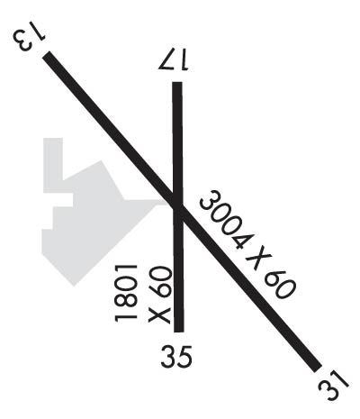
| Lat: N 3509.3 Long: W 09728.2 Elev: 1169 Var: -06 Longest Runway: 3004 | ||
| CTAF: 122.7 | ||
| ||||||||||||||||||||||||||||||||||||||||||||
| ||||||||||||||||||||||||||||||||||||||||||||
| Rwy | Rwy | |||||||
| 3004x60 | 3004' | 3004x60 | 3004' | |||||
| 1801x60 | 1801' | 1801x60 | 1801' | |||||
| Runway ID | Single Wheel | Double Wheel | Double Tandem Wheel | Dual Double Wheel |
| 13/31 | 30,000 | N/A | N/A | N/A |
| 17/35 | 4,000 | N/A | N/A | N/A |
| These numbers are Advisory and are not limits. The Airport Manager should have more accurate Weight Limits | ||||
 Airport Diagram might not be current. | |
| Facility Name: | DAVID JAY PERRY |
| City Name: | GOLDSBY |
| County: | MC CLAIN |
| State abbrev: | OK |
| State Name: | OKLAHOMA |
| Ownership: | PUBLICLY OWNED |
| Use: | OPEN TO THE PUBLIC |
| Owner's Name: | TOWN OF GOLDSBY |
| Address: | 100 E. CENTER ROAD |
| GOLDSBY, OK 73093 | |
| Owner's Phone: | 405-288-6675 |
| Manager's Name: | RONNY NELSON; PUBLIC WORKS DIRECTOR |
| Address: | 351 DJP MEMORIAL BLVD., 100 E. CENTER ROAD |
| GOLDSBY, OK 73093 | |
| Phone: | 405-570-8399 |
| FAA Region: | SOUTHWEST |
| FAA Field Office: | AOK |
| Date | Sunrise | Sunset |
|---|---|---|
| 09/24/21 Friday | 7:19 | 19:24 |
| 09/25/21 Saturday | 7:20 | 19:23 |
| 09/26/21 Sunday | 7:21 | 19:21 |
| 09/27/21 Monday | 7:21 | 19:20 |
| 09/28/21 Tuesday | 7:22 | 19:18 |
| 09/29/21 Wednesday | 7:23 | 19:17 |
| 09/30/21 Thursday | 7:24 | 19:15 |
| 10/01/21 Friday | 7:24 | 19:14 |
| 10/02/21 Saturday | 7:25 | 19:13 |
| 10/03/21 Sunday | 7:26 | 19:11 |
| 10/04/21 Monday | 7:27 | 19:10 |
| 10/05/21 Tuesday | 7:28 | 19:08 |
| 10/06/21 Wednesday | 7:28 | 19:07 |
| 10/07/21 Thursday | 7:29 | 19:06 |
| Airport Attendance Schedule | MON-FRI 0800-1700 |
| Airport Status | OPERATIONAL (This Status can change at any time - please check NOTAMS) |
| Airport Lighting Schedule | ACTVT MIRL RY 13/31 DUSK-DAWN - CTAF. |
| Airport Storage Available | Tie Downs |
| Extra Services Available | Flight Instruction |
| Wind Indicator | YES - (lighted) |
| Control Tower | NO |
| CTAF Frequency | 122.700 |
| Unicom Frequency | 122.700 |
| Rotating Beacon Color | CLEAR-GREEN (Light Land Airport) |
| Segmented Circle | YES |
| Landing Fee | NO |
| Airport Inspected | STATE - performed by STATE AERONAUTICAL PERSONNEL |
| Inspection Date | 05/08/2020 |
| Type of Fuel Available | Grade 100LL; -1024 HOUR AUTOMATED FUEL SERVICING SYSTEM. |
| Airframe Repair Service | NONE |
| Power Plant Repair Service | NONE |
| Latitude | N3509.3 |
| Longitude | W09728.2 (ESTIMATED) |
| Arpt Elevation | 1168ft (SURVEYED) |
| Magnetic Variation | 06E |
| 1 miles NE | of GOLDSBY |
| Traffic Pattern Altitude | |
| Sectional Chart | DALLAS-FT WORTH |
| Operations (Reported) | Yearly | Avg. Daily |
|---|---|---|
| General Aviation Transient | 5000 | 14 |
| General Aviation Local | 10000 | 27 |
| Air Taxi | 0 | 0 |
| Commerical | 0 | 0 |
| Commuter | 0 | 0 |
| Military | 0 | 0 |
| Aircraft based on Field | |
|---|---|
| General Aviation Singles | 45 |
| General Aviation Multi | 0 |
| Jet Aircraft | 0 |
| General Aviation Helicopters | 0 |
| Military Aircraft | 0 |
| Gliders | 0 |
| Ultralights | 0 |
| FSS on field | NO |
| FSS tie-in | MC ALESTER |
| FSS Phone | 1-800-WX-BRIEF |
| Who issues Notams | MLC |
| Notam D service at airport | YES |
| ARTCC Name | FORT WORTH |
| Airport Certification | |
| Aircraft Rescue & Firefighting Index | None |
| Airport of Entry | No |
| Custom Landing Rights | No |
| Joint Civil/Military | No |
| Military Landing rights | YES |
| NATIONAL PLAN OF INTEGRATED AIRPORT SYSTEMS (NPIAS) |
| GRANT AGREEMENTS UNDER FAAP/ADAP/AIP |
| SURPLUS PROPERTY AGREEMENT UNDER REGULATION 16-WAA |
| ASSURANCES PURSUANT TO TITLE VI, CIVIL RIGHTS ACT OF 1964 |
| INTENSIVE STUDENT TRNG DALGT HRS. |
| ULTRALIGHT ACTIVITY ON & INVOF ARPT. |
| COYOTES ON & INVOF RY. |
| FOR CD CTC OKE CITY APCH AT 405-681-5683. |
Airport Communications & Frequencies:
| ||||||||||||||
| Runway: 13 | Runway: 31 | ||
| Mag heading: | 130° | Mag heading: | 310° |
| Rwy Slope: | -.35% Down | Rwy Slope: | .35% Up |
| Approach: | Approach: | ||
| Pattern: | Left Traffic | Pattern: | Left Traffic |
| Markings: | BASIC | Markings: | NONPRECISION INSTRUMENT |
| Marking Condition: | GOOD | Marking Condition: | GOOD |
| Arresting Dev: | Arresting Dev: | ||
| Lat & Long: | N3509.5 W09728.4 | Lat. & Long.: | N3509.1 W09728.0 |
| Elev: | 1167.0 ft. MSL | Elev: | 1156.6 ft. MSL |
| TCH: | TCH: | ||
| Visual Glide Path: | Visual Glide Path: | ||
| Displaced Threshold: | No | Displaced Threshold: | No |
| Touchdown Zone: | YES | Touchdown Zone: | YES |
| Touchdown Elev.: | 1167.0 feet | Touchdown Elev.: | 1167.0 feet |
| Visual Glide Slope: | Visual Glide Slope: | ||
| RVR Equipment: | RVR Equipment: | ||
| RVV Equipment: | NO | RVV Equipment: | NO |
| Approach Lights: | Approach Lights: | ||
| REIL: | NO | REIL: | NO |
| Centerline Lights: | NO | Centerline Lights: | NO |
| Touchdown lights: | NO | Touchdown lights: | NO |
| Runway Category: | Runway with a Visual Approach | Runway Category: | Runway with a Non-precision Approach having visibility minimums greater than 3/4 mile |
| Declared Distances: | Declared Distances: | ||
| Obstructions: | TREES | Obstructions: | TREES |
| Marked: | NOT Marked/Lighted | Marked: | NOT Marked/Lighted |
| Clearance slope: | 15:1 | Clearance slope: | 15:1 |
| Obstruction height: | 69 feet AGL | Obstruction height: | 35 feet AGL |
| Dist. from runway: | 1300 feet | Dist. from runway: | 725 feet |
| Centerline offset: | 192 right of centerline | Centerline offset: | 230 feet left of centerline |
| Comments: | Comments: |
| Runway: 17 | Runway: 35 | ||
| Mag heading: | 175° | Mag heading: | 355° |
| Rwy Slope: | -.44% Down | Rwy Slope: | .44% Up |
| Approach: | Approach: | ||
| Pattern: | Left Traffic | Pattern: | Left Traffic |
| Markings: | BASIC | Markings: | BASIC |
| Marking Condition: | GOOD | Marking Condition: | GOOD |
| Arresting Dev: | Arresting Dev: | ||
| Lat & Long: | N3509.5 W09728.2 | Lat. & Long.: | N3509.2 W09728.2 |
| Elev: | 1168.8 ft. MSL | Elev: | 1160.8 ft. MSL |
| TCH: | TCH: | ||
| Visual Glide Path: | Visual Glide Path: | ||
| Displaced Threshold: | No | Displaced Threshold: | No |
| Touchdown Zone: | YES | Touchdown Zone: | YES |
| Touchdown Elev.: | 1168.8 feet | Touchdown Elev.: | 1168.8 feet |
| Visual Glide Slope: | Visual Glide Slope: | ||
| RVR Equipment: | RVR Equipment: | ||
| RVV Equipment: | NO | RVV Equipment: | NO |
| Approach Lights: | Approach Lights: | ||
| REIL: | NO | REIL: | NO |
| Centerline Lights: | NO | Centerline Lights: | NO |
| Touchdown lights: | NO | Touchdown lights: | NO |
| Runway Category: | Runway with a Visual Approach | Runway Category: | Runway with a Visual Approach |
| Declared Distances: | Declared Distances: | ||
| Obstructions: | TREES | Obstructions: | TREES |
| Marked: | NOT Marked/Lighted | Marked: | NOT Marked/Lighted |
| Clearance slope: | 16:1 | Clearance slope: | 16:1 |
| Obstruction height: | 35 feet AGL | Obstruction height: | 38 feet AGL |
| Dist. from runway: | 780 feet | Dist. from runway: | 823 feet |
| Centerline offset: | Centerline offset: | 138 feet right of centerline | |
| Comments: | Comments: |
Thanks for using FltPlan.com
all rights reserved © 1999-2021 by Flight Plan LLC
