
| MEDINA MUNI MEDINA OH |
| |
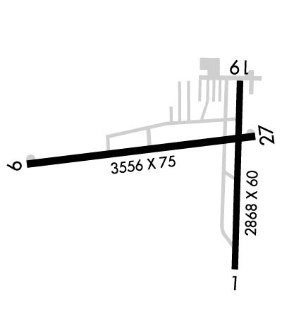
| Lat: N 4107.9 Long: W 08145.9 Elev: 1190 Var: +07 Longest Runway: 3556 | ||
| CTAF: 123.0 | ||
| ||||||
|
| Rwy | Rwy | |||||||
| 2868x60 | 2868' | 2868x60 | 2131' | |||||
| 3556x75 | 3556' | 3556x75 | 3556' | |||||
| Runway ID | Single Wheel | Double Wheel | Double Tandem Wheel | Dual Double Wheel |
| 01/19 | 25,000 | N/A | N/A | N/A |
| 09/27 | 30,000 | N/A | N/A | N/A |
| These numbers are Advisory and are not limits. The Airport Manager should have more accurate Weight Limits | ||||
 Airport Diagram might not be current. | |
| Facility Name: | MEDINA MUNI |
| City Name: | MEDINA |
| County: | MEDINA |
| State abbrev: | OH |
| State Name: | OHIO |
| Ownership: | PUBLICLY OWNED |
| Use: | OPEN TO THE PUBLIC |
| Owner's Name: | CITY OF MEDINA |
| Address: | PO BOX 703 |
| MEDINA, OH 44258-0703 | |
| Owner's Phone: | 330-725-8861 |
| Manager's Name: | GREG HUBER |
| Address: | PO BOX 703 |
| MEDINA, OH 44258-0703 | |
| Phone: | 330-239-1606 |
| FAA Region: | GREAT LAKES |
| FAA Field Office: | DET |
| Date | Sunrise | Sunset |
|---|---|---|
| 06/08/26 Monday | 5:55 | 20:58 |
| 06/09/26 Tuesday | 5:54 | 20:58 |
| 06/10/26 Wednesday | 5:54 | 20:59 |
| 06/11/26 Thursday | 5:54 | 20:59 |
| 06/12/26 Friday | 5:54 | 21:00 |
| 06/13/26 Saturday | 5:54 | 21:00 |
| 06/14/26 Sunday | 5:54 | 21:01 |
| 06/15/26 Monday | 5:54 | 21:01 |
| 06/16/26 Tuesday | 5:54 | 21:02 |
| 06/17/26 Wednesday | 5:54 | 21:02 |
| 06/18/26 Thursday | 5:54 | 21:02 |
| 06/19/26 Friday | 5:54 | 21:03 |
| 06/20/26 Saturday | 5:54 | 21:03 |
| 06/21/26 Sunday | 5:54 | 21:03 |
| Airport Attendance Schedule | APR-OCT 7 Days A Week 0800-2000, NOV-MAR 7 Days A Week 0800-1700 |
| Airport Status | OPERATIONAL (This Status can change at any time - please check NOTAMS) |
| Airport Lighting Schedule | ACTVT REIL RWY 27; PAPI RWY 01, 19, & 27; MIRL RWY 01/19 & 09/27 - CTAF. PAPI RWY 01, 19, & 27 OPR CONSLY DUSK-2200. |
| Airport Storage Available | Tie Downs, Hanger |
| Extra Services Available | Flight Instruction, Aircraft Rental, Annual Surveying |
| Wind Indicator | YES - (lighted) |
| Control Tower | NO |
| CTAF Frequency | 123.000 |
| Unicom Frequency | 123.000 |
| Rotating Beacon Color | WG |
| Segmented Circle | YES |
| Landing Fee | NO |
| Airport Inspected | STATE - performed by STATE AERONAUTICAL PERSONNEL |
| Inspection Date | 10/05/2023 |
| Type of Fuel Available | Grade 100LL, JET A; -10AVBL H24 SELF SER. |
| Airframe Repair Service | MAJOR |
| Power Plant Repair Service | MAJOR |
| Latitude | N4107.9 |
| Longitude | W08145.9 (ESTIMATED) |
| Arpt Elevation | 1189ft (SURVEYED) |
| Magnetic Variation | 07W |
| 4 miles E | of MEDINA |
| Traffic Pattern Altitude | |
| Sectional Chart | DETROIT |
| Operations (Reported) | Yearly | Avg. Daily |
|---|---|---|
| General Aviation Transient | 0 | 0 |
| General Aviation Local | 0 | 0 |
| Air Taxi | 0 | 0 |
| Commerical | 0 | 0 |
| Commuter | 0 | 0 |
| Military | 0 | 0 |
| Aircraft based on Field | |
|---|---|
| General Aviation Singles | 0 |
| General Aviation Multi | 0 |
| Jet Aircraft | 0 |
| General Aviation Helicopters | 0 |
| Military Aircraft | 0 |
| Gliders | 0 |
| Ultralights | 0 |
| FSS on field | NO |
| FSS tie-in | CLEVELAND |
| FSS Phone | 1-800-WX-BRIEF |
| Who issues Notams | CLE |
| Notam D service at airport | YES |
| ARTCC Name | CLEVELAND |
| Airport Certification | |
| Aircraft Rescue & Firefighting Index | None |
| Airport of Entry | No |
| Custom Landing Rights | No |
| Joint Civil/Military | No |
| Military Landing rights | No |
| NATIONAL PLAN OF INTEGRATED AIRPORT SYSTEMS (NPIAS) |
| GRANT AGREEMENTS UNDER FAAP/ADAP/AIP |
| ASSURANCES PURSUANT TO TITLE VI, CIVIL RIGHTS ACT OF 1964 |
| DEER, BIRDS, & OTR WILDLIFE ON & INVOF ARPT. |
| FOR CD CTC CLEVELAND APCH AT 216-352-2323. |
| NOISE SENSITIVE RESIDENTIAL AND LIVESTOCK AREAS INVOF ALL RWY ENDS. MNTN RWY HDG TIL RCHNG TPA. |
Airport Communications & Frequencies:
| ||||||||||||||
| Runway: 01 | Runway: 19 | ||
| Mag heading: | 8° | Mag heading: | 188° |
| Rwy Slope: | .69% Up | Rwy Slope: | -.69% Down |
| Approach: | Approach: | ||
| Pattern: | Left Traffic | Pattern: | Left Traffic |
| Markings: | BASIC | Markings: | BASIC |
| Marking Condition: | GOOD | Marking Condition: | GOOD |
| Arresting Dev: | Arresting Dev: | ||
| Lat & Long: | N4107.6 W08145.7 | Lat. & Long.: | N4108.1 W08145.7 |
| Elev: | 1170.1 ft. MSL | Elev: | 1189.8 ft. MSL |
| TCH: | 25 ft. AGL | TCH: | 34 ft. AGL |
| Visual Glide Path: | 3.00 degrees | Visual Glide Path: | 4.00 degrees |
| Displaced Threshold: | No | Displaced Threshold: | 737 feet |
| Touchdown Zone: | YES | Touchdown Zone: | YES |
| Touchdown Elev.: | 1189.8 feet | Touchdown Elev.: | 1182.8 feet |
| Visual Glide Slope: | 4-Light PAPI on LEFT side of Runway | Visual Glide Slope: | 4-Light PAPI on LEFT side of Runway |
| RVR Equipment: | RVR Equipment: | ||
| RVV Equipment: | NO | RVV Equipment: | NO |
| Approach Lights: | Approach Lights: | ||
| REIL: | NO | REIL: | NO |
| Centerline Lights: | NO | Centerline Lights: | NO |
| Touchdown lights: | NO | Touchdown lights: | NO |
| Runway Category: | Runway with a Visual Approach | Runway Category: | Runway with a Visual Approach |
| Declared Distances: | Declared Distances: | ||
| Obstructions: | PLINE; ADNL OBST: +15 FT ROAD 380 FT FM 140 FT L&R 12:1 OBST CLNS SLOPE NOT MKD OR LGTD. | Obstructions: | TREES |
| Marked: | MARKED | Marked: | MARKED and LIGHTED |
| Clearance slope: | 16:1 | Clearance slope: | 5:1 |
| Obstruction height: | 15 feet AGL | Obstruction height: | 80 feet AGL |
| Dist. from runway: | 450 feet | Dist. from runway: | 625 feet |
| Centerline offset: | Centerline offset: | 170 feet left of centerline | |
| Comments: | Comments: |
| Runway: 09 | Runway: 27 | ||
| Mag heading: | 91° | Mag heading: | 271° |
| Rwy Slope: | .39% Up | Rwy Slope: | -.39% Down |
| Approach: | Approach: | ||
| Pattern: | Left Traffic | Pattern: | Left Traffic |
| Markings: | NONPRECISION INSTRUMENT | Markings: | NONPRECISION INSTRUMENT |
| Marking Condition: | GOOD | Marking Condition: | GOOD |
| Arresting Dev: | Arresting Dev: | ||
| Lat & Long: | N4107.9 W08146.4 | Lat. & Long.: | N4107.9 W08145.7 |
| Elev: | 1168.8 ft. MSL | Elev: | 1182.8 ft. MSL |
| TCH: | 25 ft. AGL | TCH: | 30 ft. AGL |
| Visual Glide Path: | 3.00 degrees | Visual Glide Path: | 3.50 degrees |
| Displaced Threshold: | No | Displaced Threshold: | No |
| Touchdown Zone: | YES | Touchdown Zone: | YES |
| Touchdown Elev.: | 1178.8 feet | Touchdown Elev.: | 1182.9 feet |
| Visual Glide Slope: | 4-Light PAPI on LEFT side of Runway; U/S INDEFLY. | Visual Glide Slope: | 4-Light PAPI on LEFT side of Runway |
| RVR Equipment: | RVR Equipment: | ||
| RVV Equipment: | NO | RVV Equipment: | NO |
| Approach Lights: | Approach Lights: | ||
| REIL: | NO | REIL: | YES |
| Centerline Lights: | NO | Centerline Lights: | NO |
| Touchdown lights: | NO | Touchdown lights: | NO |
| Runway Category: | Runway with a Non-precision Approach | Runway Category: | Runway with a Non-precision Approach |
| Declared Distances: | Declared Distances: | ||
| Obstructions: | TREE | Obstructions: | |
| Marked: | NOT Marked/Lighted | Marked: | |
| Clearance slope: | 6:1 | Clearance slope: | 20:1 |
| Obstruction height: | 50 feet AGL | Obstruction height: | |
| Dist. from runway: | 515 feet | Dist. from runway: | |
| Centerline offset: | 230 right of centerline | Centerline offset: | |
| Comments: | +4-6 FT BRUSH, 100-200 FT DIST, 180-200 FT R. | Comments: | +0-10 FT BRUSH 175-200 FT FM 100 FT R. |
Thanks for using FltPlan.com
all rights reserved © 1999-2026 by Flight Plan LLC
