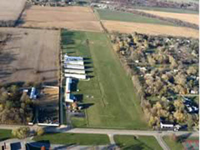
| COTTONWOOD ROCKFORD IL |
| |
| Lat: N 4217.5 Long: W 08908.2 Elev: 741 Var: -00 Longest Runway: 2540T | ||
| CTAF: 122.8 | ||
| ||||||||||||||||||||||||||||||||
| ||||||||||||||||||||||||||||||||
| Rwy | Rwy | |||||||
| 2540x260 | 2540' | 2540x260 | 2140' | |||||
| Runway ID | Single Wheel | Double Wheel | Double Tandem Wheel | Dual Double Wheel |
| 18/36 | N/A | N/A | N/A | N/A |
| These numbers are Advisory and are not limits. The Airport Manager should have more accurate Weight Limits | ||||
| FltPlan does not have IFR approach charts available for K1C8. |
| Facility Name: | COTTONWOOD |
| City Name: | ROCKFORD |
| County: | WINNEBAGO |
| State abbrev: | IL |
| State Name: | ILLINOIS |
| Ownership: | PRIVATELY OWNED |
| Use: | OPEN TO THE PUBLIC |
| Owner's Name: | COTTONWOOD CORP |
| Address: | 5105 AUBURN ST |
| ROCKFORD, IL 61101 | |
| Owner's Phone: | 779-771-1192 |
| Manager's Name: | RON VOSS |
| Address: | 6137 GARRETT LANE #4; EMAIL ADDRESS: COTTONWOODCORP@GMAIL.COM (ALL LOWER CASE) |
| ROCKFORD, IL 61107 | |
| Phone: | 779-771-1192 |
| FAA Region: | GREAT LAKES |
| FAA Field Office: | CHI |
| Date | Sunrise | Sunset |
|---|---|---|
| 06/08/26 Monday | 5:20 | 20:31 |
| 06/09/26 Tuesday | 5:20 | 20:32 |
| 06/10/26 Wednesday | 5:20 | 20:32 |
| 06/11/26 Thursday | 5:20 | 20:33 |
| 06/12/26 Friday | 5:19 | 20:33 |
| 06/13/26 Saturday | 5:19 | 20:34 |
| 06/14/26 Sunday | 5:19 | 20:34 |
| 06/15/26 Monday | 5:19 | 20:35 |
| 06/16/26 Tuesday | 5:19 | 20:35 |
| 06/17/26 Wednesday | 5:19 | 20:36 |
| 06/18/26 Thursday | 5:19 | 20:36 |
| 06/19/26 Friday | 5:20 | 20:36 |
| 06/20/26 Saturday | 5:20 | 20:36 |
| 06/21/26 Sunday | 5:20 | 20:37 |
| Airport Attendance Schedule | UNATTENDED |
| Airport Status | OPERATIONAL (This Status can change at any time - please check NOTAMS) |
| Airport Lighting Schedule | SS-SR |
| Airport Storage Available | NONE |
| Extra Services Available | NONE |
| Wind Indicator | YES - (unlit) |
| Control Tower | NO |
| CTAF Frequency | 122.800 |
| Unicom Frequency | 122.800 |
| Rotating Beacon Color | |
| Segmented Circle | YES |
| Landing Fee | NO |
| Airport Inspected | STATE - performed by STATE AERONAUTICAL PERSONNEL |
| Inspection Date | 08/29/2023 |
| Type of Fuel Available | None |
| Airframe Repair Service | MINOR REPAIRS AVBL ON REQ. |
| Power Plant Repair Service | None |
| Latitude | N4217.5 |
| Longitude | W08908.2 (ESTIMATED) |
| Arpt Elevation | 741ft (SURVEYED) |
| Magnetic Variation | 00E |
| 2 miles NW | of ROCKFORD |
| Traffic Pattern Altitude | 300; TPA: 300 FT AGL ULTRALIGHTS, 800 FT AGL SNGL ENG. |
| Sectional Chart | CHICAGO |
| Operations (Reported) | Yearly | Avg. Daily |
|---|---|---|
| General Aviation Transient | 0 | 0 |
| General Aviation Local | 0 | 0 |
| Air Taxi | 0 | 0 |
| Commerical | 0 | 0 |
| Commuter | 0 | 0 |
| Military | 0 | 0 |
| Aircraft based on Field | |
|---|---|
| General Aviation Singles | 0 |
| General Aviation Multi | 0 |
| Jet Aircraft | 0 |
| General Aviation Helicopters | 0 |
| Military Aircraft | 0 |
| Gliders | 0 |
| Ultralights | 0 |
| FSS on field | NO |
| FSS tie-in | KANKAKEE |
| FSS Phone | 1-800-WX-BRIEF |
| Who issues Notams | IKK |
| Notam D service at airport | YES |
| ARTCC Name | CHICAGO |
| Airport Certification | |
| Aircraft Rescue & Firefighting Index | None |
| Airport of Entry | No |
| Custom Landing Rights | No |
| Joint Civil/Military | No |
| Military Landing rights | No |
| RY 36: +70' LGTD STADIUM POLES L & R 1300' FM RY END. |
| SEASONAL CROPS IN RY 18 PART 77 SFC 130 FT FROM RY END. |
| FOR CD CTC CHICAGO ARTCC AT 630-906-8921. |
| RWY 18/3 6 NSTD LIRL S 2250 FT LGTD; VARIABLE INTST AND NON-FRANGIBLE MOUNTS. |
| Runway: 18 | Runway: 36 | ||
| Mag heading: | N/A | Mag heading: | N/A |
| Rwy Slope: | .00% | Rwy Slope: | .00% |
| Approach: | Approach: | ||
| Pattern: | Right Traffic | Pattern: | Left Traffic |
| Markings: | NONE | Markings: | NONE |
| Marking Condition: | Marking Condition: | ||
| Arresting Dev: | Arresting Dev: | ||
| Lat & Long: | N4217.7 W08908.2 | Lat. & Long.: | N4217.3 W08908.2 |
| Elev: | 740.0 ft. MSL | Elev: | 740.0 ft. MSL |
| TCH: | TCH: | ||
| Visual Glide Path: | Visual Glide Path: | ||
| Displaced Threshold: | No | Displaced Threshold: | 400 feet; DSPLCD THLD MARKED WITH WHITE BARRELS & LGTS. |
| Touchdown Zone: | NO | Touchdown Zone: | NO |
| Touchdown Elev.: | Touchdown Elev.: | ||
| Visual Glide Slope: | Visual Glide Slope: | ||
| RVR Equipment: | RVR Equipment: | ||
| RVV Equipment: | NO | RVV Equipment: | NO |
| Approach Lights: | Approach Lights: | ||
| REIL: | NO | REIL: | NO |
| Centerline Lights: | NO | Centerline Lights: | NO |
| Touchdown lights: | NO | Touchdown lights: | NO |
| Runway Category: | Runway with a Visual Approach | Runway Category: | Runway with a Visual Approach |
| Declared Distances: | Declared Distances: | ||
| Obstructions: | Obstructions: | ROAD | |
| Marked: | Marked: | NOT Marked/Lighted | |
| Clearance slope: | 50:1 | Clearance slope: | 2:1; RWY 36 APCH RATIO 20:1 TO DTHR. |
| Obstruction height: | Obstruction height: | 15 feet AGL | |
| Dist. from runway: | Dist. from runway: | 37 feet | |
| Centerline offset: | Centerline offset: | 130B | |
| Comments: | Comments: |
Thanks for using FltPlan.com
all rights reserved © 1999-2026 by Flight Plan LLC