| BOLINGBROOK'S CLOW INTL BOLINGBROOK IL |
| |
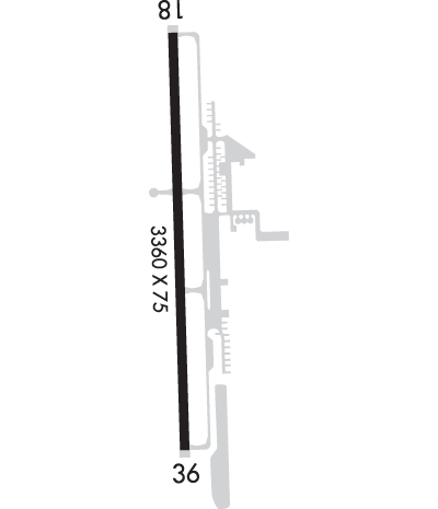
| Lat: N 4141.8 Long: W 08807.8 Elev: 675 Var: +04 Longest Runway: 3360 | ||
| CTAF: 122.9 | ||
| ||||||||||||||||||||||||||||||||||||||||||||||||||||||||||||||||||||
| ||||||||||||||||||||||||||||||||||||||||||||||||||||||||||||||||||||
| Rwy | Rwy | |||||||
| 3360x75 | 3360' | 3360x75 | 3360' | |||||
| Runway ID | Single Wheel | Double Wheel | Double Tandem Wheel | Dual Double Wheel |
| 18/36 | 12,500 | N/A | N/A | N/A |
| These numbers are Advisory and are not limits. The Airport Manager should have more accurate Weight Limits | ||||
 Airport Diagram might not be current. | |
| Facility Name: | BOLINGBROOK'S CLOW INTL |
| City Name: | BOLINGBROOK |
| County: | WILL |
| State abbrev: | IL |
| State Name: | ILLINOIS |
| Ownership: | PUBLICLY OWNED |
| Use: | OPEN TO THE PUBLIC |
| Owner's Name: | VILLAGE OF BOLINGBROOK |
| Address: | 375 W BRIARCLIFF ROAD |
| BOLINGBROOK, IL 60440 | |
| Owner's Phone: | 630-226-8400 |
| Manager's Name: | JOSEPH DE PAULO |
| Address: | 130 S CLOW INTL PARKWAY; EMAIL ADDRESS: JOEDEPAULO@GMAIL.COM |
| BOLINGBROOK, IL 60490 | |
| Phone: | 630-378-0479 |
| FAA Region: | GREAT LAKES |
| FAA Field Office: | CHI |

| Date | Sunrise | Sunset |
|---|---|---|
| 09/24/21 Friday | 6:42 | 18:47 |
| 09/25/21 Saturday | 6:43 | 18:45 |
| 09/26/21 Sunday | 6:44 | 18:43 |
| 09/27/21 Monday | 6:45 | 18:41 |
| 09/28/21 Tuesday | 6:46 | 18:40 |
| 09/29/21 Wednesday | 6:47 | 18:38 |
| 09/30/21 Thursday | 6:48 | 18:36 |
| 10/01/21 Friday | 6:49 | 18:35 |
| 10/02/21 Saturday | 6:50 | 18:33 |
| 10/03/21 Sunday | 6:51 | 18:31 |
| 10/04/21 Monday | 6:52 | 18:30 |
| 10/05/21 Tuesday | 6:53 | 18:28 |
| 10/06/21 Wednesday | 6:54 | 18:26 |
| 10/07/21 Thursday | 6:56 | 18:25 |
| Airport Attendance Schedule | 7 Days A Week 0700-1800 |
| Airport Status | OPERATIONAL (This Status can change at any time - please check NOTAMS) |
| Airport Lighting Schedule | MIRL RY 18/36 PRESET LOW INTST DUSK-DAWN TO INCR INTST - CTAF |
| Airport Storage Available | Tie Downs, Hanger |
| Extra Services Available | Charter, Flight Instruction, Aircraft Rental, Aircraft Sales |
| Wind Indicator | YES - (lighted) |
| Control Tower | NO |
| CTAF Frequency | 122.900 |
| Unicom Frequency | |
| Rotating Beacon Color | CLEAR-GREEN (Light Land Airport) |
| Segmented Circle | NO |
| Landing Fee | NO |
| Airport Inspected | STATE - performed by STATE AERONAUTICAL PERSONNEL |
| Inspection Date | 08/05/2020 |
| Type of Fuel Available | Grade 100LL, JET A (freeze point -40C) |
| Airframe Repair Service | MAJOR |
| Power Plant Repair Service | MAJOR |
| Latitude | N4141.8 |
| Longitude | W08807.8 (ESTIMATED) |
| Arpt Elevation | 674ft (ESTIMATED) |
| Magnetic Variation | 04W |
| 0 miles NW | of BOLINGBROOK |
| Traffic Pattern Altitude | 830 |
| Sectional Chart | CHICAGO |
| Operations (Reported) | Yearly | Avg. Daily |
|---|---|---|
| General Aviation Transient | 22000 | 60 |
| General Aviation Local | 26000 | 71 |
| Air Taxi | 2000 | 5 |
| Commerical | 0 | 0 |
| Commuter | 0 | 0 |
| Military | 0 | 0 |
| Aircraft based on Field | |
|---|---|
| General Aviation Singles | 55 |
| General Aviation Multi | 7 |
| Jet Aircraft | 0 |
| General Aviation Helicopters | 1 |
| Military Aircraft | 0 |
| Gliders | 0 |
| Ultralights | 0 |
| FSS on field | NO |
| FSS tie-in | KANKAKEE |
| FSS Phone | 1-800-WX-BRIEF |
| Who issues Notams | IKK |
| Notam D service at airport | YES |
| ARTCC Name | CHICAGO |
| Airport Certification | |
| Aircraft Rescue & Firefighting Index | None |
| Airport of Entry | No |
| Custom Landing Rights | No |
| Joint Civil/Military | No |
| Military Landing rights | No |
| NATIONAL PLAN OF INTEGRATED AIRPORT SYSTEMS (NPIAS) |
| TWY 20 FT WIDE; LARGE ACFT CONSIDER BACK-TAXI. |
| NO TGL; FULL STOP LDG ONLY. |
| FOR CD CTC CHICAGO APCH AT 847-289-0926. |
| FLT SCHOOL OPS ONLY - 123.50. |
| WILDLIFE ON AND INVOF ARPT. |
| RESTAURANT ON ARPT. |
| RWY 18 USE RWY 18 IN CALM WND OR DRCT CROSSWINDS. |
Airport Communications & Frequencies:
| ||||||||||||
| Runway: 18 | Runway: 36 | ||
| Mag heading: | 182° | Mag heading: | 2° |
| Rwy Slope: | -.53% Down | Rwy Slope: | .53% Up |
| Approach: | Approach: | ||
| Pattern: | Left Traffic | Pattern: | Left Traffic |
| Markings: | NONPRECISION INSTRUMENT | Markings: | NONPRECISION INSTRUMENT |
| Marking Condition: | GOOD | Marking Condition: | GOOD |
| Arresting Dev: | Arresting Dev: | ||
| Lat & Long: | N4142.0 W08807.8 | Lat. & Long.: | N4141.5 W08807.8 |
| Elev: | 674.9 ft. MSL | Elev: | 657.0 ft. MSL |
| TCH: | TCH: | ||
| Visual Glide Path: | Visual Glide Path: | ||
| Displaced Threshold: | No | Displaced Threshold: | No |
| Touchdown Zone: | YES | Touchdown Zone: | YES |
| Touchdown Elev.: | 674.9 feet | Touchdown Elev.: | 672.0 feet |
| Visual Glide Slope: | Visual Glide Slope: | ||
| RVR Equipment: | RVR Equipment: | ||
| RVV Equipment: | NO | RVV Equipment: | NO |
| Approach Lights: | Approach Lights: | ||
| REIL: | NO | REIL: | NO |
| Centerline Lights: | NO | Centerline Lights: | NO |
| Touchdown lights: | NO | Touchdown lights: | NO |
| Runway Category: | Runway with a Visual Approach | Runway Category: | Runway with a Visual Approach |
| Declared Distances: | Declared Distances: |
Thanks for using FltPlan.com
all rights reserved © 1999-2021 by Flight Plan LLC