
| DEXTER RGNL DEXTER ME |
| |
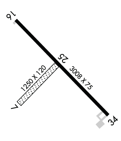
| Lat: N 4500.3 Long: W 06914.2 Elev: 533 Var: +18 Longest Runway: 3008 | ||
| CTAF: 122.8 | ||
| ||||||
|
| Rwy | Rwy | |||||||
| 1249x120 | 1249' | 1249x120 | 1249' | |||||
| 3008x75 | 3008' | 3008x75 | 3008' | |||||
| Runway ID | Single Wheel | Double Wheel | Double Tandem Wheel | Dual Double Wheel |
| 07/25 | N/A | N/A | N/A | N/A |
| 16/34 | 30,000 | N/A | N/A | N/A |
| These numbers are Advisory and are not limits. The Airport Manager should have more accurate Weight Limits | ||||
 Airport Diagram might not be current. | |
| Facility Name: | DEXTER RGNL |
| City Name: | DEXTER |
| County: | PENOBSCOT |
| State abbrev: | ME |
| State Name: | MAINE |
| Ownership: | PUBLICLY OWNED |
| Use: | OPEN TO THE PUBLIC |
| Owner's Name: | TOWN OF DEXTER |
| Address: | TOWN OFFICE BLDG, 23 MAIN |
| DEXTER, ME 04930 | |
| Owner's Phone: | 207-924-7351 |
| Manager's Name: | ROGER NELSON |
| Address: | 129 OLD BANGOR RD |
| NEWPORT, ME 04953 | |
| Phone: | 207-270-0239 |
| FAA Region: | NEW ENGLAND |
| FAA Field Office: | NONE |
| Date | Sunrise | Sunset |
|---|---|---|
| 06/08/26 Monday | 4:51 | 20:22 |
| 06/09/26 Tuesday | 4:50 | 20:22 |
| 06/10/26 Wednesday | 4:50 | 20:23 |
| 06/11/26 Thursday | 4:50 | 20:23 |
| 06/12/26 Friday | 4:50 | 20:24 |
| 06/13/26 Saturday | 4:50 | 20:24 |
| 06/14/26 Sunday | 4:50 | 20:25 |
| 06/15/26 Monday | 4:50 | 20:25 |
| 06/16/26 Tuesday | 4:50 | 20:26 |
| 06/17/26 Wednesday | 4:50 | 20:26 |
| 06/18/26 Thursday | 4:50 | 20:26 |
| 06/19/26 Friday | 4:50 | 20:27 |
| 06/20/26 Saturday | 4:50 | 20:27 |
| 06/21/26 Sunday | 4:50 | 20:27 |
| Airport Attendance Schedule | UNATTENDED |
| Airport Status | OPERATIONAL (This Status can change at any time - please check NOTAMS) |
| Airport Lighting Schedule | ACTVT MIRL RWY 16/34 - CTAF. |
| Airport Storage Available | Tie Downs |
| Extra Services Available | NONE |
| Wind Indicator | YES - (lighted) |
| Control Tower | NO |
| CTAF Frequency | 122.800 |
| Unicom Frequency | 122.800 |
| Rotating Beacon Color | WG |
| Segmented Circle | YES |
| Landing Fee | NO |
| Airport Inspected | STATE - performed by PRIVATE CONTRACT PERSONNEL |
| Inspection Date | 08/15/2024 |
| Type of Fuel Available | Grade 100LLMOGAS; -1024 HR FUEL WITH MAJOR CREDIT CARD, NO ETHANOL IN MOGAS. |
| Airframe Repair Service | NONE |
| Power Plant Repair Service | NONE |
| Latitude | N4500.3 |
| Longitude | W06914.2 (ESTIMATED) |
| Arpt Elevation | 533ft (SURVEYED) |
| Magnetic Variation | 18W |
| 3 miles E | of DEXTER |
| Traffic Pattern Altitude | |
| Sectional Chart | MONTREAL |
| Operations (Reported) | Yearly | Avg. Daily |
|---|---|---|
| General Aviation Transient | 0 | 0 |
| General Aviation Local | 0 | 0 |
| Air Taxi | 0 | 0 |
| Commerical | 0 | 0 |
| Commuter | 0 | 0 |
| Military | 0 | 0 |
| Aircraft based on Field | |
|---|---|
| General Aviation Singles | 0 |
| General Aviation Multi | 0 |
| Jet Aircraft | 0 |
| General Aviation Helicopters | 0 |
| Military Aircraft | 0 |
| Gliders | 0 |
| Ultralights | 0 |
| FSS on field | NO |
| FSS tie-in | BANGOR |
| FSS Phone | 1-800-WX-BRIEF |
| Who issues Notams | BGR |
| Notam D service at airport | YES |
| ARTCC Name | BOSTON |
| Airport Certification | |
| Aircraft Rescue & Firefighting Index | None |
| Airport of Entry | No |
| Custom Landing Rights | No |
| Joint Civil/Military | No |
| Military Landing rights | YES |
| NATIONAL PLAN OF INTEGRATED AIRPORT SYSTEMS (NPIAS) |
| GRANT AGREEMENTS UNDER FAAP/ADAP/AIP |
| ASSURANCES PURSUANT TO TITLE VI, CIVIL RIGHTS ACT OF 1964 |
| AGREEMENT UNDER DLAND OR DCLA HAS EXPIRED. |
| WILDLIFE ON OR INVOF ARPT. |
| FOR CD CTC BANGOR APCH AT 207-561-2500 EXTN 1. |
| TXL A CLSD TO ACFT WITH WINGSPAN GTR THAN 36 FT. |
| TXL A RSTRD TO BASED ACFT ONLY. |
Airport Communications & Frequencies:
| ||||||||||||||
| Runway: 07 | Runway: 25 | ||
| Mag heading: | 67° | Mag heading: | 247° |
| Rwy Slope: | -.55% Down | Rwy Slope: | .55% Up |
| Approach: | Approach: | ||
| Pattern: | Left Traffic | Pattern: | Left Traffic |
| Markings: | Markings: | ||
| Marking Condition: | FAIR | Marking Condition: | FAIR |
| Arresting Dev: | Arresting Dev: | ||
| Lat & Long: | N4500.1 W06914.4 | Lat. & Long.: | N4500.3 W06914.2 |
| Elev: | 533.3 ft. MSL | Elev: | 526.4 ft. MSL |
| TCH: | TCH: | ||
| Visual Glide Path: | Visual Glide Path: | ||
| Displaced Threshold: | No | Displaced Threshold: | No |
| Touchdown Zone: | YES | Touchdown Zone: | YES |
| Touchdown Elev.: | 533.3 feet | Touchdown Elev.: | 533.3 feet |
| Visual Glide Slope: | Visual Glide Slope: | ||
| RVR Equipment: | RVR Equipment: | ||
| RVV Equipment: | NO | RVV Equipment: | NO |
| Approach Lights: | Approach Lights: | ||
| REIL: | NO | REIL: | NO |
| Centerline Lights: | NO | Centerline Lights: | NO |
| Touchdown lights: | NO | Touchdown lights: | NO |
| Runway Category: | Runway with a Visual Approach | Runway Category: | Runway with a Visual Approach |
| Declared Distances: | Declared Distances: |
| Runway: 16 | Runway: 34 | ||
| Mag heading: | 157° | Mag heading: | 337° |
| Rwy Slope: | .10% Up | Rwy Slope: | -.10% Down |
| Approach: | Approach: | ||
| Pattern: | Left Traffic | Pattern: | Left Traffic |
| Markings: | NONPRECISION INSTRUMENT | Markings: | NONPRECISION INSTRUMENT |
| Marking Condition: | GOOD | Marking Condition: | GOOD |
| Arresting Dev: | Arresting Dev: | ||
| Lat & Long: | N4500.5 W06914.5 | Lat. & Long.: | N4500.1 W06914.0 |
| Elev: | 520.8 ft. MSL | Elev: | 523.7 ft. MSL |
| TCH: | TCH: | ||
| Visual Glide Path: | Visual Glide Path: | ||
| Displaced Threshold: | No | Displaced Threshold: | No |
| Touchdown Zone: | YES | Touchdown Zone: | YES |
| Touchdown Elev.: | 526.5 feet | Touchdown Elev.: | 526.5 feet |
| Visual Glide Slope: | Visual Glide Slope: | ||
| RVR Equipment: | RVR Equipment: | ||
| RVV Equipment: | NO | RVV Equipment: | NO |
| Approach Lights: | Approach Lights: | ||
| REIL: | NO | REIL: | NO |
| Centerline Lights: | NO | Centerline Lights: | NO |
| Touchdown lights: | NO | Touchdown lights: | NO |
| Runway Category: | Runway with a Non-precision Approach | Runway Category: | Runway with a Non-precision Approach |
| Declared Distances: | Declared Distances: |
Thanks for using FltPlan.com
all rights reserved © 1999-2026 by Flight Plan LLC
