
| MIDDLESBORO-BELL COUNTY MIDDLESBORO KY |
| |
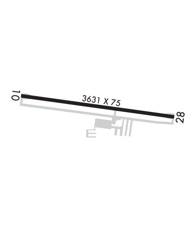
| Lat: N 3636.6 Long: W 08344.2 Elev: 1154 Var: +05 Longest Runway: 3631 | ||
| AWOS: 119.42 CTAF: 122.8 | ||
| ||||||||||||||||||||||||||||||||
| ||||||||||||||||||||||||||||||||
| ||||||||||||||||||||||||||||||||
| Rwy | Rwy | |||||||
| 3631x75 | 3402' | 3631x75 | 3552' | |||||
| Runway ID | Single Wheel | Double Wheel | Double Tandem Wheel | Dual Double Wheel |
| 10/28 | 19,000 | N/A | N/A | N/A |
| These numbers are Advisory and are not limits. The Airport Manager should have more accurate Weight Limits | ||||
 Airport Diagram might not be current. | |
| Facility Name: | MIDDLESBORO-BELL COUNTY |
| City Name: | MIDDLESBORO |
| County: | BELL |
| State abbrev: | KY |
| State Name: | KENTUCKY |
| Ownership: | PUBLICLY OWNED |
| Use: | OPEN TO THE PUBLIC |
| Owner's Name: | CITY OF MIDDLESBORO & BELL COUNTY |
| Address: | 2116 CUMBERLAND AVE |
| MIDDLESBORO, KY 40965 | |
| Owner's Phone: | 606-248-2551; (606) 269-6910 |
| Manager's Name: | GLYNNA BROWN |
| Address: | 2116 CUMBERLAND AVE |
| MIDDLESBORO, KY 40965 | |
| Phone: | 606-242-3134 |
| FAA Region: | SOUTHERN |
| FAA Field Office: | MEM |

| Date | Sunrise | Sunset |
|---|---|---|
| 09/24/21 Friday | 7:24 | 19:29 |
| 09/25/21 Saturday | 7:25 | 19:28 |
| 09/26/21 Sunday | 7:26 | 19:26 |
| 09/27/21 Monday | 7:27 | 19:25 |
| 09/28/21 Tuesday | 7:27 | 19:23 |
| 09/29/21 Wednesday | 7:28 | 19:22 |
| 09/30/21 Thursday | 7:29 | 19:20 |
| 10/01/21 Friday | 7:30 | 19:19 |
| 10/02/21 Saturday | 7:31 | 19:17 |
| 10/03/21 Sunday | 7:32 | 19:16 |
| 10/04/21 Monday | 7:32 | 19:14 |
| 10/05/21 Tuesday | 7:33 | 19:13 |
| 10/06/21 Wednesday | 7:34 | 19:11 |
| 10/07/21 Thursday | 7:35 | 19:10 |
| Airport Attendance Schedule | 7 Days A Week 0800-1700; FOR SVCS CALL 606-242-3134 OR 606-248-3563. |
| Airport Status | OPERATIONAL (This Status can change at any time - please check NOTAMS) |
| Airport Lighting Schedule | REIL RWY 10 AND 28 OPR CONS DAY ONLY. |
| Airport Storage Available | Tie Downs, Hanger |
| Extra Services Available | NONE |
| Wind Indicator | YES - (unlit) |
| Control Tower | NO |
| CTAF Frequency | 122.800 |
| Unicom Frequency | 122.800 |
| Rotating Beacon Color | |
| Segmented Circle | YES |
| Landing Fee | NO |
| Airport Inspected | STATE - performed by STATE AERONAUTICAL PERSONNEL |
| Inspection Date | 07/25/2019 |
| Type of Fuel Available | Grade 100LL, JET A |
| Airframe Repair Service | MAJOR |
| Power Plant Repair Service | MAJOR |
| Latitude | N3636.6 |
| Longitude | W08344.2 (ESTIMATED) |
| Arpt Elevation | 1154ft (SURVEYED) |
| Magnetic Variation | 05W |
| 1 miles W | of MIDDLESBORO |
| Traffic Pattern Altitude | |
| Sectional Chart | CINCINNATI |
| Operations (Reported) | Yearly | Avg. Daily |
|---|---|---|
| General Aviation Transient | 7500 | 21 |
| General Aviation Local | 9350 | 26 |
| Air Taxi | 500 | 1 |
| Commerical | 0 | 0 |
| Commuter | 0 | 0 |
| Military | 200 | 1 |
| Aircraft based on Field | |
|---|---|
| General Aviation Singles | 10 |
| General Aviation Multi | 2 |
| Jet Aircraft | 0 |
| General Aviation Helicopters | 0 |
| Military Aircraft | 0 |
| Gliders | 0 |
| Ultralights | 0 |
| FSS on field | NO |
| FSS tie-in | LOUISVILLE |
| FSS Phone | 1-800-WX-BRIEF |
| Who issues Notams | LOU |
| Notam D service at airport | YES |
| ARTCC Name | INDIANAPOLIS |
| Airport Certification | |
| Aircraft Rescue & Firefighting Index | None |
| Airport of Entry | No |
| Custom Landing Rights | No |
| Joint Civil/Military | No |
| Military Landing rights | YES |
| NATIONAL PLAN OF INTEGRATED AIRPORT SYSTEMS (NPIAS) |
| GRANT AGREEMENTS UNDER FAAP/ADAP/AIP |
| ASSURANCES PURSUANT TO TITLE VI, CIVIL RIGHTS ACT OF 1964 |
| ULTRALIGHT ACT ON & INVOF ARPT. |
| TREES BOTH SIDES OF RWY VIOLATE 7:1 TRANSITIONAL SFCS. |
| NARROW TWYS MAY REQUIRE LG ACFT TO BACK TAXI TO/FR APRON. |
| FOR CD CTC INDIANAPOLIS ARTCC AT 317-247-2411. |
| COLD TEMPERATURE AIRPORT. ALTITUDE CORRECTION REQUIRED AT OR BELOW -14C. |
| RWY 10/2 8 DALGT OPS ONLY. |
Airport Communications & Frequencies:
| |||||||||
| Runway: 10 | Runway: 28 | ||
| Mag heading: | 103° | Mag heading: | 283° |
| Rwy Slope: | -.40% Down | Rwy Slope: | .40% Up |
| Approach: | Approach: | ||
| Pattern: | Left Traffic | Pattern: | Left Traffic |
| Markings: | BASIC | Markings: | BASIC |
| Marking Condition: | POOR; MARKINGS FADED AND ALGAE COVERED | Marking Condition: | POOR; MARKINGS FADED AND ALGAE COVERED |
| Arresting Dev: | Arresting Dev: | ||
| Lat & Long: | N3636.7 W08344.6 | Lat. & Long.: | N3636.6 W08343.9 |
| Elev: | 1154.1 ft. MSL | Elev: | 1139.6 ft. MSL |
| TCH: | TCH: | ||
| Visual Glide Path: | Visual Glide Path: | ||
| Displaced Threshold: | 229 feet | Displaced Threshold: | 79 feet |
| Touchdown Zone: | YES | Touchdown Zone: | YES |
| Touchdown Elev.: | 1152.4 feet | Touchdown Elev.: | 1150.1 feet |
| Visual Glide Slope: | Visual Glide Slope: | NONSTANDARD VASI SYSTEM; TWO BOX LEFT AND RIGHT OF RWY ON DALGT ONLY. | |
| RVR Equipment: | RVR Equipment: | ||
| RVV Equipment: | NO | RVV Equipment: | NO |
| Approach Lights: | Approach Lights: | ||
| REIL: | YES | REIL: | YES |
| Centerline Lights: | NO | Centerline Lights: | NO |
| Touchdown lights: | NO | Touchdown lights: | NO |
| Runway Category: | Runway with a Visual Approach | Runway Category: | Runway with a Visual Approach |
| Declared Distances: | Declared Distances: | ||
| Obstructions: | TREES; 4 FT FENCE 220 FT FM RWY END; 200 FT LEFT AND RIGHT. | Obstructions: | ROAD |
| Marked: | NOT Marked/Lighted | Marked: | NOT Marked/Lighted |
| Clearance slope: | 3:1; APCH RATIO 8:1 TO DSPLCD THR. | Clearance slope: | 1:1; APCH RATIO 25:1 TO DSPLCD THR. |
| Obstruction height: | 90 feet AGL | Obstruction height: | 12 feet AGL |
| Dist. from runway: | 535 feet | Dist. from runway: | 223 feet |
| Centerline offset: | 288 right of centerline | Centerline offset: | |
| Comments: | 10 FT BERM 230 FT FM RWY END 110 FT R; +4 FT FENCE 157 FT FM RWY END; +17 FT ROAD 183 FT FM RWY END. | Comments: |
Thanks for using FltPlan.com
all rights reserved © 1999-2021 by Flight Plan LLC