
| MACON COUNTY FRANKLIN NC |
| |
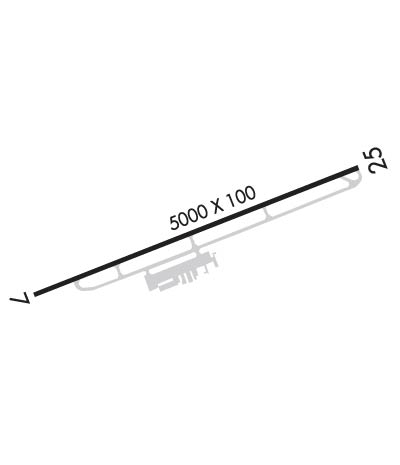
| Lat: N 3513.3 Long: W 08325.2 Elev: 2034 Var: +05 Longest Runway: 5002 | ||
| AWOS: 118.22 CTAF: 123.05 | ||
| ||||||||||||||||||||||||||||||||||||||||||||
| ||||||||||||||||||||||||||||||||||||||||||||
| ||||||||||||||||||||||||||||||||||||||||||||
| Rwy | Rwy | |||||||
| 5002x100 | 5002' | 5002x100 | 5002' | |||||
| Runway ID | Single Wheel | Double Wheel | Double Tandem Wheel | Dual Double Wheel |
| 07/25 | 30,000 | 60,000 | N/A | N/A |
| These numbers are Advisory and are not limits. The Airport Manager should have more accurate Weight Limits | ||||
 Airport Diagram might not be current. | |
| Facility Name: | MACON COUNTY |
| City Name: | FRANKLIN |
| County: | MACON |
| State abbrev: | NC |
| State Name: | NORTH CAROLINA |
| Ownership: | PUBLICLY OWNED |
| Use: | OPEN TO THE PUBLIC |
| Owner's Name: | MACON COUNTY AIRPORT AUTHORITY |
| Address: | 1241 AIRPORT ROAD |
| FRANKLIN, NC 28734 | |
| Owner's Phone: | 828-524-7121 |
| Manager's Name: | SABRINA CRONE |
| Address: | 1241 AIRPORT ROAD |
| FRANKLIN, NC 28734-1513 | |
| Phone: | 828-524-5529 |
| FAA Region: | SOUTHERN |
| FAA Field Office: | MEM |
| Date | Sunrise | Sunset |
|---|---|---|
| 06/08/26 Monday | 6:19 | 20:47 |
| 06/09/26 Tuesday | 6:19 | 20:47 |
| 06/10/26 Wednesday | 6:19 | 20:48 |
| 06/11/26 Thursday | 6:19 | 20:48 |
| 06/12/26 Friday | 6:18 | 20:49 |
| 06/13/26 Saturday | 6:18 | 20:49 |
| 06/14/26 Sunday | 6:19 | 20:49 |
| 06/15/26 Monday | 6:19 | 20:50 |
| 06/16/26 Tuesday | 6:19 | 20:50 |
| 06/17/26 Wednesday | 6:19 | 20:50 |
| 06/18/26 Thursday | 6:19 | 20:51 |
| 06/19/26 Friday | 6:19 | 20:51 |
| 06/20/26 Saturday | 6:19 | 20:51 |
| 06/21/26 Sunday | 6:19 | 20:51 |
| Airport Attendance Schedule | 7 Days A Week 0800-1830; AFLD SVC AVBL 0800-1830 EXCLD HOL. |
| Airport Status | OPERATIONAL (This Status can change at any time - please check NOTAMS) |
| Airport Lighting Schedule | PAPI RWY 07 & 25; MIRL RWY 07/25 ON DUSK - DAWN. TO INCR INTST - CTAF. |
| Airport Storage Available | Tie Downs, Hanger |
| Extra Services Available | Flight Instruction, Aircraft Rental |
| Wind Indicator | YES - (lighted) |
| Control Tower | NO |
| CTAF Frequency | 123.050 |
| Unicom Frequency | 123.050 |
| Rotating Beacon Color | WG; ARPT BCN LCTD 3/4 MILE SE OF ARPT. |
| Segmented Circle | YES |
| Landing Fee | NO |
| Airport Inspected | STATE - performed by STATE AERONAUTICAL PERSONNEL |
| Inspection Date | 07/27/2023 |
| Type of Fuel Available | Grade 100LL, JET A-1 (icing inhibitor, freeze point -50C); -10100LL AND JET A 24 HR SELF-SERVICE WITH CREDIT CARD. |
| Airframe Repair Service | MAJOR |
| Power Plant Repair Service | MAJOR |
| Latitude | N3513.3 |
| Longitude | W08325.2 (ESTIMATED) |
| Arpt Elevation | 2033ft (SURVEYED) |
| Magnetic Variation | 05W |
| 3 miles NW | of FRANKLIN |
| Traffic Pattern Altitude | 780 |
| Sectional Chart | ATLANTA |
| Operations (Reported) | Yearly | Avg. Daily |
|---|---|---|
| General Aviation Transient | 0 | 0 |
| General Aviation Local | 0 | 0 |
| Air Taxi | 0 | 0 |
| Commerical | 0 | 0 |
| Commuter | 0 | 0 |
| Military | 0 | 0 |
| Aircraft based on Field | |
|---|---|
| General Aviation Singles | 0 |
| General Aviation Multi | 0 |
| Jet Aircraft | 0 |
| General Aviation Helicopters | 0 |
| Military Aircraft | 0 |
| Gliders | 0 |
| Ultralights | 0 |
| FSS on field | NO |
| FSS tie-in | RALEIGH |
| FSS Phone | 1-800-WX-BRIEF |
| Who issues Notams | RDU |
| Notam D service at airport | YES |
| ARTCC Name | ATLANTA |
| Airport Certification | |
| Aircraft Rescue & Firefighting Index | None |
| Airport of Entry | No |
| Custom Landing Rights | No |
| Joint Civil/Military | No |
| Military Landing rights | YES |
| NATIONAL PLAN OF INTEGRATED AIRPORT SYSTEMS (NPIAS) |
| GRANT AGREEMENTS UNDER FAAP/ADAP/AIP |
| ASSURANCES PURSUANT TO TITLE VI, CIVIL RIGHTS ACT OF 1964 |
| FOR CD CTC ATLANTA ARTCC AT 770-210-7692. |
| COLD TEMPERATURE AIRPORT. ALTITUDE CORRECTION REQUIRED AT OR BELOW -11C. |
| RPDLY RSG TRRN ALL QUADS. |
| RWY 25 HAS A 15 FT DROP-OFF 350 FT FM THR L & R. |
Airport Communications & Frequencies:
| |||||||||
| Runway: 07 | Runway: 25 | ||
| Mag heading: | 74° | Mag heading: | 254° |
| Rwy Slope: | -.48% Down | Rwy Slope: | .48% Up |
| Approach: | Approach: | ||
| Pattern: | Left Traffic | Pattern: | Right Traffic |
| Markings: | NONPRECISION INSTRUMENT | Markings: | NONPRECISION INSTRUMENT |
| Marking Condition: | GOOD | Marking Condition: | GOOD |
| Arresting Dev: | Arresting Dev: | ||
| Lat & Long: | N3513.2 W08325.7 | Lat. & Long.: | N3513.5 W08324.7 |
| Elev: | 2033.9 ft. MSL | Elev: | 2009.7 ft. MSL |
| TCH: | 43 ft. AGL | TCH: | 40 ft. AGL |
| Visual Glide Path: | 3.00 degrees | Visual Glide Path: | 3.00 degrees |
| Displaced Threshold: | No | Displaced Threshold: | No |
| Touchdown Zone: | YES | Touchdown Zone: | YES |
| Touchdown Elev.: | 2033.9 feet | Touchdown Elev.: | 2019.6 feet |
| Visual Glide Slope: | 2-Light PAPI on LEFT side of Runway; PAPI RWY 7 OTS INDEFLY. | Visual Glide Slope: | 2-Light PAPI on LEFT side of Runway; PAPI RWY 25 OTS INDEFLY. |
| RVR Equipment: | RVR Equipment: | ||
| RVV Equipment: | NO | RVV Equipment: | NO |
| Approach Lights: | Approach Lights: | ||
| REIL: | NO | REIL: | NO |
| Centerline Lights: | NO | Centerline Lights: | NO |
| Touchdown lights: | NO | Touchdown lights: | NO |
| Runway Category: | Runway with a Visual Approach | Runway Category: | Runway with a Visual Approach |
| Declared Distances: | Declared Distances: | ||
| Obstructions: | TREES | Obstructions: | TREES |
| Marked: | NOT Marked/Lighted | Marked: | NOT Marked/Lighted |
| Clearance slope: | 24:1 | Clearance slope: | 1:1 |
| Obstruction height: | 89 feet AGL | Obstruction height: | 12 feet AGL |
| Dist. from runway: | 2398 feet | Dist. from runway: | 215 feet |
| Centerline offset: | 33 left of centerline | Centerline offset: | 46 feet left of centerline |
| Comments: | 6 FT HILL 0-200 FT FM END OF THLD OFFSET 100 FT LEFT OF CNTRLN AND 29 FT TREES 56 FT FM END OF THLD OFFSET 227 FT LEFT. | Comments: | RWY 25 8 FT FENCE 159 FT FM END OF THR OFFSET 134 FT RIGHT OF CNTRLN AND 10 FT BRUSH 0 TO 200 FT FM THR OFFSET 168 FT LEFT OF CNTRLN. |
Thanks for using FltPlan.com
all rights reserved © 1999-2026 by Flight Plan LLC
