| CROSS KEYS CROSS KEYS NJ |
| |
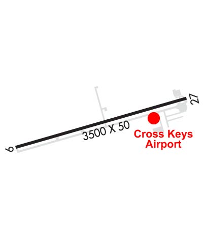
| Lat: N 3942.3 Long: W 07502.0 Elev: 162 Var: +10 Longest Runway: 3500 | ||
| CTAF: 122.8 | ||
| |||||||||||||||||||||||||||||||||||||||||||||||||||||||||||||
| |||||||||||||||||||||||||||||||||||||||||||||||||||||||||||||
| Rwy | Rwy | |||||||
| 3500x50 | 3500' | 3500x50 | 3300' | |||||
| Runway ID | Single Wheel | Double Wheel | Double Tandem Wheel | Dual Double Wheel |
| 09/27 | 13,000 | N/A | N/A | N/A |
| These numbers are Advisory and are not limits. The Airport Manager should have more accurate Weight Limits | ||||
 Airport Diagram might not be current. | |
| Facility Name: | CROSS KEYS |
| City Name: | CROSS KEYS |
| County: | GLOUCESTER |
| State abbrev: | NJ |
| State Name: | NEW JERSEY |
| Ownership: | PRIVATELY OWNED |
| Use: | OPEN TO THE PUBLIC |
| Owner's Name: | CROSS KEYS AIRPORT LLC |
| Address: | 1531 N. TUCKAHOE ROAD |
| WILLIAMSTOWN, NJ 08094 | |
| Owner's Phone: | 856-629-3033 |
| Manager's Name: | HARRY STRAHLENDORF |
| Address: | 1531 N. TUCKAHOE ROAD |
| WILLIAMSTOWN, NJ 08094 | |
| Phone: | 856-629-3033 |
| FAA Region: | EASTERN |
| FAA Field Office: | HAR |
| Date | Sunrise | Sunset |
|---|---|---|
| 06/08/26 Monday | 5:32 | 20:26 |
| 06/09/26 Tuesday | 5:32 | 20:27 |
| 06/10/26 Wednesday | 5:32 | 20:27 |
| 06/11/26 Thursday | 5:32 | 20:28 |
| 06/12/26 Friday | 5:32 | 20:28 |
| 06/13/26 Saturday | 5:32 | 20:29 |
| 06/14/26 Sunday | 5:32 | 20:29 |
| 06/15/26 Monday | 5:32 | 20:30 |
| 06/16/26 Tuesday | 5:32 | 20:30 |
| 06/17/26 Wednesday | 5:32 | 20:30 |
| 06/18/26 Thursday | 5:32 | 20:31 |
| 06/19/26 Friday | 5:32 | 20:31 |
| 06/20/26 Saturday | 5:32 | 20:31 |
| 06/21/26 Sunday | 5:32 | 20:31 |
| Airport Attendance Schedule | 7 Days A Week 0800-1700 |
| Airport Status | OPERATIONAL (This Status can change at any time - please check NOTAMS) |
| Airport Lighting Schedule | SS-SR |
| Airport Storage Available | Tie Downs |
| Extra Services Available | Flight Instruction, Parachute Jumping, Aircraft Rental |
| Wind Indicator | YES - (lighted) |
| Control Tower | NO |
| CTAF Frequency | 122.800 |
| Unicom Frequency | 122.800 |
| Rotating Beacon Color | WG |
| Segmented Circle | NO |
| Landing Fee | NO |
| Airport Inspected | STATE - performed by STATE AERONAUTICAL PERSONNEL |
| Inspection Date | 06/19/2025 |
| Type of Fuel Available | Grade 100LL, JET A (freeze point -40C) |
| Airframe Repair Service | MINOR |
| Power Plant Repair Service | MINOR |
| Latitude | N3942.3 |
| Longitude | W07502.0 (ESTIMATED) |
| Arpt Elevation | 162ft (ESTIMATED) |
| Magnetic Variation | 10W |
| 1 miles S | of CROSS KEYS |
| Traffic Pattern Altitude | 838 |
| Sectional Chart | WASHINGTON |
| Operations (Reported) | Yearly | Avg. Daily |
|---|---|---|
| General Aviation Transient | 0 | 0 |
| General Aviation Local | 0 | 0 |
| Air Taxi | 0 | 0 |
| Commerical | 0 | 0 |
| Commuter | 0 | 0 |
| Military | 0 | 0 |
| Aircraft based on Field | |
|---|---|
| General Aviation Singles | 0 |
| General Aviation Multi | 0 |
| Jet Aircraft | 0 |
| General Aviation Helicopters | 0 |
| Military Aircraft | 0 |
| Gliders | 0 |
| Ultralights | 0 |
| FSS on field | NO |
| FSS tie-in | MILLVILLE |
| FSS Phone | 1-800-WX-BRIEF |
| Who issues Notams | MIV |
| Notam D service at airport | YES |
| ARTCC Name | WASHINGTON |
| Airport Certification | |
| Aircraft Rescue & Firefighting Index | None |
| Airport of Entry | No |
| Custom Landing Rights | No |
| Joint Civil/Military | No |
| Military Landing rights | No |
| THIS AIRPORT HAS BEEN SURVEYED BY THE NATIONAL GEODETIC SURVEY. |
| DUE TO PARACHUTE DROP ZONE ON N SIDE OF ARPT, ALL TFC TO REMAIN S OF RWY 09/27. |
| DEER & BIRDS ON & INVOF ARPT. |
| ARPT UNATTND THANKSGIVING, CHRISTMAS, NEW YEAR'S DAY AND EASTER. |
| FOR CD CTC PHILADELPHIA APCH AT 800-354-9884. |
| RWY 09/2 7 LIRL LGT SPACING NSTD. |
Airport Communications & Frequencies:
| ||||||||||||||||||
| Runway: 09 | Runway: 27 | ||
| Mag heading: | 84° | Mag heading: | 264° |
| Rwy Slope: | .69% Up | Rwy Slope: | -.69% Down |
| Approach: | Approach: | ||
| Pattern: | Right Traffic | Pattern: | Left Traffic |
| Markings: | NONPRECISION INSTRUMENT | Markings: | BASIC |
| Marking Condition: | FAIR | Marking Condition: | FAIR |
| Arresting Dev: | Arresting Dev: | ||
| Lat & Long: | N3942.2 W07502.3 | Lat. & Long.: | N3942.4 W07501.6 |
| Elev: | 137.0 ft. MSL | Elev: | 161.0 ft. MSL |
| TCH: | TCH: | ||
| Visual Glide Path: | Visual Glide Path: | ||
| Displaced Threshold: | No | Displaced Threshold: | 200 feet; DSPLCD THLD MARKED WITH LGTS. |
| Touchdown Zone: | YES | Touchdown Zone: | YES |
| Touchdown Elev.: | 162.0 feet | Touchdown Elev.: | 162.0 feet |
| Visual Glide Slope: | Visual Glide Slope: | ||
| RVR Equipment: | RVR Equipment: | ||
| RVV Equipment: | NO | RVV Equipment: | NO |
| Approach Lights: | Approach Lights: | ||
| REIL: | NO | REIL: | NO |
| Centerline Lights: | NO | Centerline Lights: | NO |
| Touchdown lights: | NO | Touchdown lights: | NO |
| Runway Category: | Runway with a Non-precision Approach | Runway Category: | Runway with a Visual Approach |
| Declared Distances: | Declared Distances: | ||
| Obstructions: | TREES | Obstructions: | TREE; ROAD, FENCE, BLDGS, & TREES NEAR APCH END. |
| Marked: | NOT Marked/Lighted | Marked: | NOT Marked/Lighted |
| Clearance slope: | 7:1 | Clearance slope: | 5:1 |
| Obstruction height: | 90 feet AGL | Obstruction height: | 73 feet AGL |
| Dist. from runway: | 900 feet | Dist. from runway: | 570 feet |
| Centerline offset: | 250 left of centerline; TREES ARE 125' R & L OF CNTRL EXTNDD. | Centerline offset: | 135 feet right of centerline |
| Comments: | +20 FT TREES 50 FT RT & LFT OF EXTD CTLN 0-200 FT FM APP END. +60 FT TREES 200 FT RT & LFT OF EXTD CTLN AT APP END. | Comments: |
Thanks for using FltPlan.com
all rights reserved © 1999-2026 by Flight Plan LLC