| FREMONT AIRPORT FREMONT OH |
| |
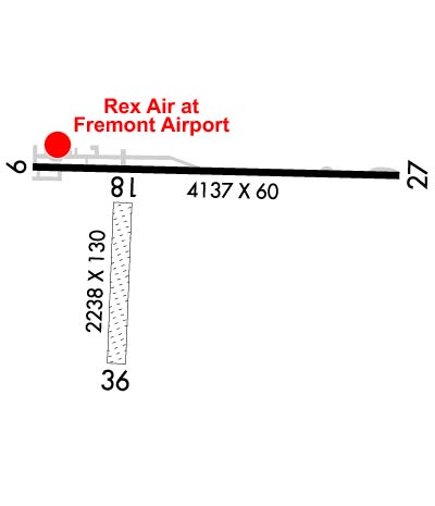
| Lat: N 4120.0 Long: W 08309.7 Elev: 663 Var: +05 Longest Runway: 4137 | ||
| CTAF: 122.8 | ||
| |||||||||||||||||||||||
| |||||||||||||||||||||||
| Rwy | Rwy | |||||||
| 4137x60 | 4011' | 4137x60 | 4137' | |||||
| 2238x130 | 2238' | 2238x130 | 2238' | |||||
| Runway ID | Single Wheel | Double Wheel | Double Tandem Wheel | Dual Double Wheel |
| 09/27 | 13,000 | N/A | N/A | N/A |
| 18/36 | N/A | N/A | N/A | N/A |
| These numbers are Advisory and are not limits. The Airport Manager should have more accurate Weight Limits | ||||
 Airport Diagram might not be current. | |
| Facility Name: | FREMONT |
| City Name: | FREMONT |
| County: | SANDUSKY |
| State abbrev: | OH |
| State Name: | OHIO |
| Ownership: | PRIVATELY OWNED |
| Use: | OPEN TO THE PUBLIC |
| Owner's Name: | FREMONT AIRPORT LLC |
| Address: | 365 S STATE ROUTE 53 |
| FREMONT, OH 43420-9668 | |
| Owner's Phone: | 419-332-8037 |
| Manager's Name: | REX DAMSCHRODER; ADNL CTC MOLLY JOHNSON 419-443-5108. |
| Address: | 365 S STATE ROUTE 53 |
| FREMONT, OH 43420-9668 | |
| Phone: | 419-307-3111 |
| FAA Region: | GREAT LAKES |
| FAA Field Office: | DET |
| Date | Sunrise | Sunset |
|---|---|---|
| 06/08/26 Monday | 5:59 | 21:04 |
| 06/09/26 Tuesday | 5:59 | 21:05 |
| 06/10/26 Wednesday | 5:59 | 21:05 |
| 06/11/26 Thursday | 5:59 | 21:06 |
| 06/12/26 Friday | 5:59 | 21:06 |
| 06/13/26 Saturday | 5:59 | 21:07 |
| 06/14/26 Sunday | 5:59 | 21:07 |
| 06/15/26 Monday | 5:59 | 21:08 |
| 06/16/26 Tuesday | 5:59 | 21:08 |
| 06/17/26 Wednesday | 5:59 | 21:08 |
| 06/18/26 Thursday | 5:59 | 21:09 |
| 06/19/26 Friday | 5:59 | 21:09 |
| 06/20/26 Saturday | 5:59 | 21:09 |
| 06/21/26 Sunday | 5:59 | 21:09 |
| Airport Attendance Schedule | MON-SAT 0900-1600, SUN 1200-1600 |
| Airport Status | OPERATIONAL (This Status can change at any time - please check NOTAMS) |
| Airport Lighting Schedule | ACTVT LIRL RWY 09/27 - 5 SLOW CLICKS CTAF. |
| Airport Storage Available | Tie Downs, Hanger |
| Extra Services Available | Flight Instruction, Aircraft Rental, Aircraft Sales |
| Wind Indicator | YES - (unlit) |
| Control Tower | NO |
| CTAF Frequency | 122.800 |
| Unicom Frequency | 122.800 |
| Rotating Beacon Color | |
| Segmented Circle | NO |
| Landing Fee | NO |
| Airport Inspected | STATE - performed by STATE AERONAUTICAL PERSONNEL |
| Inspection Date | 06/12/2025 |
| Type of Fuel Available | Grade 100LL; -10AFT HRS FUEL 419-307-3111. |
| Airframe Repair Service | MAJOR |
| Power Plant Repair Service | MAJOR |
| Latitude | N4120.0 |
| Longitude | W08309.7 (ESTIMATED) |
| Arpt Elevation | 663ft (SURVEYED) |
| Magnetic Variation | 05W |
| 2 miles SW | of FREMONT |
| Traffic Pattern Altitude | |
| Sectional Chart | DETROIT |
| Operations (Reported) | Yearly | Avg. Daily |
|---|---|---|
| General Aviation Transient | 0 | 0 |
| General Aviation Local | 0 | 0 |
| Air Taxi | 0 | 0 |
| Commerical | 0 | 0 |
| Commuter | 0 | 0 |
| Military | 0 | 0 |
| Aircraft based on Field | |
|---|---|
| General Aviation Singles | 0 |
| General Aviation Multi | 0 |
| Jet Aircraft | 0 |
| General Aviation Helicopters | 0 |
| Military Aircraft | 0 |
| Gliders | 0 |
| Ultralights | 0 |
| FSS on field | NO |
| FSS tie-in | CLEVELAND |
| FSS Phone | 1-800-WX-BRIEF |
| Who issues Notams | CLE |
| Notam D service at airport | YES |
| ARTCC Name | CLEVELAND |
| Airport Certification | |
| Aircraft Rescue & Firefighting Index | None |
| Airport of Entry | No |
| Custom Landing Rights | No |
| Joint Civil/Military | No |
| Military Landing rights | No |
| THIS AIRPORT HAS BEEN SURVEYED BY THE NATIONAL GEODETIC SURVEY. |
| RWY 27 ONLY 3390 FT LGTD. 3900 FT PAVEMENT AVBL DALGT HRS. |
| RWY 27: WHITE LN MARKS RWY END, 330 FT OF PAVEMENT EAST OF LINE FAILED & UNSUITABLE FOR ACFT DUE TO WDSPR SVR CRACKING, DSTNS OVR 3 IN, & WDSPR VEGETATION GROWTH. |
| DEER & BIRDS ON & INVOF ARPT. |
| FOR CD CTC TOLEDO APCH AT 419-865-1495. |
| PUBLD RWY DIMENSIONS DO NOT MATCH PAVEMENT MRKGS. |
| RWY 18/3 6 MOWED 58 FT WIDE. EAST EDGE OF RWY OBSTD BY +60 FT TREES, 50 FT FM CNTRLN, ENTR LEN OF RWY. |
| RWY 09/2 7 OUTER 15 FT EACH SIDE WDSPR CRACKING, LOOSE STONES, & VEGETATION GROWTH; CNTR 30 FT FAIR COND. |
| RWY 27 1 NSTD DUE TO WHITE LN MARKS RWY END. |
Airport Communications & Frequencies:
| ||||||||||||||
| Runway: 09 | Runway: 27 | ||
| Mag heading: | 95° | Mag heading: | 275° |
| Rwy Slope: | .20% Up | Rwy Slope: | -.20% Down |
| Approach: | Approach: | ||
| Pattern: | Left Traffic | Pattern: | Left Traffic |
| Markings: | NONSTANDARD | Markings: | NONSTANDARD |
| Marking Condition: | FAIR; NSTD DUE TO WHITE LN MARKS RWY END & DTHR NOT MKD. | Marking Condition: | POOR; RWY NR FADED. |
| Arresting Dev: | Arresting Dev: | ||
| Lat & Long: | N4120.1 W08310.0 | Lat. & Long.: | N4120.1 W08309.1 |
| Elev: | 652.2 ft. MSL | Elev: | 660.3 ft. MSL |
| TCH: | TCH: | ||
| Visual Glide Path: | Visual Glide Path: | ||
| Displaced Threshold: | 126 feet | Displaced Threshold: | No |
| Touchdown Zone: | YES | Touchdown Zone: | YES |
| Touchdown Elev.: | 662.9 feet | Touchdown Elev.: | 663.2 feet |
| Visual Glide Slope: | Visual Glide Slope: | ||
| RVR Equipment: | RVR Equipment: | ||
| RVV Equipment: | NO | RVV Equipment: | NO |
| Approach Lights: | Approach Lights: | ||
| REIL: | NO | REIL: | NO |
| Centerline Lights: | NO | Centerline Lights: | NO |
| Touchdown lights: | NO | Touchdown lights: | NO |
| Runway Category: | Runway with a Non-precision Approach | Runway Category: | Runway with a Visual Approach |
| Declared Distances: | Declared Distances: | ||
| Obstructions: | ROAD | Obstructions: | TREES |
| Marked: | NOT Marked/Lighted | Marked: | NOT Marked/Lighted |
| Clearance slope: | 1:1 | Clearance slope: | 2:1 |
| Obstruction height: | 16 feet AGL | Obstruction height: | 39 feet AGL |
| Dist. from runway: | 223 feet | Dist. from runway: | 293 feet |
| Centerline offset: | 125 right of centerline | Centerline offset: | 73 feet right of centerline |
| Comments: | 16 FT ROAD, 120 FT DIST, 250 FT L/R. | Comments: | +50 FT TREES, 0 FT DIST, 100 FT L; -15 FT DROP OFF EAST END. EAST 330 FT UNUSBL. |
| Runway: 18 | Runway: 36 | ||
| Mag heading: | 186° | Mag heading: | 6° |
| Rwy Slope: | .12% Up | Rwy Slope: | -.12% Down |
| Approach: | Approach: | ||
| Pattern: | Left Traffic | Pattern: | Left Traffic |
| Markings: | NONE | Markings: | NONE |
| Marking Condition: | Marking Condition: | ||
| Arresting Dev: | Arresting Dev: | ||
| Lat & Long: | N4120.0 W08309.8 | Lat. & Long.: | N4119.7 W08309.8 |
| Elev: | 654.2 ft. MSL | Elev: | 656.9 ft. MSL |
| TCH: | TCH: | ||
| Visual Glide Path: | Visual Glide Path: | ||
| Displaced Threshold: | No | Displaced Threshold: | No |
| Touchdown Zone: | NO | Touchdown Zone: | NO |
| Touchdown Elev.: | Touchdown Elev.: | ||
| Visual Glide Slope: | Visual Glide Slope: | ||
| RVR Equipment: | RVR Equipment: | ||
| RVV Equipment: | NO | RVV Equipment: | NO |
| Approach Lights: | Approach Lights: | ||
| REIL: | NO | REIL: | NO |
| Centerline Lights: | NO | Centerline Lights: | NO |
| Touchdown lights: | NO | Touchdown lights: | NO |
| Runway Category: | Runway with a Visual Approach | Runway Category: | Runway with a Visual Approach |
| Declared Distances: | Declared Distances: | ||
| Obstructions: | TREES | Obstructions: | TREE |
| Marked: | NOT Marked/Lighted | Marked: | NOT Marked/Lighted |
| Clearance slope: | 2:1; +60 TREES, 0 FT DIST, 125 FT L/R. CTLG OBSTN EXCEEDS A 45 DEG SLP. | Clearance slope: | |
| Obstruction height: | 90 feet AGL | Obstruction height: | 60 feet AGL |
| Dist. from runway: | 262 feet; THR OBSTD BY TREES. | Dist. from runway: | 0 feet |
| Centerline offset: | 94 left of centerline | Centerline offset: | 125B |
| Comments: | Comments: |
Thanks for using FltPlan.com
all rights reserved © 1999-2026 by Flight Plan LLC