
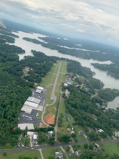
| LAKE NORMAN AIRPARK MOORESVILLE NC |
| |
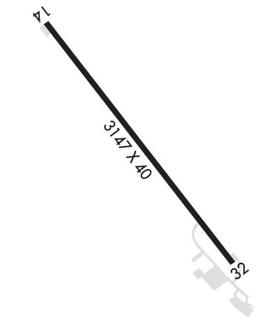
| Lat: N 3536.8 Long: W 08054.0 Elev: 839 Var: +07 Longest Runway: 3147 | ||
| CTAF: 122.8 | ||
| ||||||||||||||||||||||||||||||||||||||||||||
| ||||||||||||||||||||||||||||||||||||||||||||
| Rwy | Rwy | |||||||
| 3147x40 | 2962' | 3147x40 | 3147' | |||||
| Runway ID | Single Wheel | Double Wheel | Double Tandem Wheel | Dual Double Wheel |
| 14/32 | 8,000 | N/A | N/A | N/A |
| These numbers are Advisory and are not limits. The Airport Manager should have more accurate Weight Limits | ||||
 Airport Diagram might not be current. | |
| Facility Name: | LAKE NORMAN AIRPARK |
| City Name: | MOORESVILLE |
| County: | IREDELL |
| State abbrev: | NC |
| State Name: | NORTH CAROLINA |
| Ownership: | PRIVATELY OWNED |
| Use: | OPEN TO THE PUBLIC |
| Owner's Name: | LAKE NORMAN AIRPARK OWNERS ASSOC |
| Address: | 409 NORMANDY ROAD |
| MOORESVILLE, NC 28117-3732 | |
| Owner's Phone: | 704-880-1563 |
| Manager's Name: | DEBBY DENNIS; RACE CITY FLIGHT OPERATIONS - CALL PATRICK LOFVENHOLM 704-662-6227 |
| Address: | 149 YEAGER ROAD |
| MOORESVILLE, NC 28117 | |
| Phone: | 704-880-1563 |
| FAA Region: | SOUTHERN |
| FAA Field Office: | MEM |
| Date | Sunrise | Sunset |
|---|---|---|
| 09/24/21 Friday | 7:13 | 19:18 |
| 09/25/21 Saturday | 7:14 | 19:16 |
| 09/26/21 Sunday | 7:14 | 19:15 |
| 09/27/21 Monday | 7:15 | 19:13 |
| 09/28/21 Tuesday | 7:16 | 19:12 |
| 09/29/21 Wednesday | 7:17 | 19:11 |
| 09/30/21 Thursday | 7:18 | 19:09 |
| 10/01/21 Friday | 7:18 | 19:08 |
| 10/02/21 Saturday | 7:19 | 19:06 |
| 10/03/21 Sunday | 7:20 | 19:05 |
| 10/04/21 Monday | 7:21 | 19:03 |
| 10/05/21 Tuesday | 7:22 | 19:02 |
| 10/06/21 Wednesday | 7:22 | 19:01 |
| 10/07/21 Thursday | 7:23 | 18:59 |
| Airport Attendance Schedule | MON - FRI 0800-1700, SAT - SUN 1000-1600; ARPT UNATNDD ALL MAJ HOLS. |
| Airport Status | OPERATIONAL (This Status can change at any time - please check NOTAMS) |
| Airport Lighting Schedule | ACTVT MIRL RWY 14/32 CTAF. |
| Airport Storage Available | Tie Downs, Hanger |
| Extra Services Available | Flight Instruction, Aircraft Rental |
| Wind Indicator | YES - (unlit) |
| Control Tower | NO |
| CTAF Frequency | 122.800 |
| Unicom Frequency | 122.800 |
| Rotating Beacon Color | CLEAR-GREEN (Light Land Airport) |
| Segmented Circle | YES; UNLGTD SEGMENTED CRC. |
| Landing Fee | NO |
| Airport Inspected | STATE - performed by STATE AERONAUTICAL PERSONNEL |
| Inspection Date | 08/17/2019 |
| Type of Fuel Available | Grade 100LL |
| Airframe Repair Service | MAJOR |
| Power Plant Repair Service | MAJOR |
| Latitude | N3536.8 |
| Longitude | W08054.0 (ESTIMATED) |
| Arpt Elevation | 839ft (SURVEYED) |
| Magnetic Variation | 07W |
| 5 miles NW | of MOORESVILLE |
| Traffic Pattern Altitude | |
| Sectional Chart | CHARLOTTE |
| Operations (Reported) | Yearly | Avg. Daily |
|---|---|---|
| General Aviation Transient | 3000 | 8 |
| General Aviation Local | 15000 | 41 |
| Air Taxi | 0 | 0 |
| Commerical | 0 | 0 |
| Commuter | 0 | 0 |
| Military | 0 | 0 |
| Aircraft based on Field | |
|---|---|
| General Aviation Singles | 86 |
| General Aviation Multi | 3 |
| Jet Aircraft | 0 |
| General Aviation Helicopters | 2 |
| Military Aircraft | 0 |
| Gliders | 0 |
| Ultralights | 1 |
| FSS on field | NO |
| FSS tie-in | RALEIGH |
| FSS Phone | 1-800-WX-BRIEF |
| Who issues Notams | RDU |
| Notam D service at airport | YES |
| ARTCC Name | ATLANTA |
| Airport Certification | |
| Aircraft Rescue & Firefighting Index | None |
| Airport of Entry | No |
| Custom Landing Rights | No |
| Joint Civil/Military | No |
| Military Landing rights | No |
| ACFT TAXIING ON GRASS INVOF RESIDENTIAL AIRPARK HNGR ACCESS. |
| FOR CD CTC APCH AT 704-359-0241. CALL WHEN AT RWY READY FOR DEP. |
| RWY 14 HAS UPHILL GRADE. |
| DEP RWY 14 HEADING 160 DEGS TO AVOID SCHOOL. |
| NOISE SENSITIVE AREA AVOID DEPS BTWN 2300 AND 0600. DEP RWY 32 HEADING 324 DEG UNTIL OVER LAKE TO AVOID HOUSES. |
| RWY 32 HAS 10 FT DROP OFF 5 FT FM LEFT SIDE OF PAVEMENT AND ACFT PARKED 200 FT FM END OF RWY 100 FT RIGHT OF CNTRLN. |
Airport Communications & Frequencies:
| ||||||||||||||
| Runway: 14 | Runway: 32 | ||
| Mag heading: | N/A | Mag heading: | N/A |
| Rwy Slope: | 1.00% Up | Rwy Slope: | -1.00% Down |
| Approach: | Approach: | ||
| Pattern: | Left Traffic | Pattern: | Left Traffic |
| Markings: | NONSTANDARD | Markings: | NONSTANDARD |
| Marking Condition: | GOOD; RWY 14/32 NUMBERS NSTD SIZE. | Marking Condition: | GOOD |
| Arresting Dev: | Arresting Dev: | ||
| Lat & Long: | N3537.0 W08054.2 | Lat. & Long.: | N3536.6 W08053.7 |
| Elev: | 808.0 ft. MSL | Elev: | 839.4 ft. MSL |
| TCH: | TCH: | ||
| Visual Glide Path: | Visual Glide Path: | ||
| Displaced Threshold: | 185 feet | Displaced Threshold: | No |
| Touchdown Zone: | YES | Touchdown Zone: | YES |
| Touchdown Elev.: | 839.0 feet | Touchdown Elev.: | 839.4 feet |
| Visual Glide Slope: | Visual Glide Slope: | ||
| RVR Equipment: | RVR Equipment: | ||
| RVV Equipment: | NO | RVV Equipment: | NO |
| Approach Lights: | Approach Lights: | ||
| REIL: | NO | REIL: | NO |
| Centerline Lights: | NO | Centerline Lights: | NO |
| Touchdown lights: | NO | Touchdown lights: | NO |
| Runway Category: | Runway with a Non-precision Approach | Runway Category: | Runway with a Visual Approach |
| Declared Distances: | Declared Distances: | ||
| Obstructions: | TREES | Obstructions: | TREES |
| Marked: | NOT Marked/Lighted | Marked: | NOT Marked/Lighted |
| Clearance slope: | 6:1; APCH RATIO 9:1 AT DSPLCD THR. | Clearance slope: | 7:1 |
| Obstruction height: | 76 feet AGL | Obstruction height: | 77 feet AGL |
| Dist. from runway: | 720 feet | Dist. from runway: | 792 feet |
| Centerline offset: | 49 left of centerline | Centerline offset: | 226 feet right of centerline |
| Comments: | +10 FT TERRAIN 100 FT FM THR, 50 FT LEFT OF CNTRLN, AND 20 FT SUPPL LDI (TET) 100 FT FM THR, 100 FT LEFT OF CNTRLN. | Comments: | +27 TREES LINE 0-200 FT FM THR OFFSET 121 FT RIGHT. |
Thanks for using FltPlan.com
all rights reserved © 1999-2021 by Flight Plan LLC