
| CLAYTON MUNI CLAYTON AL |
| |
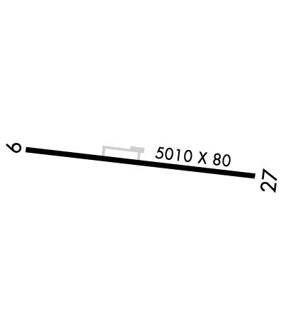
| Lat: N 3153.0 Long: W 08529.1 Elev: 435 Var: +04 Longest Runway: 5010 | ||
| AWOS: 118.77 CTAF: 122.9 | ||
| ||||||||||||||||||||||||||||||||
| ||||||||||||||||||||||||||||||||
| ||||||||||||||||||||||||||||||||
| Rwy | Rwy | |||||||
| 5010x80 | 4732' | 5010x80 | 5010' | |||||
| Runway ID | Single Wheel | Double Wheel | Double Tandem Wheel | Dual Double Wheel |
| 10/28 | N/A | N/A | N/A | N/A |
| These numbers are Advisory and are not limits. The Airport Manager should have more accurate Weight Limits | ||||
 Airport Diagram might not be current. | |
| Facility Name: | CLAYTON MUNI |
| City Name: | CLAYTON |
| County: | BARBOUR |
| State abbrev: | AL |
| State Name: | ALABAMA |
| Ownership: | PUBLICLY OWNED |
| Use: | OPEN TO THE PUBLIC |
| Owner's Name: | CITY OF CLAYTON |
| Address: | PO BOX 385 |
| CLAYTON, AL 36016 | |
| Owner's Phone: | 334-775-9176 |
| Manager's Name: | DARRELL BYRD |
| Address: | 25 ROBERTSON AIRPORT RD. |
| CLAYTON, AL 36016 | |
| Phone: | 334-232-1028 |
| FAA Region: | SOUTHERN |
| FAA Field Office: | JAN |
| Date | Sunrise | Sunset |
|---|---|---|
| 06/07/26 Sunday | 5:36 | 19:46 |
| 06/08/26 Monday | 5:36 | 19:46 |
| 06/09/26 Tuesday | 5:36 | 19:47 |
| 06/10/26 Wednesday | 5:36 | 19:47 |
| 06/11/26 Thursday | 5:36 | 19:48 |
| 06/12/26 Friday | 5:36 | 19:48 |
| 06/13/26 Saturday | 5:36 | 19:48 |
| 06/14/26 Sunday | 5:36 | 19:49 |
| 06/15/26 Monday | 5:36 | 19:49 |
| 06/16/26 Tuesday | 5:36 | 19:49 |
| 06/17/26 Wednesday | 5:36 | 19:50 |
| 06/18/26 Thursday | 5:36 | 19:50 |
| 06/19/26 Friday | 5:36 | 19:50 |
| 06/20/26 Saturday | 5:36 | 19:51 |
| Airport Attendance Schedule | UNATTENDED |
| Airport Status | OPERATIONAL (This Status can change at any time - please check NOTAMS) |
| Airport Lighting Schedule | ACTVT PAPI RWY 10 & 28; REIL RWY 10 & 28; HIRL RWY 10/28 - CTAF. |
| Airport Storage Available | Tie Downs |
| Extra Services Available | NONE |
| Wind Indicator | YES - (lighted) |
| Control Tower | NO |
| CTAF Frequency | 122.900 |
| Unicom Frequency | |
| Rotating Beacon Color | WG |
| Segmented Circle | YES |
| Landing Fee | NO |
| Airport Inspected | STATE - performed by STATE AERONAUTICAL PERSONNEL |
| Inspection Date | 07/01/2025 |
| Type of Fuel Available | None |
| Airframe Repair Service | NONE |
| Power Plant Repair Service | NONE |
| Latitude | N3153.0 |
| Longitude | W08529.1 (ESTIMATED) |
| Arpt Elevation | 434ft (SURVEYED) |
| Magnetic Variation | 04W |
| 2 miles W | of CLAYTON |
| Traffic Pattern Altitude | |
| Sectional Chart | NEW ORLEANS |
| Operations (Reported) | Yearly | Avg. Daily |
|---|---|---|
| General Aviation Transient | 0 | 0 |
| General Aviation Local | 0 | 0 |
| Air Taxi | 0 | 0 |
| Commerical | 0 | 0 |
| Commuter | 0 | 0 |
| Military | 0 | 0 |
| Aircraft based on Field | |
|---|---|
| General Aviation Singles | 0 |
| General Aviation Multi | 0 |
| Jet Aircraft | 0 |
| General Aviation Helicopters | 0 |
| Military Aircraft | 0 |
| Gliders | 0 |
| Ultralights | 0 |
| FSS on field | NO |
| FSS tie-in | ANNISTON |
| FSS Phone | 1-800-WX-BRIEF |
| Who issues Notams | ANB |
| Notam D service at airport | YES |
| ARTCC Name | ATLANTA |
| Airport Certification | |
| Aircraft Rescue & Firefighting Index | None |
| Airport of Entry | No |
| Custom Landing Rights | No |
| Joint Civil/Military | No |
| Military Landing rights | No |
| NATIONAL PLAN OF INTEGRATED AIRPORT SYSTEMS (NPIAS) |
| DEER AND BIRD ACTVTY ON AND INVOF RWY. |
| FOR CD CTC CAIRNS APCH AT 334-255-8402; FOR CD WHEN CAIRNS APCH CLSD CTC ATLANTA ARTCC AT 770-210-7692. |
Airport Communications & Frequencies:
| |||||||||||||||
| Runway: 10 | Runway: 28 | ||
| Mag heading: | 101° | Mag heading: | 281° |
| Rwy Slope: | .25% Up | Rwy Slope: | -.25% Down |
| Approach: | Approach: | ||
| Pattern: | Left Traffic | Pattern: | Left Traffic |
| Markings: | NONPRECISION INSTRUMENT | Markings: | NONPRECISION INSTRUMENT |
| Marking Condition: | FAIR | Marking Condition: | FAIR |
| Arresting Dev: | Arresting Dev: | ||
| Lat & Long: | N3153.0 W08529.6 | Lat. & Long.: | N3153.0 W08528.6 |
| Elev: | 422.0 ft. MSL | Elev: | 434.3 ft. MSL |
| TCH: | 30 ft. AGL | TCH: | 37 ft. AGL |
| Visual Glide Path: | 3.20 degrees | Visual Glide Path: | 3.75 degrees |
| Displaced Threshold: | 278 feet | Displaced Threshold: | No |
| Touchdown Zone: | YES | Touchdown Zone: | YES |
| Touchdown Elev.: | 433.6 feet | Touchdown Elev.: | 434.9 feet |
| Visual Glide Slope: | 2-Light PAPI on LEFT side of Runway | Visual Glide Slope: | 2-Light PAPI on LEFT side of Runway |
| RVR Equipment: | RVR Equipment: | ||
| RVV Equipment: | NO | RVV Equipment: | NO |
| Approach Lights: | Approach Lights: | ||
| REIL: | YES | REIL: | YES |
| Centerline Lights: | NO | Centerline Lights: | NO |
| Touchdown lights: | NO | Touchdown lights: | NO |
| Runway Category: | Runway with a Non-precision Approach having visibility minimums greater than 3/4 mile | Runway Category: | Runway with a Non-precision Approach having visibility minimums greater than 3/4 mile |
| Declared Distances: | Declared Distances: | ||
| Obstructions: | TREE | Obstructions: | TREE |
| Marked: | NOT Marked/Lighted | Marked: | NOT Marked/Lighted |
| Clearance slope: | 17:1; APCH RATIO 19:1 FM DSPLCD THR. | Clearance slope: | 11:1 |
| Obstruction height: | 53 feet AGL | Obstruction height: | 85 feet AGL |
| Dist. from runway: | 1106 feet | Dist. from runway: | 1203 feet |
| Centerline offset: | 178 right of centerline | Centerline offset: | 293 feet right of centerline |
| Comments: | Comments: |
Thanks for using FltPlan.com
all rights reserved © 1999-2026 by Flight Plan LLC
