
| SHELTER COVE SHELTER COVE CA |
| |
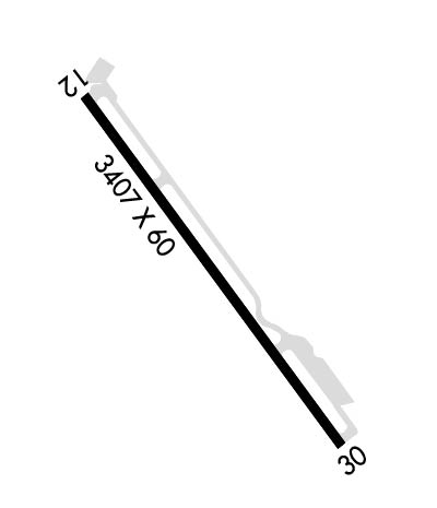
| Lat: N 4001.7 Long: W 12404.5 Elev: 73 Var: -17 Longest Runway: 3407 | ||
| CTAF: 122.9 | ||
| ||
| Rwy | Rwy | |||||||
| 3407x60 | 3301' | 3407x60 | 2906' | |||||
| Runway ID | Single Wheel | Double Wheel | Double Tandem Wheel | Dual Double Wheel |
| 12/30 | 20,000 | N/A | N/A | N/A |
| These numbers are Advisory and are not limits. The Airport Manager should have more accurate Weight Limits | ||||
| FltPlan does not have IFR approach charts available for K0Q5. |
 Airport Diagram might not be current. | |
| Facility Name: | SHELTER COVE |
| City Name: | SHELTER COVE |
| County: | HUMBOLDT |
| State abbrev: | CA |
| State Name: | CALIFORNIA |
| Ownership: | PUBLICLY OWNED |
| Use: | OPEN TO THE PUBLIC |
| Owner's Name: | SHELTER COVE RESORT IMP DISTRICT |
| Address: | 9126 SHELTER COVE ROAD |
| WHITEHORN, CA 95589 | |
| Owner's Phone: | 707-986-7447 |
| Manager's Name: | CHISTOPHER CHRISTIANSON |
| Address: | 9126 SHELTER COVE ROAD |
| WHITEHORN, CA 95589 | |
| Phone: | (707) 986-7447 |
| FAA Region: | WESTERN-PACIFIC |
| FAA Field Office: | SFO |
| Date | Sunrise | Sunset |
|---|---|---|
| 06/07/26 Sunday | 5:48 | 20:43 |
| 06/08/26 Monday | 5:47 | 20:44 |
| 06/09/26 Tuesday | 5:47 | 20:44 |
| 06/10/26 Wednesday | 5:47 | 20:45 |
| 06/11/26 Thursday | 5:47 | 20:45 |
| 06/12/26 Friday | 5:47 | 20:46 |
| 06/13/26 Saturday | 5:47 | 20:46 |
| 06/14/26 Sunday | 5:47 | 20:46 |
| 06/15/26 Monday | 5:47 | 20:47 |
| 06/16/26 Tuesday | 5:47 | 20:47 |
| 06/17/26 Wednesday | 5:47 | 20:48 |
| 06/18/26 Thursday | 5:47 | 20:48 |
| 06/19/26 Friday | 5:47 | 20:48 |
| 06/20/26 Saturday | 5:47 | 20:48 |
| Airport Attendance Schedule | UNATTENDED |
| Airport Status | OPERATIONAL (This Status can change at any time - please check NOTAMS) |
| Airport Lighting Schedule | |
| Airport Storage Available | Tie Downs |
| Extra Services Available | NONE |
| Wind Indicator | YES - (unlit) |
| Control Tower | NO |
| CTAF Frequency | 122.900 |
| Unicom Frequency | |
| Rotating Beacon Color | |
| Segmented Circle | YES |
| Landing Fee | NO |
| Airport Inspected | STATE - performed by STATE AERONAUTICAL PERSONNEL |
| Inspection Date | 10/17/2025 |
| Type of Fuel Available | None |
| Airframe Repair Service | NONE |
| Power Plant Repair Service | NONE |
| Latitude | N4001.7 |
| Longitude | W12404.5 (ESTIMATED) |
| Arpt Elevation | 73ft (SURVEYED) |
| Magnetic Variation | 17E |
| 1 miles W | of SHELTER COVE |
| Traffic Pattern Altitude | |
| Sectional Chart | KLAMATH FALLS |
| Operations (Reported) | Yearly | Avg. Daily |
|---|---|---|
| General Aviation Transient | 0 | 0 |
| General Aviation Local | 0 | 0 |
| Air Taxi | 0 | 0 |
| Commerical | 0 | 0 |
| Commuter | 0 | 0 |
| Military | 0 | 0 |
| Aircraft based on Field | |
|---|---|
| General Aviation Singles | 0 |
| General Aviation Multi | 0 |
| Jet Aircraft | 0 |
| General Aviation Helicopters | 0 |
| Military Aircraft | 0 |
| Gliders | 0 |
| Ultralights | 0 |
| FSS on field | NO |
| FSS tie-in | OAKLAND |
| FSS Phone | 1-800-WX-BRIEF |
| Who issues Notams | OAK |
| Notam D service at airport | YES |
| ARTCC Name | OAKLAND |
| Airport Certification | |
| Aircraft Rescue & Firefighting Index | None |
| Airport of Entry | No |
| Custom Landing Rights | No |
| Joint Civil/Military | No |
| Military Landing rights | No |
| NATIONAL PLAN OF INTEGRATED AIRPORT SYSTEMS (NPIAS) |
| ARPT USE RESTRICTED BY AMGR TO ACFT HAVING A MAXIMUM CERTIFICATED GROSS TKOF WGT OF 12,500 LBS OR LESS; CTC AMGR FOR ADDITIONAL INFO (707)986-7447. |
| STUDENT PILOT SOLO FLIGHTS PROHIBITED. |
| NO PRACTICE LOW APCHS OR TOUCH AND GO LANDINGS. |
| BE ALERT FOR ULTRA-LIGHTS, HANGLIDERS AND PARACHUTERS INVOF ARPT. |
| GOLF CARTS OPERATING ON AND INVOF ARPT. |
| EXPECT CROSSWINDS, DOWNDRAFTS AND EXTDD PERIODS OF FOG YEAR-ROUND. |
| TERRAIN +40 FT DROP OFF LCTD 500 FT NORTH RY 12 END. |
| FOR CD CTC OAKLAND ARTCC AT 510-745-3380. |
| Runway: 12 | Runway: 30 | ||
| Mag heading: | N/A | Mag heading: | N/A |
| Rwy Slope: | -.54% Down | Rwy Slope: | .54% Up |
| Approach: | Approach: | ||
| Pattern: | Right Traffic | Pattern: | Left Traffic |
| Markings: | BASIC | Markings: | BASIC |
| Marking Condition: | FAIR | Marking Condition: | GOOD |
| Arresting Dev: | Arresting Dev: | ||
| Lat & Long: | N4001.9 W12404.7 | Lat. & Long.: | N4001.5 W12404.2 |
| Elev: | 73.3 ft. MSL | Elev: | 54.9 ft. MSL |
| TCH: | TCH: | ||
| Visual Glide Path: | Visual Glide Path: | ||
| Displaced Threshold: | 106 feet | Displaced Threshold: | 501 feet |
| Touchdown Zone: | YES | Touchdown Zone: | YES |
| Touchdown Elev.: | 73.3 feet | Touchdown Elev.: | 73.3 feet |
| Visual Glide Slope: | Visual Glide Slope: | ||
| RVR Equipment: | RVR Equipment: | ||
| RVV Equipment: | NO | RVV Equipment: | NO |
| Approach Lights: | Approach Lights: | ||
| REIL: | NO | REIL: | NO |
| Centerline Lights: | NO | Centerline Lights: | NO |
| Touchdown lights: | NO | Touchdown lights: | NO |
| Runway Category: | Runway with a Visual Approach | Runway Category: | Runway with a Visual Approach |
| Declared Distances: | Declared Distances: | ||
| Obstructions: | TREE | Obstructions: | TREE |
| Marked: | NOT Marked/Lighted | Marked: | NOT Marked/Lighted |
| Clearance slope: | 20:1 | Clearance slope: | 13:1; APCH RATIO 22:1 TO DSPLCD THLD, 37 FT TREE 191 FT R 341 FT FM EOR.. |
| Obstruction height: | 10 feet AGL | Obstruction height: | 60 feet AGL |
| Dist. from runway: | 400 feet | Dist. from runway: | 1000 feet |
| Centerline offset: | 150 left of centerline | Centerline offset: | 190 feet right of centerline |
| Comments: | Comments: |
Thanks for using FltPlan.com
all rights reserved © 1999-2026 by Flight Plan LLC
