
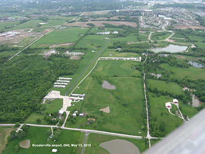
| ROOSTERVILLE LIBERTY MO |
| |
| Lat: N 3917.4 Long: W 09426.5 Elev: 1004 Var: -05 Longest Runway: 2780 | ||
| CTAF: 122.8 | ||
| ||||||||||||||||||||||||||||||||
| ||||||||||||||||||||||||||||||||
| Rwy | Rwy | |||||||
| 2780x20 | 2780' | 2780x20 | 2780' | |||||
| Runway ID | Single Wheel | Double Wheel | Double Tandem Wheel | Dual Double Wheel |
| 18/36 | N/A | N/A | N/A | N/A |
| These numbers are Advisory and are not limits. The Airport Manager should have more accurate Weight Limits | ||||
| FltPlan does not have IFR approach charts available for K0N0. |
| Facility Name: | ROOSTERVILLE |
| City Name: | LIBERTY |
| County: | CLAY |
| State abbrev: | MO |
| State Name: | MISSOURI |
| Ownership: | PRIVATELY OWNED |
| Use: | OPEN TO THE PUBLIC |
| Owner's Name: | AIRE KARE INC |
| Address: | 11001 NE 112TH ST. |
| KANSAS CITY, MO 64157 | |
| Owner's Phone: | 816-781-7194 |
| Manager's Name: | PAUL STUBER |
| Address: | 11001 NE 112TH ST. |
| KANSAS CITY, MO 64057 | |
| Phone: | 816-781-7194 |
| FAA Region: | CENTRAL |
| FAA Field Office: | NONE |
| Date | Sunrise | Sunset |
|---|---|---|
| 09/24/21 Friday | 7:07 | 19:12 |
| 09/25/21 Saturday | 7:08 | 19:10 |
| 09/26/21 Sunday | 7:09 | 19:09 |
| 09/27/21 Monday | 7:10 | 19:07 |
| 09/28/21 Tuesday | 7:11 | 19:05 |
| 09/29/21 Wednesday | 7:12 | 19:04 |
| 09/30/21 Thursday | 7:13 | 19:02 |
| 10/01/21 Friday | 7:14 | 19:01 |
| 10/02/21 Saturday | 7:15 | 18:59 |
| 10/03/21 Sunday | 7:16 | 18:57 |
| 10/04/21 Monday | 7:16 | 18:56 |
| 10/05/21 Tuesday | 7:17 | 18:54 |
| 10/06/21 Wednesday | 7:18 | 18:53 |
| 10/07/21 Thursday | 7:19 | 18:51 |
| Airport Attendance Schedule | 7 Days A Week 0800-DUSK; FOR ATTENDANT OTHER HRS CALL 816-781-4326. |
| Airport Status | OPERATIONAL (This Status can change at any time - please check NOTAMS) |
| Airport Lighting Schedule | ACTVT MIRL RY 18/36 - CTAF. |
| Airport Storage Available | Tie Downs |
| Extra Services Available | Flight Instruction, Aircraft Rental |
| Wind Indicator | YES - (unlit) |
| Control Tower | NO |
| CTAF Frequency | 122.800 |
| Unicom Frequency | 122.800 |
| Rotating Beacon Color | |
| Segmented Circle | NO |
| Landing Fee | NO |
| Airport Inspected | STATE - performed by STATE AERONAUTICAL PERSONNEL |
| Inspection Date | 06/29/2021 |
| Type of Fuel Available | Grade 100LL |
| Airframe Repair Service | MAJOR |
| Power Plant Repair Service | MAJOR |
| Latitude | N3917.4 |
| Longitude | W09426.5 (ESTIMATED) |
| Arpt Elevation | 1004ft (SURVEYED) |
| Magnetic Variation | 05E |
| 3 miles NW | of LIBERTY |
| Traffic Pattern Altitude | |
| Sectional Chart | KANSAS CITY |
| Operations (Reported) | Yearly | Avg. Daily |
|---|---|---|
| General Aviation Transient | 620 | 2 |
| General Aviation Local | 7000 | 19 |
| Air Taxi | 0 | 0 |
| Commerical | 0 | 0 |
| Commuter | 0 | 0 |
| Military | 0 | 0 |
| Aircraft based on Field | |
|---|---|
| General Aviation Singles | 63 |
| General Aviation Multi | 2 |
| Jet Aircraft | 0 |
| General Aviation Helicopters | 0 |
| Military Aircraft | 0 |
| Gliders | 0 |
| Ultralights | 0 |
| FSS on field | NO |
| FSS tie-in | COLUMBIA |
| FSS Phone | 1-800-WX-BRIEF |
| Who issues Notams | COU |
| Notam D service at airport | YES |
| ARTCC Name | KANSAS CITY |
| Airport Certification | |
| Aircraft Rescue & Firefighting Index | None |
| Airport of Entry | No |
| Custom Landing Rights | No |
| Joint Civil/Military | No |
| Military Landing rights | No |
| WILDLIFE ON & INVOF RY ESPECIALLY EARLY MORNING HRS. |
| NSTD RY SAFETY AREAS BEYOND BOTH RY ENDS; RY 18 END LARGE DROP OFF; RY 36 HAS 4 FT FENCE 15 FT FM RY END. |
| FOR CD CTC KANSAS CITY APCH AT 816-329-2710. |
| RWY 18/3 6 FIRST 50 FT ON NORTH END STEEP SLOPE; RY ALNMT CROOKED. |
| RWY 18/3 6 NSTD MIRL; LGTS 40-50 FT LEFT & RIGHT OF CNTRLN AT 100 FT DSTCS ON WEST SIDE; VARIOUS DSTCS ON EAST SIDE; 2 RED THLD LGTS AT EACH THLD. |
| Runway: 18 | Runway: 36 | ||
| Mag heading: | N/A | Mag heading: | N/A |
| Rwy Slope: | .04% Up | Rwy Slope: | -.04% Down |
| Approach: | Approach: | ||
| Pattern: | Left Traffic | Pattern: | Left Traffic |
| Markings: | NONSTANDARD | Markings: | NONSTANDARD |
| Marking Condition: | GOOD; RWY 18 NSTD NPI MARKINGS; SMALL NR DESIGNATIONS, THLD MARKINGS, & DASHED CNTRLN. | Marking Condition: | GOOD; RWY 36 NSTD BASIC MARKINGS; SMALL NR DESIGNATIONS & DASHED CNTRLN. |
| Arresting Dev: | Arresting Dev: | ||
| Lat & Long: | N3917.6 W09426.5 | Lat. & Long.: | N3917.2 W09426.6 |
| Elev: | 1003.0 ft. MSL | Elev: | 1004.0 ft. MSL |
| TCH: | TCH: | ||
| Visual Glide Path: | Visual Glide Path: | ||
| Displaced Threshold: | No | Displaced Threshold: | No |
| Touchdown Zone: | NO | Touchdown Zone: | NO |
| Touchdown Elev.: | Touchdown Elev.: | ||
| Visual Glide Slope: | Visual Glide Slope: | ||
| RVR Equipment: | RVR Equipment: | ||
| RVV Equipment: | NO | RVV Equipment: | NO |
| Approach Lights: | Approach Lights: | ||
| REIL: | NO | REIL: | NO |
| Centerline Lights: | NO | Centerline Lights: | NO |
| Touchdown lights: | NO | Touchdown lights: | NO |
| Runway Category: | Runway with a Visual Approach | Runway Category: | Runway with a Visual Approach |
| Declared Distances: | Declared Distances: | ||
| Obstructions: | TREES | Obstructions: | TREES |
| Marked: | NOT Marked/Lighted | Marked: | NOT Marked/Lighted |
| Clearance slope: | 4:1 | Clearance slope: | 10:1 |
| Obstruction height: | 62 feet AGL | Obstruction height: | 26 feet AGL |
| Dist. from runway: | 505 feet | Dist. from runway: | 482 feet |
| Centerline offset: | 150 right of centerline | Centerline offset: | 150 feet right of centerline |
| Comments: | RWY 18 1-20 FT GND; BLDGS & AUTO PARKING AREA 0-200 FT FM RY END, 10-125 FT R. | Comments: | RWY 36 +1-4 FT GND & FC 25-30 FT FROM RY END L & R. |
Thanks for using FltPlan.com
all rights reserved © 1999-2021 by Flight Plan LLC