
| BILLY FREE MUNI DUMAS AR |
| |
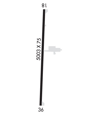
| Lat: N 3353.1 Long: W 09132.1 Elev: 164 Var: -01 Longest Runway: 5003 | ||
| CTAF: 122.8 | ||
| |||||||||||||||||||||||
| |||||||||||||||||||||||
| Rwy | Rwy | |||||||
| 5003x75 | 5003' | 5003x75 | 5003' | |||||
| Runway ID | Single Wheel | Double Wheel | Double Tandem Wheel | Dual Double Wheel |
| 18/36 | 15,000 | N/A | N/A | N/A |
| These numbers are Advisory and are not limits. The Airport Manager should have more accurate Weight Limits | ||||
 Airport Diagram might not be current. | |
| Facility Name: | BILLY FREE MUNI |
| City Name: | DUMAS |
| County: | DESHA |
| State abbrev: | AR |
| State Name: | ARKANSAS |
| Ownership: | PUBLICLY OWNED |
| Use: | OPEN TO THE PUBLIC |
| Owner's Name: | CITY OF DUMAS |
| Address: | PO BOX 157 |
| DUMAS, AR 71639 | |
| Owner's Phone: | 870-382-2121 |
| Manager's Name: | BRANNON WEST |
| Address: | 202 BURNS RD |
| DUMAS, AR 71639 | |
| Phone: | 870-382-2216 |
| FAA Region: | SOUTHWEST |
| FAA Field Office: | AOK |
| Date | Sunrise | Sunset |
|---|---|---|
| 06/08/26 Monday | 5:55 | 20:16 |
| 06/09/26 Tuesday | 5:55 | 20:16 |
| 06/10/26 Wednesday | 5:55 | 20:17 |
| 06/11/26 Thursday | 5:55 | 20:17 |
| 06/12/26 Friday | 5:55 | 20:17 |
| 06/13/26 Saturday | 5:55 | 20:18 |
| 06/14/26 Sunday | 5:55 | 20:18 |
| 06/15/26 Monday | 5:55 | 20:19 |
| 06/16/26 Tuesday | 5:55 | 20:19 |
| 06/17/26 Wednesday | 5:55 | 20:19 |
| 06/18/26 Thursday | 5:55 | 20:19 |
| 06/19/26 Friday | 5:55 | 20:20 |
| 06/20/26 Saturday | 5:55 | 20:20 |
| 06/21/26 Sunday | 5:56 | 20:20 |
| Airport Attendance Schedule | MON-FRI 0800-1700; FOR ARPT ATTENDANT AFT HRS CALL 870-299-3861. |
| Airport Status | OPERATIONAL (This Status can change at any time - please check NOTAMS) |
| Airport Lighting Schedule | ACTVT PAPI RWY 36; MIRL RWY 18/36 - CTAF. |
| Airport Storage Available | Tie Downs, Hanger |
| Extra Services Available | Crop Dusting |
| Wind Indicator | YES - (lighted) |
| Control Tower | NO |
| CTAF Frequency | 122.800 |
| Unicom Frequency | 122.800 |
| Rotating Beacon Color | WG; BCN TEMP OTS |
| Segmented Circle | YES |
| Landing Fee | NO |
| Airport Inspected | STATE - performed by STATE AERONAUTICAL PERSONNEL |
| Inspection Date | 10/26/2023 |
| Type of Fuel Available | Grade 100LL, JET A (freeze point -40C); -10SELF SVC FUEL AVBL 24 HRS WITH CREDIT CARD (100LL & JET A) |
| Airframe Repair Service | MAJOR |
| Power Plant Repair Service | MAJOR |
| Latitude | N3353.1 |
| Longitude | W09132.1 (ESTIMATED) |
| Arpt Elevation | 164ft (SURVEYED) |
| Magnetic Variation | 01E |
| 2 miles W | of DUMAS |
| Traffic Pattern Altitude | |
| Sectional Chart | MEMPHIS |
| Operations (Reported) | Yearly | Avg. Daily |
|---|---|---|
| General Aviation Transient | 0 | 0 |
| General Aviation Local | 0 | 0 |
| Air Taxi | 0 | 0 |
| Commerical | 0 | 0 |
| Commuter | 0 | 0 |
| Military | 0 | 0 |
| Aircraft based on Field | |
|---|---|
| General Aviation Singles | 0 |
| General Aviation Multi | 0 |
| Jet Aircraft | 0 |
| General Aviation Helicopters | 0 |
| Military Aircraft | 0 |
| Gliders | 0 |
| Ultralights | 0 |
| FSS on field | NO |
| FSS tie-in | JONESBORO |
| FSS Phone | 1-800-WX-BRIEF |
| Who issues Notams | JBR |
| Notam D service at airport | YES |
| ARTCC Name | MEMPHIS |
| Airport Certification | |
| Aircraft Rescue & Firefighting Index | None |
| Airport of Entry | No |
| Custom Landing Rights | No |
| Joint Civil/Military | No |
| Military Landing rights | YES |
| NATIONAL PLAN OF INTEGRATED AIRPORT SYSTEMS (NPIAS) |
| GRANT AGREEMENTS UNDER FAAP/ADAP/AIP |
| ASSURANCES PURSUANT TO TITLE VI, CIVIL RIGHTS ACT OF 1964 |
| MIGRATORY BIRDS ON AND INVOF ARPT NOV-FEB. |
| FOR CD CTC MEMPHIS ARTCC AT 901-368-8453/8449. |
Airport Communications & Frequencies:
| |||||||||
| Runway: 18 | Runway: 36 | ||
| Mag heading: | 181° | Mag heading: | 1° |
| Rwy Slope: | -.01% Down | Rwy Slope: | .01% Up |
| Approach: | Approach: | ||
| Pattern: | Left Traffic | Pattern: | Left Traffic |
| Markings: | BASIC | Markings: | NONPRECISION INSTRUMENT |
| Marking Condition: | FAIR | Marking Condition: | FAIR |
| Arresting Dev: | Arresting Dev: | ||
| Lat & Long: | N3353.5 W09132.0 | Lat. & Long.: | N3352.7 W09132.1 |
| Elev: | 163.8 ft. MSL | Elev: | 163.2 ft. MSL |
| TCH: | TCH: | 40 ft. AGL | |
| Visual Glide Path: | Visual Glide Path: | 3.00 degrees | |
| Displaced Threshold: | No | Displaced Threshold: | No |
| Touchdown Zone: | YES | Touchdown Zone: | YES |
| Touchdown Elev.: | 164.2 feet | Touchdown Elev.: | 164.2 feet |
| Visual Glide Slope: | Visual Glide Slope: | 2-Light PAPI on LEFT side of Runway | |
| RVR Equipment: | RVR Equipment: | ||
| RVV Equipment: | NO | RVV Equipment: | NO |
| Approach Lights: | Approach Lights: | ||
| REIL: | NO | REIL: | NO |
| Centerline Lights: | NO | Centerline Lights: | NO |
| Touchdown lights: | NO | Touchdown lights: | NO |
| Runway Category: | Runway with a Visual Approach | Runway Category: | Runway with a Non-precision Approach |
| Declared Distances: | Declared Distances: |
Thanks for using FltPlan.com
all rights reserved © 1999-2026 by Flight Plan LLC

