
| HEADLAND MUNI HEADLAND AL |
| |
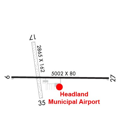
| Lat: N 3121.8 Long: W 08518.8 Elev: 359 Var: +03 Longest Runway: 5002 | ||
| CTAF: 122.9 | ||
| ||||||
|
| Rwy | Rwy | |||||||
| 5002x80 | 5002' | 5002x80 | 5002' | |||||
| 2865x162 | 2865' | 2865x162 | 2865' | |||||
| Runway ID | Single Wheel | Double Wheel | Double Tandem Wheel | Dual Double Wheel |
| 09/27 | 12,000 | N/A | N/A | N/A |
| 17/35 | N/A | N/A | N/A | N/A |
| These numbers are Advisory and are not limits. The Airport Manager should have more accurate Weight Limits | ||||
| FltPlan does not have IFR approach charts available for K0J6. |
 Airport Diagram might not be current. | |
| Facility Name: | HEADLAND MUNI |
| City Name: | HEADLAND |
| County: | HENRY |
| State abbrev: | AL |
| State Name: | ALABAMA |
| Ownership: | PUBLICLY OWNED |
| Use: | OPEN TO THE PUBLIC |
| Owner's Name: | CITY OF HEADLAND |
| Address: | 9 PARK STREET |
| HEADLAND, AL 36345 | |
| Owner's Phone: | 334-693-3365 |
| Manager's Name: | PETE CREWS |
| Address: | P.O. BOX 128 |
| HEADLAND, AL 36345 | |
| Phone: | 334-693-9415; 850-210-2908 |
| FAA Region: | SOUTHERN |
| FAA Field Office: | JAN |
| Date | Sunrise | Sunset |
|---|---|---|
| 01/26/22 Wednesday | 6:37 | 17:11 |
| 01/27/22 Thursday | 6:37 | 17:12 |
| 01/28/22 Friday | 6:36 | 17:13 |
| 01/29/22 Saturday | 6:36 | 17:14 |
| 01/30/22 Sunday | 6:35 | 17:14 |
| 01/31/22 Monday | 6:35 | 17:15 |
| 02/01/22 Tuesday | 6:34 | 17:16 |
| 02/02/22 Wednesday | 6:33 | 17:17 |
| 02/03/22 Thursday | 6:33 | 17:18 |
| 02/04/22 Friday | 6:32 | 17:19 |
| 02/05/22 Saturday | 6:31 | 17:20 |
| 02/06/22 Sunday | 6:31 | 17:21 |
| 02/07/22 Monday | 6:30 | 17:22 |
| 02/08/22 Tuesday | 6:29 | 17:22 |
| Airport Attendance Schedule | MON - FRI 0800 - 1700, SAT - SUN UNATTENDED |
| Airport Status | OPERATIONAL (This Status can change at any time - please check NOTAMS) |
| Airport Lighting Schedule | ACTVT REIL RWY 09 & 27; PAPI RWY 09 & 27; MIRL RWY 09/27 - CTAF. |
| Airport Storage Available | Tie Downs |
| Extra Services Available | Crop Dusting, Flight Instruction, Aircraft Rental |
| Wind Indicator | YES - (lighted) |
| Control Tower | NO |
| CTAF Frequency | 122.900 |
| Unicom Frequency | |
| Rotating Beacon Color | CLEAR-GREEN (Light Land Airport) |
| Segmented Circle | YES |
| Landing Fee | NO |
| Airport Inspected | STATE - performed by STATE AERONAUTICAL PERSONNEL |
| Inspection Date | 01/18/2019 |
| Type of Fuel Available | Grade 100LL, JET A (freeze point -40C); -10FUEL 24 HR CREDIT CARD SVC AVBL. |
| Airframe Repair Service | None |
| Power Plant Repair Service | None |
| Latitude | N3121.8 |
| Longitude | W08518.8 (ESTIMATED) |
| Arpt Elevation | 358ft (SURVEYED) |
| Magnetic Variation | 03W |
| 2 miles NE | of HEADLAND |
| Traffic Pattern Altitude | |
| Sectional Chart | NEW ORLEANS |
| Operations (Reported) | Yearly | Avg. Daily |
|---|---|---|
| General Aviation Transient | 31667 | 87 |
| General Aviation Local | 5536 | 15 |
| Air Taxi | 0 | 0 |
| Commerical | 0 | 0 |
| Commuter | 0 | 0 |
| Military | 4000 | 11 |
| Aircraft based on Field | |
|---|---|
| General Aviation Singles | 31 |
| General Aviation Multi | 6 |
| Jet Aircraft | 0 |
| General Aviation Helicopters | 0 |
| Military Aircraft | 0 |
| Gliders | 0 |
| Ultralights | 0 |
| FSS on field | NO |
| FSS tie-in | ANNISTON |
| FSS Phone | 1-800-WX-BRIEF |
| Who issues Notams | ANB |
| Notam D service at airport | YES |
| ARTCC Name | JACKSONVILLE |
| Airport Certification | |
| Aircraft Rescue & Firefighting Index | None |
| Airport of Entry | No |
| Custom Landing Rights | No |
| Joint Civil/Military | No |
| Military Landing rights | YES |
| NATIONAL PLAN OF INTEGRATED AIRPORT SYSTEMS (NPIAS) |
| GRANT AGREEMENTS UNDER FAAP/ADAP/AIP |
| SURPLUS PROPERTY AGREEMENT UNDER REGULATION 16-WAA |
| ASSURANCES PURSUANT TO TITLE VI, CIVIL RIGHTS ACT OF 1964 |
| TWY LGTS FOR APRON TURNOFF ONLY. |
| FOR CD CTC CAIRNS APCH AT 334-255-8402, WHEN APCH CLSD CTC JACKSONVILLE ARTCC AT 904-845-1592. |
| RWY 35 FARM EQPT AND ACFT PARKED CLOSE TO RWY THR. |
| RWY 17/3 5 +2 INCH LIP WHERE RWY INTERSECTS RWY 09/27. |
Airport Communications & Frequencies:
| |||||||||||
| Runway: 09 | Runway: 27 | ||
| Mag heading: | 94° | Mag heading: | 274° |
| Rwy Slope: | .03% Up | Rwy Slope: | -.03% Down |
| Approach: | Approach: | ||
| Pattern: | Left Traffic | Pattern: | Left Traffic |
| Markings: | NONPRECISION INSTRUMENT | Markings: | NONPRECISION INSTRUMENT |
| Marking Condition: | FAIR | Marking Condition: | FAIR |
| Arresting Dev: | Arresting Dev: | ||
| Lat & Long: | N3121.8 W08519.1 | Lat. & Long.: | N3121.8 W08518.2 |
| Elev: | 353.8 ft. MSL | Elev: | 355.1 ft. MSL |
| TCH: | 40 ft. AGL | TCH: | 40 ft. AGL |
| Visual Glide Path: | 3.00 degrees | Visual Glide Path: | 3.50 degrees |
| Displaced Threshold: | No | Displaced Threshold: | No |
| Touchdown Zone: | YES | Touchdown Zone: | YES |
| Touchdown Elev.: | 356.8 feet | Touchdown Elev.: | 358.6 feet |
| Visual Glide Slope: | 2-Light PAPI on LEFT side of Runway | Visual Glide Slope: | 2-Light PAPI on LEFT side of Runway |
| RVR Equipment: | RVR Equipment: | ||
| RVV Equipment: | NO | RVV Equipment: | NO |
| Approach Lights: | Approach Lights: | ||
| REIL: | YES | REIL: | YES |
| Centerline Lights: | NO | Centerline Lights: | NO |
| Touchdown lights: | NO | Touchdown lights: | NO |
| Runway Category: | Runway with a Non-precision Approach | Runway Category: | Runway with a Non-precision Approach |
| Declared Distances: | Declared Distances: | ||
| Obstructions: | PLINE | Obstructions: | TREE |
| Marked: | NOT Marked/Lighted | Marked: | NOT Marked/Lighted |
| Clearance slope: | 32:1 | Clearance slope: | 18:1 |
| Obstruction height: | 28 feet AGL | Obstruction height: | 75 feet AGL |
| Dist. from runway: | 1123 feet | Dist. from runway: | 1569 feet |
| Centerline offset: | 66 right of centerline | Centerline offset: | 12 feet right of centerline |
| Comments: | Comments: |
| Runway: 17 | Runway: 35 | ||
| Mag heading: | 178° | Mag heading: | 358° |
| Rwy Slope: | .02% Up | Rwy Slope: | -.02% Down |
| Approach: | Approach: | ||
| Pattern: | Left Traffic | Pattern: | Left Traffic |
| Markings: | Markings: | ||
| Marking Condition: | Marking Condition: | ||
| Arresting Dev: | Arresting Dev: | ||
| Lat & Long: | N3122.1 W08518.9 | Lat. & Long.: | N3121.7 W08518.9 |
| Elev: | 355.7 ft. MSL | Elev: | 356.2 ft. MSL |
| TCH: | TCH: | ||
| Visual Glide Path: | Visual Glide Path: | ||
| Displaced Threshold: | No | Displaced Threshold: | No |
| Touchdown Zone: | YES | Touchdown Zone: | YES |
| Touchdown Elev.: | 355.7 feet | Touchdown Elev.: | 355.7 feet |
| Visual Glide Slope: | Visual Glide Slope: | ||
| RVR Equipment: | RVR Equipment: | ||
| RVV Equipment: | NO | RVV Equipment: | NO |
| Approach Lights: | Approach Lights: | ||
| REIL: | NO | REIL: | NO |
| Centerline Lights: | NO | Centerline Lights: | NO |
| Touchdown lights: | NO | Touchdown lights: | NO |
| Runway Category: | Runway with a Visual Approach | Runway Category: | Runway with a Visual Approach |
| Declared Distances: | Declared Distances: |
Thanks for using FltPlan.com
all rights reserved © 1999-2022 by Flight Plan LLC
