
| FINGER LAKES RGNL SENECA FALLS NY |
| |
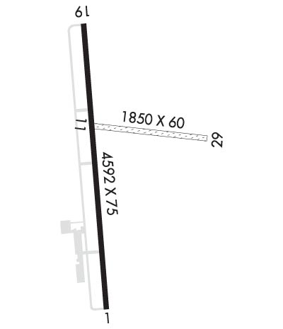
| Lat: N 4253.0 Long: W 07646.9 Elev: 492 Var: +12 Longest Runway: 4592 | ||
| AWOS: 120.0 CTAF: 122.8 | ||
| ||||||||||||||||||||||||||||||||||||||||||||
| ||||||||||||||||||||||||||||||||||||||||||||
| ||||||||||||||||||||||||||||||||||||||||||||
| Rwy | Rwy | |||||||
| 4592x75 | 4200' | 4592x75 | 4592' | |||||
| 1850x60 | 1850' | 1850x60 | 1850' | |||||
| Runway ID | Single Wheel | Double Wheel | Double Tandem Wheel | Dual Double Wheel |
| 01/19 | 12,500 | 30,000 | N/A | N/A |
| 11/29 | N/A | N/A | N/A | N/A |
| These numbers are Advisory and are not limits. The Airport Manager should have more accurate Weight Limits | ||||
 Airport Diagram might not be current. | |
| Facility Name: | FINGER LAKES RGNL |
| City Name: | SENECA FALLS |
| County: | SENECA |
| State abbrev: | NY |
| State Name: | NEW YORK |
| Ownership: | PUBLICLY OWNED |
| Use: | OPEN TO THE PUBLIC |
| Owner's Name: | SENECA COUNTY |
| Address: | 1 DEPRONIO DR |
| WATERLOO, NY 13165 | |
| Owner's Phone: | 315-539-5655 |
| Manager's Name: | DAVID HAIMES |
| Address: | 2727 MARTIN RD |
| SENECA FALLS, NY 13148 | |
| Phone: | 315-568-0110 |
| FAA Region: | EASTERN |
| FAA Field Office: | NYC |
| Date | Sunrise | Sunset |
|---|---|---|
| 09/24/21 Friday | 6:56 | 19:01 |
| 09/25/21 Saturday | 6:57 | 19:00 |
| 09/26/21 Sunday | 6:58 | 18:58 |
| 09/27/21 Monday | 7:00 | 18:56 |
| 09/28/21 Tuesday | 7:01 | 18:54 |
| 09/29/21 Wednesday | 7:02 | 18:52 |
| 09/30/21 Thursday | 7:03 | 18:51 |
| 10/01/21 Friday | 7:04 | 18:49 |
| 10/02/21 Saturday | 7:05 | 18:47 |
| 10/03/21 Sunday | 7:06 | 18:45 |
| 10/04/21 Monday | 7:07 | 18:44 |
| 10/05/21 Tuesday | 7:09 | 18:42 |
| 10/06/21 Wednesday | 7:10 | 18:40 |
| 10/07/21 Thursday | 7:11 | 18:38 |
| Airport Attendance Schedule | MON-FRI 0800-1600, SAT-SUN 0800-1500 |
| Airport Status | OPERATIONAL (This Status can change at any time - please check NOTAMS) |
| Airport Lighting Schedule | ACTVT REIL RWY 01 & 19; MIRL RWY 01/19 - CTAF. |
| Airport Storage Available | Tie Downs, Hanger |
| Extra Services Available | Air Freight, Flight Instruction |
| Wind Indicator | YES - (lighted) |
| Control Tower | NO |
| CTAF Frequency | 122.800 |
| Unicom Frequency | 122.800 |
| Rotating Beacon Color | CLEAR-GREEN (Light Land Airport) |
| Segmented Circle | YES |
| Landing Fee | YES; LANDING FEE FOR JETS AND TURBO PROPS. |
| Airport Inspected | STATE - performed by STATE AERONAUTICAL PERSONNEL |
| Inspection Date | 08/29/2018 |
| Type of Fuel Available | Grade 100LL, JET A (freeze point -40C) |
| Airframe Repair Service | MAJOR |
| Power Plant Repair Service | MAJOR |
| Latitude | N4253.0 |
| Longitude | W07646.9 (ESTIMATED) |
| Arpt Elevation | 491ft (SURVEYED) |
| Magnetic Variation | 12W |
| 2 miles SE | of SENECA FALLS |
| Traffic Pattern Altitude | |
| Sectional Chart | NEW YORK |
| Operations (Reported) | Yearly | Avg. Daily |
|---|---|---|
| General Aviation Transient | 2900 | 8 |
| General Aviation Local | 10000 | 27 |
| Air Taxi | 0 | 0 |
| Commerical | 0 | 0 |
| Commuter | 0 | 0 |
| Military | 65 | 0 |
| Aircraft based on Field | |
|---|---|
| General Aviation Singles | 14 |
| General Aviation Multi | 1 |
| Jet Aircraft | 0 |
| General Aviation Helicopters | 1 |
| Military Aircraft | 0 |
| Gliders | 0 |
| Ultralights | 0 |
| FSS on field | NO |
| FSS tie-in | BUFFALO |
| FSS Phone | 1-800-WX-BRIEF |
| Who issues Notams | BUF |
| Notam D service at airport | YES |
| ARTCC Name | BOSTON |
| Airport Certification | |
| Aircraft Rescue & Firefighting Index | None |
| Airport of Entry | No |
| Custom Landing Rights | No |
| Joint Civil/Military | No |
| Military Landing rights | No |
| NATIONAL PLAN OF INTEGRATED AIRPORT SYSTEMS (NPIAS) |
| GRANT AGREEMENTS UNDER FAAP/ADAP/AIP |
| ASSURANCES PURSUANT TO TITLE VI, CIVIL RIGHTS ACT OF 1964 |
| MEDIVAC HEL FLT SERVICE ON ARPT; MONITOR CTAF FOR OPS. |
| FOR CD CTC SYRACUSE APCH AT 315-455-6218. |
Airport Communications & Frequencies:
| |||||||||||||||||||||||||
| Runway: 01 | Runway: 19 | ||
| Mag heading: | 7° | Mag heading: | 187° |
| Rwy Slope: | -.20% Down | Rwy Slope: | .20% Up |
| Approach: | Approach: | ||
| Pattern: | Left Traffic | Pattern: | Left Traffic |
| Markings: | NONPRECISION INSTRUMENT | Markings: | BASIC |
| Marking Condition: | GOOD | Marking Condition: | GOOD |
| Arresting Dev: | Arresting Dev: | ||
| Lat & Long: | N4252.6 W07646.9 | Lat. & Long.: | N4253.4 W07647.0 |
| Elev: | 490.7 ft. MSL | Elev: | 481.6 ft. MSL |
| TCH: | 40 ft. AGL | TCH: | 40 ft. AGL |
| Visual Glide Path: | 3.00 degrees | Visual Glide Path: | 3.00 degrees |
| Displaced Threshold: | 392 feet | Displaced Threshold: | No |
| Touchdown Zone: | YES | Touchdown Zone: | YES |
| Touchdown Elev.: | 491.8 feet | Touchdown Elev.: | 491.4 feet |
| Visual Glide Slope: | 2-Light PAPI on LEFT side of Runway | Visual Glide Slope: | 2-Light PAPI on LEFT side of Runway |
| RVR Equipment: | RVR Equipment: | ||
| RVV Equipment: | NO | RVV Equipment: | NO |
| Approach Lights: | Approach Lights: | ||
| REIL: | YES | REIL: | YES |
| Centerline Lights: | NO | Centerline Lights: | NO |
| Touchdown lights: | NO | Touchdown lights: | NO |
| Runway Category: | Runway with a Non-precision Approach | Runway Category: | Runway with a Non-precision Approach |
| Declared Distances: | TORA:4592' TODA:4592' ASDA:4592' LDA:4199' | Declared Distances: | TORA:4592' TODA:4592' ASDA:4592' LDA:4292' |
| Obstructions: | TREES | Obstructions: | ROAD |
| Marked: | NOT Marked/Lighted | Marked: | NOT Marked/Lighted |
| Clearance slope: | 2:1; RWY 01 CLNC SLOPE 15:1 TO DTHR. | Clearance slope: | 20:1 |
| Obstruction height: | 46 feet AGL | Obstruction height: | 15 feet AGL |
| Dist. from runway: | 293 feet | Dist. from runway: | 503 feet |
| Centerline offset: | 263 left of centerline | Centerline offset: | 231 feet right of centerline |
| Comments: | RWY 01 HAS 15 FT ROAD 90 FT FM RWY PERPENDICULAR TO RWY; 2 FT BERM, PARL TO RWY, 99 FT RIGHT. | Comments: |
| Runway: 11 | Runway: 29 | ||
| Mag heading: | 108° | Mag heading: | 288° |
| Rwy Slope: | -1.25% Down | Rwy Slope: | 1.25% Up |
| Approach: | Approach: | ||
| Pattern: | Left Traffic | Pattern: | Left Traffic |
| Markings: | Markings: | ||
| Marking Condition: | Marking Condition: | ||
| Arresting Dev: | Arresting Dev: | ||
| Lat & Long: | N4253.1 W07646.9 | Lat. & Long.: | N4253.1 W07646.5 |
| Elev: | 488.9 ft. MSL | Elev: | 465.7 ft. MSL |
| TCH: | TCH: | ||
| Visual Glide Path: | Visual Glide Path: | ||
| Displaced Threshold: | No | Displaced Threshold: | No |
| Touchdown Zone: | YES | Touchdown Zone: | YES |
| Touchdown Elev.: | 488.9 feet | Touchdown Elev.: | 488.9 feet |
| Visual Glide Slope: | Visual Glide Slope: | ||
| RVR Equipment: | RVR Equipment: | ||
| RVV Equipment: | NO | RVV Equipment: | NO |
| Approach Lights: | Approach Lights: | ||
| REIL: | NO | REIL: | NO |
| Centerline Lights: | NO | Centerline Lights: | NO |
| Touchdown lights: | NO | Touchdown lights: | NO |
| Runway Category: | Runway with a Visual Approach | Runway Category: | Runway with a Visual Approach |
| Declared Distances: | Declared Distances: | ||
| Obstructions: | TREES; RWY 29 HAS 17 FT ROAD 30 FT FM RWY THLD, PERPENDICULAR TO RWY. | Obstructions: | TREES |
| Marked: | NOT Marked/Lighted | Marked: | NOT Marked/Lighted |
| Clearance slope: | 10:1 | Clearance slope: | 1:1 |
| Obstruction height: | 45 feet AGL | Obstruction height: | 53 feet AGL |
| Dist. from runway: | 456 feet | Dist. from runway: | 74 feet |
| Centerline offset: | 88 left of centerline | Centerline offset: | 82 feet right of centerline |
| Comments: | Comments: |
Thanks for using FltPlan.com
all rights reserved © 1999-2021 by Flight Plan LLC
