
| HARTINGTON MUNI HARTINGTON NE |
| |
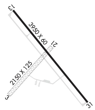
| Lat: N 4236.2 Long: W 09715.2 Elev: 1388 Var: -06 Longest Runway: 3950 | ||
| CTAF: 122.9 | ||
| ||||||||||||||||||||||||||||||||
| ||||||||||||||||||||||||||||||||
| Rwy | Rwy | |||||||
| 2150x125 | 2150' | 2150x125 | 2150' | |||||
| 3950x60 | 3950' | 3950x60 | 3550' | |||||
| Runway ID | Single Wheel | Double Wheel | Double Tandem Wheel | Dual Double Wheel |
| 03/21 | N/A | N/A | N/A | N/A |
| 13/31 | N/A | N/A | N/A | N/A |
| These numbers are Advisory and are not limits. The Airport Manager should have more accurate Weight Limits | ||||
 Airport Diagram might not be current. | |
| Facility Name: | HARTINGTON MUNI/BUD BECKER FLD |
| City Name: | HARTINGTON |
| County: | CEDAR |
| State abbrev: | NE |
| State Name: | NEBRASKA |
| Ownership: | PUBLICLY OWNED |
| Use: | OPEN TO THE PUBLIC |
| Owner's Name: | HARTINGTON AIRPORT AUTHORITY; AIRPORT AUTHORITY CHAIRMAN IS KARMA SCHULTE |
| Address: | P.O. BOX 14, 302 S. CEDAR AVENUE |
| HARTINGTON, NE 68739-0014 | |
| Owner's Phone: | 402-841-0610 |
| Manager's Name: | JOHN BECKER |
| Address: | 56395 881 ROAD |
| HARTINGTON, NE 68739-4021 | |
| Phone: | 402-841-0486; MOBILE PHONE 402-841-0486 (MANAGER) |
| FAA Region: | CENTRAL |
| FAA Field Office: | NONE |

| Date | Sunrise | Sunset |
|---|---|---|
| 06/08/26 Monday | 5:51 | 21:05 |
| 06/09/26 Tuesday | 5:51 | 21:05 |
| 06/10/26 Wednesday | 5:51 | 21:06 |
| 06/11/26 Thursday | 5:51 | 21:07 |
| 06/12/26 Friday | 5:51 | 21:07 |
| 06/13/26 Saturday | 5:51 | 21:08 |
| 06/14/26 Sunday | 5:51 | 21:08 |
| 06/15/26 Monday | 5:51 | 21:08 |
| 06/16/26 Tuesday | 5:51 | 21:09 |
| 06/17/26 Wednesday | 5:51 | 21:09 |
| 06/18/26 Thursday | 5:51 | 21:09 |
| 06/19/26 Friday | 5:51 | 21:10 |
| 06/20/26 Saturday | 5:51 | 21:10 |
| 06/21/26 Sunday | 5:51 | 21:10 |
| Airport Attendance Schedule | CONTINUOUS |
| Airport Status | OPERATIONAL (This Status can change at any time - please check NOTAMS) |
| Airport Lighting Schedule | ACTVT PAPI RWY 13 & 31; MIRL RWY 13/31 - CTAF. |
| Airport Storage Available | Tie Downs, Hanger |
| Extra Services Available | Crop Dusting, Flight Instruction |
| Wind Indicator | YES - (lighted) |
| Control Tower | NO |
| CTAF Frequency | 122.900 |
| Unicom Frequency | |
| Rotating Beacon Color | WG |
| Segmented Circle | NO |
| Landing Fee | NO |
| Airport Inspected | STATE - performed by STATE AERONAUTICAL PERSONNEL |
| Inspection Date | 05/07/2025 |
| Type of Fuel Available | Grade 100LL; -10FOR FUEL CALL 402-254-7316 OR 402-841-0486. |
| Airframe Repair Service | MAJOR |
| Power Plant Repair Service | MAJOR |
| Latitude | N4236.2 |
| Longitude | W09715.2 (ESTIMATED) |
| Arpt Elevation | 1388ft (SURVEYED) |
| Magnetic Variation | 06E |
| 2 miles SE | of HARTINGTON |
| Traffic Pattern Altitude | |
| Sectional Chart | OMAHA |
| Operations (Reported) | Yearly | Avg. Daily |
|---|---|---|
| General Aviation Transient | 0 | 0 |
| General Aviation Local | 0 | 0 |
| Air Taxi | 0 | 0 |
| Commerical | 0 | 0 |
| Commuter | 0 | 0 |
| Military | 0 | 0 |
| Aircraft based on Field | |
|---|---|
| General Aviation Singles | 0 |
| General Aviation Multi | 0 |
| Jet Aircraft | 0 |
| General Aviation Helicopters | 0 |
| Military Aircraft | 0 |
| Gliders | 0 |
| Ultralights | 0 |
| FSS on field | NO |
| FSS tie-in | COLUMBUS |
| FSS Phone | 1-800-WX-BRIEF |
| Who issues Notams | OLU |
| Notam D service at airport | YES |
| ARTCC Name | MINNEAPOLIS |
| Airport Certification | |
| Aircraft Rescue & Firefighting Index | None |
| Airport of Entry | No |
| Custom Landing Rights | No |
| Joint Civil/Military | No |
| Military Landing rights | No |
| NATIONAL PLAN OF INTEGRATED AIRPORT SYSTEMS (NPIAS) |
| GRANT AGREEMENT HAS EXPIRED; HOWEVER, AGREEMENT REMAINS IN EFFECT FOR THIS FACILITY AS LONG AS IT IS PUBLIC USE. |
| FOR CD CTC MINNEAPOLIS ARTCC AT 651-463-5588. |
| RWY 03/2 1 NOT PLOWED DURING WINTER MONTHS. |
Airport Communications & Frequencies:
| |||||||
| Runway: 03 | Runway: 21 | ||
| Mag heading: | 35° | Mag heading: | 215° |
| Rwy Slope: | -.60% Down | Rwy Slope: | .60% Up |
| Approach: | Approach: | ||
| Pattern: | Left Traffic | Pattern: | Left Traffic |
| Markings: | Markings: | ||
| Marking Condition: | Marking Condition: | ||
| Arresting Dev: | Arresting Dev: | ||
| Lat & Long: | N4236.0 W09715.5 | Lat. & Long.: | N4236.3 W09715.1 |
| Elev: | 1387.2 ft. MSL | Elev: | 1374.2 ft. MSL |
| TCH: | TCH: | ||
| Visual Glide Path: | Visual Glide Path: | ||
| Displaced Threshold: | No | Displaced Threshold: | No |
| Touchdown Zone: | YES | Touchdown Zone: | YES |
| Touchdown Elev.: | 1387.2 feet | Touchdown Elev.: | 1387.2 feet |
| Visual Glide Slope: | Visual Glide Slope: | ||
| RVR Equipment: | RVR Equipment: | ||
| RVV Equipment: | NO | RVV Equipment: | NO |
| Approach Lights: | Approach Lights: | ||
| REIL: | NO | REIL: | NO |
| Centerline Lights: | NO | Centerline Lights: | NO |
| Touchdown lights: | NO | Touchdown lights: | NO |
| Runway Category: | Runway with a Visual Approach | Runway Category: | Runway with a Visual Approach |
| Declared Distances: | Declared Distances: |
| Runway: 13 | Runway: 31 | ||
| Mag heading: | 135° | Mag heading: | 315° |
| Rwy Slope: | .34% Up | Rwy Slope: | -.34% Down |
| Approach: | Approach: | ||
| Pattern: | Left Traffic | Pattern: | Left Traffic |
| Markings: | NONPRECISION INSTRUMENT | Markings: | NONPRECISION INSTRUMENT |
| Marking Condition: | GOOD | Marking Condition: | GOOD |
| Arresting Dev: | Arresting Dev: | ||
| Lat & Long: | N4236.5 W09715.4 | Lat. & Long.: | N4236.0 W09714.9 |
| Elev: | 1367.1 ft. MSL | Elev: | 1380.6 ft. MSL |
| TCH: | 46 ft. AGL | TCH: | 40 ft. AGL |
| Visual Glide Path: | 3.50 degrees | Visual Glide Path: | 3.25 degrees |
| Displaced Threshold: | No | Displaced Threshold: | 400 feet |
| Touchdown Zone: | YES | Touchdown Zone: | YES |
| Touchdown Elev.: | 1382.6 feet | Touchdown Elev.: | 1382.7 feet |
| Visual Glide Slope: | 2-Light PAPI on LEFT side of Runway | Visual Glide Slope: | 2-Light PAPI on LEFT side of Runway |
| RVR Equipment: | RVR Equipment: | ||
| RVV Equipment: | NO | RVV Equipment: | NO |
| Approach Lights: | Approach Lights: | ||
| REIL: | NO | REIL: | NO |
| Centerline Lights: | NO | Centerline Lights: | NO |
| Touchdown lights: | NO | Touchdown lights: | NO |
| Runway Category: | Runway with a Non-precision Approach | Runway Category: | Runway with a Non-precision Approach |
| Declared Distances: | Declared Distances: | ||
| Obstructions: | TREE | Obstructions: | |
| Marked: | NOT Marked/Lighted | Marked: | |
| Clearance slope: | 18:1 | Clearance slope: | 20:1; RWY 31 APCH RATIO 21:1 TO DSPLCD THR DUE TO ROAD 31 FT ABV 675 FT FM DSPLCD THR, 351 FT L. |
| Obstruction height: | 70 feet AGL | Obstruction height: | |
| Dist. from runway: | 1487 feet; RWY 13 TREE MASS 1330 FT TO 1250 FT FM RWY END. | Dist. from runway: | |
| Centerline offset: | 420 right of centerline; RWY 13 TREE MASS 300 FT TO 470 FT R OF CNTRLN. | Centerline offset: | |
| Comments: | Comments: | RWY 31 CLOSE-IN OBSTN ROAD 223 RIGHT. |
Thanks for using FltPlan.com
all rights reserved © 1999-2026 by Flight Plan LLC