
| BETHEL RGNL BETHEL ME |
| |
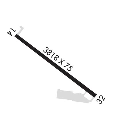
| Lat: N 4425.5 Long: W 07048.6 Elev: 674 Var: +17 Longest Runway: 3818 | ||
| AWOS: 122.9 CTAF: 122.9 | ||
| ||||||||||||||||||||||||||||||||
| ||||||||||||||||||||||||||||||||
| ||||||||||||||||||||||||||||||||
| Rwy | Rwy | |||||||
| 3818x75 | 3818' | 3818x75 | 3818' | |||||
| Runway ID | Single Wheel | Double Wheel | Double Tandem Wheel | Dual Double Wheel |
| 14/32 | N/A | N/A | N/A | N/A |
| These numbers are Advisory and are not limits. The Airport Manager should have more accurate Weight Limits | ||||
 Airport Diagram might not be current. | |
| Facility Name: | BETHEL RGNL |
| City Name: | BETHEL |
| County: | OXFORD |
| State abbrev: | ME |
| State Name: | MAINE |
| Ownership: | PUBLICLY OWNED |
| Use: | OPEN TO THE PUBLIC |
| Owner's Name: | TOWN OF BETHEL |
| Address: | PO BOX 1660 |
| BETHEL, ME 04217 | |
| Owner's Phone: | 207-824-2669 |
| Manager's Name: | RANDY AUTREY; TOWN MGR.. ADDITIONAL CONTACT: RANDY AUTREY - DEPUTY AIRPORT MGR. (207-824-2669) |
| Address: | TOWN OF BETHEL, PO BOX 1660 |
| BETHEL, ME 04217 | |
| Phone: | 207-381-0202; EMERG (POLICE) 1-800-733-1421. |
| FAA Region: | NEW ENGLAND |
| FAA Field Office: | NONE |
| Date | Sunrise | Sunset |
|---|---|---|
| 06/08/26 Monday | 4:59 | 20:26 |
| 06/09/26 Tuesday | 4:59 | 20:26 |
| 06/10/26 Wednesday | 4:59 | 20:27 |
| 06/11/26 Thursday | 4:58 | 20:27 |
| 06/12/26 Friday | 4:58 | 20:28 |
| 06/13/26 Saturday | 4:58 | 20:28 |
| 06/14/26 Sunday | 4:58 | 20:29 |
| 06/15/26 Monday | 4:58 | 20:29 |
| 06/16/26 Tuesday | 4:58 | 20:30 |
| 06/17/26 Wednesday | 4:58 | 20:30 |
| 06/18/26 Thursday | 4:58 | 20:30 |
| 06/19/26 Friday | 4:58 | 20:31 |
| 06/20/26 Saturday | 4:58 | 20:31 |
| 06/21/26 Sunday | 4:59 | 20:31 |
| Airport Attendance Schedule | UNATTENDED |
| Airport Status | OPERATIONAL (This Status can change at any time - please check NOTAMS) |
| Airport Lighting Schedule | ACTVT REIL RWY 32; MIRL RWY 14/32 - CTAF. |
| Airport Storage Available | Tie Downs |
| Extra Services Available | NONE |
| Wind Indicator | YES - (lighted) |
| Control Tower | NO |
| CTAF Frequency | 122.900 |
| Unicom Frequency | |
| Rotating Beacon Color | WG |
| Segmented Circle | YES |
| Landing Fee | NO |
| Airport Inspected | STATE - performed by PRIVATE CONTRACT PERSONNEL |
| Inspection Date | 08/08/2025 |
| Type of Fuel Available | Grade 100LL; -10SELF-SERVE AVBL 24 HRS WITH CREDIT CARD. |
| Airframe Repair Service | NONE |
| Power Plant Repair Service | NONE |
| Latitude | N4425.5 |
| Longitude | W07048.6 (ESTIMATED) |
| Arpt Elevation | 674ft (SURVEYED) |
| Magnetic Variation | 17W |
| 2 miles NW | of BETHEL |
| Traffic Pattern Altitude | |
| Sectional Chart | MONTREAL |
| Operations (Reported) | Yearly | Avg. Daily |
|---|---|---|
| General Aviation Transient | 0 | 0 |
| General Aviation Local | 0 | 0 |
| Air Taxi | 0 | 0 |
| Commerical | 0 | 0 |
| Commuter | 0 | 0 |
| Military | 0 | 0 |
| Aircraft based on Field | |
|---|---|
| General Aviation Singles | 0 |
| General Aviation Multi | 0 |
| Jet Aircraft | 0 |
| General Aviation Helicopters | 0 |
| Military Aircraft | 0 |
| Gliders | 0 |
| Ultralights | 0 |
| FSS on field | NO |
| FSS tie-in | BANGOR |
| FSS Phone | 1-800-WX-BRIEF |
| Who issues Notams | BGR |
| Notam D service at airport | YES |
| ARTCC Name | BOSTON |
| Airport Certification | |
| Aircraft Rescue & Firefighting Index | None |
| Airport of Entry | No |
| Custom Landing Rights | No |
| Joint Civil/Military | No |
| Military Landing rights | No |
| NATIONAL PLAN OF INTEGRATED AIRPORT SYSTEMS (NPIAS) |
| GRANT AGREEMENTS UNDER FAAP/ADAP/AIP |
| ASSURANCES PURSUANT TO TITLE VI, CIVIL RIGHTS ACT OF 1964 |
| TURKEYS & GEESE ON OR INVOF ARPT. |
| FOR CD CTC PORTLAND APCH AT 207-874-7320, WHEN APCH CLSD CTC BOSTON ARTCC AT 603-879-6859. |
| COLD TEMPERATURE AIRPORT. ALTITUDE CORRECTION REQUIRED AT OR BELOW -22C. |
| UNLGTD MTUS TRRN. |
| FOR RWY CONDS OR OTHER INFO, CTC ARPT INFO LINE 207-512-5552. |
| PWRD PRCHT ACTVTY OCNLY IN TRML AREA. |
| FEES FOR PRKG & TIE-DOWNS. ELEC HOOK-UP AVBL. |
| ARPT SFC CONDS UNMON BTN 0200-1300Z DLY. |
| UAS WI 3 NM RDS OF ARPT SFC-400 FT AGL DLY, SR-SS. |
Airport Communications & Frequencies:
| |||||||||||||||
| Runway: 14 | Runway: 32 | ||
| Mag heading: | N/A | Mag heading: | N/A |
| Rwy Slope: | -.47% Down | Rwy Slope: | .47% Up |
| Approach: | Approach: | ||
| Pattern: | Left Traffic | Pattern: | Left Traffic |
| Markings: | BASIC | Markings: | NONPRECISION INSTRUMENT |
| Marking Condition: | FAIR | Marking Condition: | FAIR |
| Arresting Dev: | Arresting Dev: | ||
| Lat & Long: | N4425.7 W07048.9 | Lat. & Long.: | N4425.3 W07048.2 |
| Elev: | 674.0 ft. MSL | Elev: | 656.2 ft. MSL |
| TCH: | TCH: | ||
| Visual Glide Path: | Visual Glide Path: | ||
| Displaced Threshold: | No | Displaced Threshold: | No |
| Touchdown Zone: | YES | Touchdown Zone: | YES |
| Touchdown Elev.: | 674.0 feet | Touchdown Elev.: | 666.7 feet |
| Visual Glide Slope: | Visual Glide Slope: | ||
| RVR Equipment: | RVR Equipment: | ||
| RVV Equipment: | NO | RVV Equipment: | NO |
| Approach Lights: | Approach Lights: | ||
| REIL: | NO | REIL: | YES |
| Centerline Lights: | NO | Centerline Lights: | NO |
| Touchdown lights: | NO | Touchdown lights: | NO |
| Runway Category: | Runway with a Visual Approach | Runway Category: | Runway with a Non-precision Approach |
| Declared Distances: | Declared Distances: | ||
| Obstructions: | TREE | Obstructions: | |
| Marked: | NOT Marked/Lighted | Marked: | |
| Clearance slope: | 5:1 | Clearance slope: | 20:1 |
| Obstruction height: | 18 feet AGL | Obstruction height: | |
| Dist. from runway: | 296 feet | Dist. from runway: | |
| Centerline offset: | 199 right of centerline | Centerline offset: | |
| Comments: | Comments: |
Thanks for using FltPlan.com
all rights reserved © 1999-2026 by Flight Plan LLC
