
| ELIZABETHTON MUNI ELIZABETHTON TN |
| |
| Lat: N 3622.3 Long: W 08210.4 Elev: 1593 Var: +06 Longest Runway: 5001 | ||
| AWOS: 135.67 CTAF: 123.0 | ||
| ||||||||||||||||||||||||||||||||||||||||||||
| ||||||||||||||||||||||||||||||||||||||||||||
| ||||||||||||||||||||||||||||||||||||||||||||
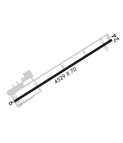
| Rwy | Rwy | |||||||
| 5001x70 | 4904' | 5001x70 | 4099' | |||||
| Runway ID | Single Wheel | Double Wheel | Double Tandem Wheel | Dual Double Wheel |
| 06/24 | 25,000 | N/A | N/A | N/A |
| These numbers are Advisory and are not limits. The Airport Manager should have more accurate Weight Limits | ||||
 Airport Diagram might not be current. | |
| Facility Name: | ELIZABETHTON MUNI |
| City Name: | ELIZABETHTON |
| County: | CARTER |
| State abbrev: | TN |
| State Name: | TENNESSEE |
| Ownership: | PUBLICLY OWNED |
| Use: | OPEN TO THE PUBLIC |
| Owner's Name: | CITY OF ELIZABETHTON |
| Address: | 136 SOUTH SYCAMORE STREET |
| ELIZABETHTON, TN 37643 | |
| Owner's Phone: | (423) 547-6200 |
| Manager's Name: | DAN COGAN |
| Address: | 415 HIGHWAY 91 |
| ELIZABETHTON, TN 37643 | |
| Phone: | 423-543-2801 |
| FAA Region: | SOUTHERN |
| FAA Field Office: | MEM |

| Date | Sunrise | Sunset |
|---|---|---|
| 09/24/21 Friday | 7:18 | 19:23 |
| 09/25/21 Saturday | 7:19 | 19:21 |
| 09/26/21 Sunday | 7:20 | 19:20 |
| 09/27/21 Monday | 7:20 | 19:18 |
| 09/28/21 Tuesday | 7:21 | 19:17 |
| 09/29/21 Wednesday | 7:22 | 19:15 |
| 09/30/21 Thursday | 7:23 | 19:14 |
| 10/01/21 Friday | 7:24 | 19:13 |
| 10/02/21 Saturday | 7:24 | 19:11 |
| 10/03/21 Sunday | 7:25 | 19:10 |
| 10/04/21 Monday | 7:26 | 19:08 |
| 10/05/21 Tuesday | 7:27 | 19:07 |
| 10/06/21 Wednesday | 7:28 | 19:05 |
| 10/07/21 Thursday | 7:29 | 19:04 |
| Airport Attendance Schedule | APR-OCT 7 Days A Week 0730-1930, NOV-MAR 7 Days A Week 0800-1700 |
| Airport Status | OPERATIONAL (This Status can change at any time - please check NOTAMS) |
| Airport Lighting Schedule | ACTVT REIL RWY 06; LIRL RWY 6/24 - CTAF. |
| Airport Storage Available | Tie Downs, Hanger |
| Extra Services Available | Flight Instruction, Aircraft Rental |
| Wind Indicator | YES - (unlit) |
| Control Tower | NO |
| CTAF Frequency | 123.000 |
| Unicom Frequency | 123.000 |
| Rotating Beacon Color | |
| Segmented Circle | YES |
| Landing Fee | NO |
| Airport Inspected | STATE - performed by STATE AERONAUTICAL PERSONNEL |
| Inspection Date | 06/12/2020 |
| Type of Fuel Available | Grade 100LL, JET A (freeze point -40C) |
| Airframe Repair Service | NONE |
| Power Plant Repair Service | NONE |
| Latitude | N3622.3 |
| Longitude | W08210.4 (ESTIMATED) |
| Arpt Elevation | 1592ft (ESTIMATED) |
| Magnetic Variation | 06W |
| 3 miles NE | of ELIZABETHTON |
| Traffic Pattern Altitude | |
| Sectional Chart | CINCINNATI |
| Operations (Reported) | Yearly | Avg. Daily |
|---|---|---|
| General Aviation Transient | 5500 | 15 |
| General Aviation Local | 25000 | 68 |
| Air Taxi | 0 | 0 |
| Commerical | 0 | 0 |
| Commuter | 0 | 0 |
| Military | 0 | 0 |
| Aircraft based on Field | |
|---|---|
| General Aviation Singles | 36 |
| General Aviation Multi | 4 |
| Jet Aircraft | 2 |
| General Aviation Helicopters | 1 |
| Military Aircraft | 0 |
| Gliders | 1 |
| Ultralights | 0 |
| FSS on field | NO |
| FSS tie-in | NASHVILLE |
| FSS Phone | 1-800-WX-BRIEF |
| Who issues Notams | BNA |
| Notam D service at airport | YES |
| ARTCC Name | ATLANTA |
| Airport Certification | |
| Aircraft Rescue & Firefighting Index | None |
| Airport of Entry | No |
| Custom Landing Rights | No |
| Joint Civil/Military | No |
| Military Landing rights | YES |
| NATIONAL PLAN OF INTEGRATED AIRPORT SYSTEMS (NPIAS) |
| GRANT AGREEMENTS UNDER FAAP/ADAP/AIP |
| ASSURANCES PURSUANT TO TITLE VI, CIVIL RIGHTS ACT OF 1964 |
| THIS AIRPORT HAS BEEN SURVEYED BY THE NATIONAL GEODETIC SURVEY. |
| HIGH PERF ACFT DEPARTING RWY 24 MNTN RWY HDG UNTIL RCHG 2600 FT MSL. |
| COLD TEMPERATURE AIRPORT. ALTITUDE CORRECTION REQUIRED AT OR BELOW -14C. |
| FOR CD CTC ATLANTA ARTCC AT 770-210-7692. |
| ALL ARR PPR RQR - AMGR. |
| RWY 06/2 4 NSTD |
Airport Communications & Frequencies:
| |||||||||||||||||||||
| Runway: 06 | Runway: 24 | ||
| Mag heading: | 64° | Mag heading: | 244° |
| Rwy Slope: | .73% Up | Rwy Slope: | -.73% Down |
| Approach: | Approach: | ||
| Pattern: | Right Traffic | Pattern: | Left Traffic |
| Markings: | NONPRECISION INSTRUMENT | Markings: | NONPRECISION INSTRUMENT |
| Marking Condition: | GOOD | Marking Condition: | GOOD |
| Arresting Dev: | Arresting Dev: | ||
| Lat & Long: | N3622.1 W08210.8 | Lat. & Long.: | N3622.5 W08209.9 |
| Elev: | 1555.8 ft. MSL | Elev: | 1592.5 ft. MSL |
| TCH: | 36 ft. AGL | TCH: | |
| Visual Glide Path: | 3.75 degrees | Visual Glide Path: | |
| Displaced Threshold: | 97 feet | Displaced Threshold: | 902 feet |
| Touchdown Zone: | YES | Touchdown Zone: | YES |
| Touchdown Elev.: | 1555.8 feet | Touchdown Elev.: | 1592.5 feet |
| Visual Glide Slope: | 2-BOX SIMPLIFIED ABBREVIATED VISUAL APPROACH SLOPE INDICATOR ON LEFT SIDE OF RUNWAY | Visual Glide Slope: | |
| RVR Equipment: | RVR Equipment: | ||
| RVV Equipment: | NO | RVV Equipment: | NO |
| Approach Lights: | Approach Lights: | ||
| REIL: | YES | REIL: | NO |
| Centerline Lights: | NO | Centerline Lights: | NO |
| Touchdown lights: | NO | Touchdown lights: | NO |
| Runway Category: | Runway with a Non-precision Approach | Runway Category: | Runway with a Visual Approach |
| Declared Distances: | TORA:5001' TODA:5001' ASDA:5001' LDA:4904' | Declared Distances: | TORA:5001' TODA:5001' ASDA:5001' LDA:4099' |
| Obstructions: | TREES | Obstructions: | TREES |
| Marked: | NOT Marked/Lighted | Marked: | NOT Marked/Lighted |
| Clearance slope: | 13:1; APCH SLOPE 27:1 TO DSPLCD THR. | Clearance slope: | 12:1 |
| Obstruction height: | 32 feet AGL | Obstruction height: | 100 feet AGL |
| Dist. from runway: | 635 feet | Dist. from runway: | 1426 feet |
| Centerline offset: | 158 right of centerline | Centerline offset: | 15B |
| Comments: | Comments: |
Thanks for using FltPlan.com
all rights reserved © 1999-2021 by Flight Plan LLC