
| HARVARD STATE HARVARD NE |
| |
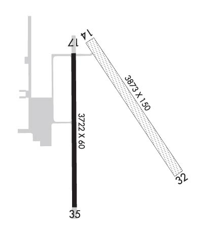
| Lat: N 4039.1 Long: W 09804.8 Elev: 1815 Var: -05 Longest Runway: 3873 | ||
| CTAF: 122.9 | ||
| ||||||
|
| Rwy | Rwy | |||||||
| 3873x150 | 3873' | 3873x150 | 3873' | |||||
| 3722x60 | 3722' | 3722x60 | 3722' | |||||
| Runway ID | Single Wheel | Double Wheel | Double Tandem Wheel | Dual Double Wheel |
| 14/32 | N/A | N/A | N/A | N/A |
| 17/35 | N/A | N/A | N/A | N/A |
| These numbers are Advisory and are not limits. The Airport Manager should have more accurate Weight Limits | ||||
 Airport Diagram might not be current. | |
| Facility Name: | HARVARD STATE |
| City Name: | HARVARD |
| County: | CLAY |
| State abbrev: | NE |
| State Name: | NEBRASKA |
| Ownership: | PUBLICLY OWNED |
| Use: | OPEN TO THE PUBLIC |
| Owner's Name: | NEBRASKA DEPARTMENT OF AERONAUTICS |
| Address: | 3431 AVIATION ROAD, SUITE 150 |
| LINCOLN, NE 68501-2088 | |
| Owner's Phone: | 402-471-2371 |
| Manager's Name: | TIM KRIENERT |
| Address: | 13 AIRBASE ROAD, FAIRMONT STATE AIRFIELD |
| FAIRMONT, NE 68354-4057 | |
| Phone: | (402) 268-4521 |
| FAA Region: | CENTRAL |
| FAA Field Office: | NONE |
| Date | Sunrise | Sunset |
|---|---|---|
| 09/24/21 Friday | 7:22 | 19:26 |
| 09/25/21 Saturday | 7:23 | 19:25 |
| 09/26/21 Sunday | 7:24 | 19:23 |
| 09/27/21 Monday | 7:25 | 19:21 |
| 09/28/21 Tuesday | 7:26 | 19:20 |
| 09/29/21 Wednesday | 7:27 | 19:18 |
| 09/30/21 Thursday | 7:28 | 19:16 |
| 10/01/21 Friday | 7:29 | 19:15 |
| 10/02/21 Saturday | 7:30 | 19:13 |
| 10/03/21 Sunday | 7:31 | 19:11 |
| 10/04/21 Monday | 7:32 | 19:10 |
| 10/05/21 Tuesday | 7:33 | 19:08 |
| 10/06/21 Wednesday | 7:34 | 19:07 |
| 10/07/21 Thursday | 7:35 | 19:05 |
| Airport Attendance Schedule | UNATTENDED; CALL AIRPORT MANAGER 402-268-4521 OR 402-772-3291 CELL 402-266-1890 |
| Airport Status | OPERATIONAL (This Status can change at any time - please check NOTAMS) |
| Airport Lighting Schedule | ACTVT MIRL RY 17/35 - CTAF. |
| Airport Storage Available | Tie Downs, Hanger |
| Extra Services Available | Crop Dusting |
| Wind Indicator | YES - (lighted) |
| Control Tower | NO |
| CTAF Frequency | 122.900 |
| Unicom Frequency | |
| Rotating Beacon Color | CLEAR-GREEN (Light Land Airport) |
| Segmented Circle | YES |
| Landing Fee | NO |
| Airport Inspected | STATE - performed by STATE AERONAUTICAL PERSONNEL |
| Inspection Date | 04/15/2019 |
| Type of Fuel Available | Grade 100LL; -10CALL AMGR FOR SVC. |
| Airframe Repair Service | NONE |
| Power Plant Repair Service | NONE |
| Latitude | N4039.1 |
| Longitude | W09804.8 (ESTIMATED) |
| Arpt Elevation | 1814ft (SURVEYED) |
| Magnetic Variation | 05E |
| 2 miles NE | of HARVARD |
| Traffic Pattern Altitude | |
| Sectional Chart | OMAHA |
| Operations (Reported) | Yearly | Avg. Daily |
|---|---|---|
| General Aviation Transient | 300 | 1 |
| General Aviation Local | 4600 | 13 |
| Air Taxi | 0 | 0 |
| Commerical | 0 | 0 |
| Commuter | 0 | 0 |
| Military | 100 | 0 |
| Aircraft based on Field | |
|---|---|
| General Aviation Singles | 11 |
| General Aviation Multi | 0 |
| Jet Aircraft | 0 |
| General Aviation Helicopters | 0 |
| Military Aircraft | 0 |
| Gliders | 0 |
| Ultralights | 0 |
| FSS on field | NO |
| FSS tie-in | COLUMBUS |
| FSS Phone | 1-800-WX-BRIEF |
| Who issues Notams | OLU |
| Notam D service at airport | YES |
| ARTCC Name | MINNEAPOLIS |
| Airport Certification | |
| Aircraft Rescue & Firefighting Index | None |
| Airport of Entry | No |
| Custom Landing Rights | No |
| Joint Civil/Military | No |
| Military Landing rights | YES |
| NATIONAL PLAN OF INTEGRATED AIRPORT SYSTEMS (NPIAS) |
| SURPLUS PROPERTY AGREEMENT UNDER PUBLIC LAW 289 |
| SURPLUS PROPERTY AGREEMENT UNDER REGULATION 16-WAA |
| GRANT AGREEMENT HAS EXPIRED; HOWEVER, AGREEMENT REMAINS IN EFFECT FOR THIS FACILITY AS LONG AS IT IS PUBLIC USE. |
| FOR CD CTC MINNEAPOLIS ARTCC AT 651-463-5588. |
Airport Communications & Frequencies:
| |||||||
| Runway: 14 | Runway: 32 | ||
| Mag heading: | 142° | Mag heading: | 322° |
| Rwy Slope: | -.04% Down | Rwy Slope: | .04% Up |
| Approach: | Approach: | ||
| Pattern: | Left Traffic | Pattern: | Left Traffic |
| Markings: | Markings: | ||
| Marking Condition: | Marking Condition: | ||
| Arresting Dev: | Arresting Dev: | ||
| Lat & Long: | N4039.4 W09804.9 | Lat. & Long.: | N4038.9 W09804.4 |
| Elev: | 1810.1 ft. MSL | Elev: | 1808.4 ft. MSL |
| TCH: | TCH: | ||
| Visual Glide Path: | Visual Glide Path: | ||
| Displaced Threshold: | No | Displaced Threshold: | No |
| Touchdown Zone: | YES | Touchdown Zone: | YES |
| Touchdown Elev.: | 1810.3 feet | Touchdown Elev.: | 1809.4 feet |
| Visual Glide Slope: | Visual Glide Slope: | ||
| RVR Equipment: | RVR Equipment: | ||
| RVV Equipment: | NO | RVV Equipment: | NO |
| Approach Lights: | Approach Lights: | ||
| REIL: | NO | REIL: | NO |
| Centerline Lights: | NO | Centerline Lights: | NO |
| Touchdown lights: | NO | Touchdown lights: | NO |
| Runway Category: | Runway with a Visual Approach | Runway Category: | Runway with a Visual Approach |
| Declared Distances: | Declared Distances: |
| Runway: 17 | Runway: 35 | ||
| Mag heading: | 175° | Mag heading: | 355° |
| Rwy Slope: | -.21% Down | Rwy Slope: | .21% Up |
| Approach: | Approach: | ||
| Pattern: | Left Traffic | Pattern: | Left Traffic |
| Markings: | NONPRECISION INSTRUMENT | Markings: | NONPRECISION INSTRUMENT |
| Marking Condition: | GOOD | Marking Condition: | GOOD |
| Arresting Dev: | Arresting Dev: | ||
| Lat & Long: | N4039.3 W09805.0 | Lat. & Long.: | N4038.7 W09804.9 |
| Elev: | 1814.1 ft. MSL | Elev: | 1806.2 ft. MSL |
| TCH: | TCH: | ||
| Visual Glide Path: | Visual Glide Path: | ||
| Displaced Threshold: | No | Displaced Threshold: | No |
| Touchdown Zone: | YES | Touchdown Zone: | YES |
| Touchdown Elev.: | 1814.5 feet | Touchdown Elev.: | 1814.0 feet |
| Visual Glide Slope: | Visual Glide Slope: | ||
| RVR Equipment: | RVR Equipment: | ||
| RVV Equipment: | NO | RVV Equipment: | NO |
| Approach Lights: | Approach Lights: | ||
| REIL: | NO | REIL: | NO |
| Centerline Lights: | NO | Centerline Lights: | NO |
| Touchdown lights: | NO | Touchdown lights: | NO |
| Runway Category: | Runway with a Non-precision Approach | Runway Category: | Runway with a Non-precision Approach |
| Declared Distances: | Declared Distances: |
Thanks for using FltPlan.com
all rights reserved © 1999-2021 by Flight Plan LLC
