
| RIVERVIEW JENISON MI |
| |
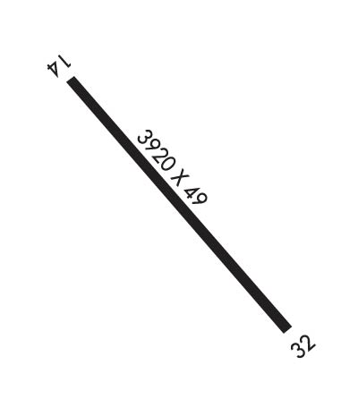
| Lat: N 4256.2 Long: W 08548.3 Elev: 603 Var: +03 Longest Runway: 3920 | ||
| CTAF: 122.9 | ||
| ||||||
|
| Rwy | Rwy | |||||||
| 3920x49 | 3920' | 3920x49 | 2724' | |||||
| Runway ID | Single Wheel | Double Wheel | Double Tandem Wheel | Dual Double Wheel |
| 14/32 | N/A | N/A | N/A | N/A |
| These numbers are Advisory and are not limits. The Airport Manager should have more accurate Weight Limits | ||||
| FltPlan does not have IFR approach charts available for K08C. |
 Airport Diagram might not be current. | |
| Facility Name: | RIVERVIEW |
| City Name: | JENISON |
| County: | OTTAWA |
| State abbrev: | MI |
| State Name: | MICHIGAN |
| Ownership: | PRIVATELY OWNED |
| Use: | OPEN TO THE PUBLIC |
| Owner's Name: | RIVERTOWN AIRPORT LCC |
| Address: | 1129 TAYLOR; ARPT PHYSICAL ADDR 805 TAYLOR, JENISON, MI 49428 |
| JENISON, MI 49428 | |
| Owner's Phone: | 616-457-5040 |
| Manager's Name: | NATHAN D. BOYNTON |
| Address: | 1129 TAYLOR |
| JENISON, MI 49428 | |
| Phone: | 616-457-5040 |
| FAA Region: | GREAT LAKES |
| FAA Field Office: | DET |
| Date | Sunrise | Sunset |
|---|---|---|
| 09/24/21 Friday | 7:32 | 19:37 |
| 09/25/21 Saturday | 7:34 | 19:36 |
| 09/26/21 Sunday | 7:35 | 19:34 |
| 09/27/21 Monday | 7:36 | 19:32 |
| 09/28/21 Tuesday | 7:37 | 19:30 |
| 09/29/21 Wednesday | 7:38 | 19:28 |
| 09/30/21 Thursday | 7:39 | 19:27 |
| 10/01/21 Friday | 7:40 | 19:25 |
| 10/02/21 Saturday | 7:41 | 19:23 |
| 10/03/21 Sunday | 7:42 | 19:21 |
| 10/04/21 Monday | 7:44 | 19:20 |
| 10/05/21 Tuesday | 7:45 | 19:18 |
| 10/06/21 Wednesday | 7:46 | 19:16 |
| 10/07/21 Thursday | 7:47 | 19:14 |
| Airport Attendance Schedule | MON-FRI 0800-1700, SAT-SUN IREG |
| Airport Status | OPERATIONAL (This Status can change at any time - please check NOTAMS) |
| Airport Lighting Schedule | ACTVT MIRL RY 14/32 - CTAF.; OPERATES DUSK-2400. |
| Airport Storage Available | Tie Downs, Hanger |
| Extra Services Available | NONE |
| Wind Indicator | YES - (lighted) |
| Control Tower | NO |
| CTAF Frequency | 122.900 |
| Unicom Frequency | |
| Rotating Beacon Color | CLEAR-GREEN (Light Land Airport) |
| Segmented Circle | YES |
| Landing Fee | NO |
| Airport Inspected | STATE - performed by STATE AERONAUTICAL PERSONNEL |
| Inspection Date | 06/25/2018 |
| Type of Fuel Available | Grade 100LL; -10FUEL 24 HR SELF SERVE. |
| Airframe Repair Service | MAJOR |
| Power Plant Repair Service | MAJOR |
| Latitude | N4256.2 |
| Longitude | W08548.3 (ESTIMATED) |
| Arpt Elevation | 603ft (ESTIMATED) |
| Magnetic Variation | 03W |
| 3 miles NW | of JENISON |
| Traffic Pattern Altitude | |
| Sectional Chart | CHICAGO |
| Operations (Reported) | Yearly | Avg. Daily |
|---|---|---|
| General Aviation Transient | 2500 | 7 |
| General Aviation Local | 2500 | 7 |
| Air Taxi | 0 | 0 |
| Commerical | 0 | 0 |
| Commuter | 0 | 0 |
| Military | 0 | 0 |
| Aircraft based on Field | |
|---|---|
| General Aviation Singles | 33 |
| General Aviation Multi | 5 |
| Jet Aircraft | 0 |
| General Aviation Helicopters | 2 |
| Military Aircraft | 0 |
| Gliders | 0 |
| Ultralights | 0 |
| FSS on field | NO |
| FSS tie-in | LANSING |
| FSS Phone | 1-800-WX-BRIEF |
| Who issues Notams | LAN |
| Notam D service at airport | YES |
| ARTCC Name | CHICAGO |
| Airport Certification | |
| Aircraft Rescue & Firefighting Index | None |
| Airport of Entry | No |
| Custom Landing Rights | No |
| Joint Civil/Military | No |
| Military Landing rights | No |
| DEER & BIRDS ON & INVOF ARPT. |
| ADMIN BLDG ACCESS, DEPRESS V, THEN III-II SIMULTANEOUS, THEN I. |
| FOR CD CTC GREAT LAKES APCH AT 269-459-3344, WHEN APCH CLSD CTC CHICAGO ARTCC AT 630-906-8921. |
| Runway: 14 | Runway: 32 | ||
| Mag heading: | N/A | Mag heading: | N/A |
| Rwy Slope: | .00% | Rwy Slope: | .00% |
| Approach: | Approach: | ||
| Pattern: | Left Traffic | Pattern: | Left Traffic |
| Markings: | BASIC | Markings: | BASIC |
| Marking Condition: | POOR; MKGS FADED BARELY VISIBLE. | Marking Condition: | POOR; MKGS FADED BARELY VISIBLE. |
| Arresting Dev: | Arresting Dev: | ||
| Lat & Long: | N4256.4 W08548.6 | Lat. & Long.: | N4256.0 W08548.1 |
| Elev: | 603.0 ft. MSL | Elev: | 603.0 ft. MSL |
| TCH: | TCH: | ||
| Visual Glide Path: | Visual Glide Path: | ||
| Displaced Threshold: | No | Displaced Threshold: | 1196 feet |
| Touchdown Zone: | NO | Touchdown Zone: | NO |
| Touchdown Elev.: | Touchdown Elev.: | ||
| Visual Glide Slope: | Visual Glide Slope: | ||
| RVR Equipment: | RVR Equipment: | ||
| RVV Equipment: | NO | RVV Equipment: | NO |
| Approach Lights: | Approach Lights: | ||
| REIL: | NO | REIL: | NO |
| Centerline Lights: | NO | Centerline Lights: | NO |
| Touchdown lights: | NO | Touchdown lights: | NO |
| Runway Category: | Runway with a Visual Approach | Runway Category: | Runway with a Visual Approach |
| Declared Distances: | Declared Distances: | ||
| Obstructions: | TREES | Obstructions: | TREES |
| Marked: | NOT Marked/Lighted | Marked: | NOT Marked/Lighted |
| Clearance slope: | 8:1 | Clearance slope: | 2:1; APCH RATIO 20:1 AT DSPLCD THLD BASED ON 75 FT TREES 1900 FT FROM DSPLCD THLD & 145 FT TREES 2900 FT FROM DSPLCD THLD. |
| Obstruction height: | 54 feet AGL | Obstruction height: | 68 feet AGL |
| Dist. from runway: | 642 feet | Dist. from runway: | 400 feet |
| Centerline offset: | 100 right of centerline | Centerline offset: | |
| Comments: | +10 FT BRUSH 30-75 FT DSTC 0-125 L/R. | Comments: | +15 FT RD AND +40 FT TREES 90 FT R/L. |
Thanks for using FltPlan.com
all rights reserved © 1999-2021 by Flight Plan LLC
