
| WETUMPKA MUNI WETUMPKA AL |
| |
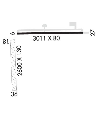
| Lat: N 3231.6 Long: W 08619.9 Elev: 197 Var: +03 Longest Runway: 3013 | ||
| CTAF: 123.05 | ||
| ||||||
|
| Rwy | Rwy | |||||||
| 3013x80 | 3013' | 3013x80 | 3013' | |||||
| 2876x130 | 2876' | 2876x130 | 1893' | |||||
| Runway ID | Single Wheel | Double Wheel | Double Tandem Wheel | Dual Double Wheel |
| 09/27 | 15,000 | N/A | N/A | N/A |
| 18/36 | N/A | N/A | N/A | N/A |
| These numbers are Advisory and are not limits. The Airport Manager should have more accurate Weight Limits | ||||
 Airport Diagram might not be current. | |
| Facility Name: | WETUMPKA MUNI |
| City Name: | WETUMPKA |
| County: | ELMORE |
| State abbrev: | AL |
| State Name: | ALABAMA |
| Ownership: | PUBLICLY OWNED |
| Use: | OPEN TO THE PUBLIC |
| Owner's Name: | CITY OF WETUMPKA |
| Address: | PO BOX 1180 |
| WETUMPKA, AL 36092 | |
| Owner's Phone: | 334-567-5147 |
| Manager's Name: | LYNN WELDON |
| Address: | 1285 HIGHWAY 14 |
| ELMORE, AL 36025 | |
| Phone: | 334-285-5843 |
| FAA Region: | SOUTHERN |
| FAA Field Office: | JAN |
| Date | Sunrise | Sunset |
|---|---|---|
| 09/24/21 Friday | 6:35 | 18:40 |
| 09/25/21 Saturday | 6:35 | 18:38 |
| 09/26/21 Sunday | 6:36 | 18:37 |
| 09/27/21 Monday | 6:37 | 18:36 |
| 09/28/21 Tuesday | 6:37 | 18:34 |
| 09/29/21 Wednesday | 6:38 | 18:33 |
| 09/30/21 Thursday | 6:39 | 18:32 |
| 10/01/21 Friday | 6:39 | 18:30 |
| 10/02/21 Saturday | 6:40 | 18:29 |
| 10/03/21 Sunday | 6:41 | 18:28 |
| 10/04/21 Monday | 6:41 | 18:26 |
| 10/05/21 Tuesday | 6:42 | 18:25 |
| 10/06/21 Wednesday | 6:43 | 18:24 |
| 10/07/21 Thursday | 6:43 | 18:23 |
| Airport Attendance Schedule | UNATTENDED; FOR ARPT ATTENDANT AFT HRS CALL 334-850-2568 |
| Airport Status | OPERATIONAL (This Status can change at any time - please check NOTAMS) |
| Airport Lighting Schedule | DUSK-DAWN. ACTVT MIRL RWY 09/27 - CTAF. |
| Airport Storage Available | Tie Downs |
| Extra Services Available | Avionics, Flight Instruction, Aircraft Rental |
| Wind Indicator | YES - (lighted) |
| Control Tower | NO |
| CTAF Frequency | 123.050 |
| Unicom Frequency | 123.050 |
| Rotating Beacon Color | CLEAR-GREEN (Light Land Airport) |
| Segmented Circle | YES |
| Landing Fee | NO |
| Airport Inspected | STATE - performed by STATE AERONAUTICAL PERSONNEL |
| Inspection Date | 02/26/2021 |
| Type of Fuel Available | Grade 100LL |
| Airframe Repair Service | MAJOR |
| Power Plant Repair Service | MAJOR |
| Latitude | N3231.6 |
| Longitude | W08619.9 (ESTIMATED) |
| Arpt Elevation | 197ft (SURVEYED) |
| Magnetic Variation | 03W |
| 6 miles W | of WETUMPKA |
| Traffic Pattern Altitude | |
| Sectional Chart | ATLANTA |
| Operations (Reported) | Yearly | Avg. Daily |
|---|---|---|
| General Aviation Transient | 32500 | 89 |
| General Aviation Local | 6900 | 19 |
| Air Taxi | 0 | 0 |
| Commerical | 0 | 0 |
| Commuter | 0 | 0 |
| Military | 0 | 0 |
| Aircraft based on Field | |
|---|---|
| General Aviation Singles | 60 |
| General Aviation Multi | 1 |
| Jet Aircraft | 0 |
| General Aviation Helicopters | 0 |
| Military Aircraft | 0 |
| Gliders | 0 |
| Ultralights | 0 |
| FSS on field | NO |
| FSS tie-in | ANNISTON |
| FSS Phone | 1-800-WX-BRIEF |
| Who issues Notams | ANB |
| Notam D service at airport | YES |
| ARTCC Name | ATLANTA |
| Airport Certification | |
| Aircraft Rescue & Firefighting Index | None |
| Airport of Entry | No |
| Custom Landing Rights | No |
| Joint Civil/Military | No |
| Military Landing rights | YES |
| NATIONAL PLAN OF INTEGRATED AIRPORT SYSTEMS (NPIAS) |
| GRANT AGREEMENTS UNDER FAAP/ADAP/AIP |
| SURPLUS PROPERTY AGREEMENT UNDER PUBLIC LAW 289 |
| SURPLUS PROPERTY AGREEMENT UNDER REGULATION 16-WAA |
| ASSURANCES PURSUANT TO TITLE VI, CIVIL RIGHTS ACT OF 1964 |
| FOR CD CTC MONTGOMERY APCH AT 334-284-4575. WHEN APCH CLSD FOR CD CTC ATLANTA ARTCC AT 770-210-7692. |
Airport Communications & Frequencies:
| |||||||||||||||||
| Runway: 09 | Runway: 27 | ||
| Mag heading: | 92° | Mag heading: | 272° |
| Rwy Slope: | -.01% Down | Rwy Slope: | .01% Up |
| Approach: | Approach: | ||
| Pattern: | Left Traffic | Pattern: | Left Traffic |
| Markings: | NONPRECISION INSTRUMENT | Markings: | NONPRECISION INSTRUMENT |
| Marking Condition: | GOOD | Marking Condition: | GOOD |
| Arresting Dev: | Arresting Dev: | ||
| Lat & Long: | N3231.8 W08620.0 | Lat. & Long.: | N3231.8 W08619.4 |
| Elev: | 196.7 ft. MSL | Elev: | 196.4 ft. MSL |
| TCH: | TCH: | ||
| Visual Glide Path: | Visual Glide Path: | ||
| Displaced Threshold: | No | Displaced Threshold: | No |
| Touchdown Zone: | YES | Touchdown Zone: | YES |
| Touchdown Elev.: | 197.1 feet | Touchdown Elev.: | 197.1 feet |
| Visual Glide Slope: | Visual Glide Slope: | ||
| RVR Equipment: | RVR Equipment: | ||
| RVV Equipment: | NO | RVV Equipment: | NO |
| Approach Lights: | Approach Lights: | ||
| REIL: | YES | REIL: | YES |
| Centerline Lights: | NO | Centerline Lights: | NO |
| Touchdown lights: | NO | Touchdown lights: | NO |
| Runway Category: | Runway with a Non-precision Approach | Runway Category: | Runway with a Non-precision Approach |
| Declared Distances: | Declared Distances: | ||
| Obstructions: | TREES | Obstructions: | TREES |
| Marked: | NOT Marked/Lighted | Marked: | NOT Marked/Lighted |
| Clearance slope: | 16:1 | Clearance slope: | 16:1 |
| Obstruction height: | 87 feet AGL | Obstruction height: | 64 feet AGL |
| Dist. from runway: | 1606 feet | Dist. from runway: | 1253 feet |
| Centerline offset: | 230 left of centerline | Centerline offset: | 222 feet left of centerline |
| Comments: | Comments: |
| Runway: 18 | Runway: 36 | ||
| Mag heading: | 184° | Mag heading: | 4° |
| Rwy Slope: | -.16% Down | Rwy Slope: | .16% Up |
| Approach: | Approach: | ||
| Pattern: | Left Traffic | Pattern: | Left Traffic |
| Markings: | BASIC | Markings: | BASIC |
| Marking Condition: | GOOD; MKD WITH 36 INCH WHITE CONES. | Marking Condition: | GOOD; MKD WITH 36 INCH WHITE CONES. |
| Arresting Dev: | Arresting Dev: | ||
| Lat & Long: | N3231.7 W08620.0 | Lat. & Long.: | N3231.3 W08620.0 |
| Elev: | 195.7 ft. MSL | Elev: | 191.0 ft. MSL |
| TCH: | TCH: | ||
| Visual Glide Path: | Visual Glide Path: | ||
| Displaced Threshold: | No | Displaced Threshold: | 983 feet |
| Touchdown Zone: | YES | Touchdown Zone: | YES |
| Touchdown Elev.: | 195.7 feet | Touchdown Elev.: | 195.7 feet |
| Visual Glide Slope: | Visual Glide Slope: | ||
| RVR Equipment: | RVR Equipment: | ||
| RVV Equipment: | NO | RVV Equipment: | NO |
| Approach Lights: | Approach Lights: | ||
| REIL: | NO | REIL: | NO |
| Centerline Lights: | NO | Centerline Lights: | NO |
| Touchdown lights: | NO | Touchdown lights: | NO |
| Runway Category: | Runway with a Visual Approach | Runway Category: | Runway with a Visual Approach |
| Declared Distances: | Declared Distances: | ||
| Obstructions: | PLINE | Obstructions: | TREES |
| Marked: | MARKED | Marked: | NOT Marked/Lighted |
| Clearance slope: | 20:1 | Clearance slope: | 3:1; APCH RATIO 16:1 FROM DSPLCD THR. |
| Obstruction height: | 42 feet AGL | Obstruction height: | 80 feet AGL |
| Dist. from runway: | 843 feet | Dist. from runway: | 300 feet |
| Centerline offset: | 833 right of centerline | Centerline offset: | 187 feet right of centerline |
| Comments: | Comments: |
Thanks for using FltPlan.com
all rights reserved © 1999-2021 by Flight Plan LLC
