
| ROLLA MUNI ROLLA ND |
| |
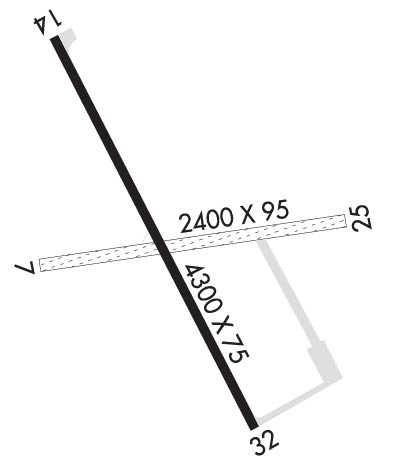
| Lat: N 4853.1 Long: W 09937.3 Elev: 1823 Var: -05 Longest Runway: 4300 | ||
| AWOS: 118.12 CTAF: 122.8 | ||
| ||||||||||||||||||||||||||||||||||||||||||||
| ||||||||||||||||||||||||||||||||||||||||||||
| ||||||||||||||||||||||||||||||||||||||||||||
| Rwy | Rwy | |||||||
| 2200x75 | 2200' | 2200x75 | 2200' | |||||
| 4300x75 | 4300' | 4300x75 | 4300' | |||||
| Runway ID | Single Wheel | Double Wheel | Double Tandem Wheel | Dual Double Wheel |
| 07/25 | N/A | N/A | N/A | N/A |
| 14/32 | 12,500 | N/A | N/A | N/A |
| These numbers are Advisory and are not limits. The Airport Manager should have more accurate Weight Limits | ||||
 Airport Diagram might not be current. | |
| Facility Name: | ROLLA MUNI/LEONARD KRECH FLD |
| City Name: | ROLLA |
| County: | ROLETTE |
| State abbrev: | ND |
| State Name: | NORTH DAKOTA |
| Ownership: | PUBLICLY OWNED |
| Use: | OPEN TO THE PUBLIC |
| Owner's Name: | ROLLA AIRPORT AUTHORITY |
| Address: | 10125 COUNTY RD 23 |
| ROLLA, ND 58367 | |
| Owner's Phone: | 701-550-9884 |
| Manager's Name: | GORDON KRECH |
| Address: | 1104 6TH ST NE |
| ROLLA, ND 58367 | |
| Phone: | 701-550-9884; ADDNL PHONE CELL PHONE 701-550-0134 OR AL KRECH 701-550-9885. |
| FAA Region: | GREAT LAKES |
| FAA Field Office: | DMA |
| Date | Sunrise | Sunset |
|---|---|---|
| 06/12/26 Friday | 5:35 | 21:42 |
| 06/13/26 Saturday | 5:34 | 21:43 |
| 06/14/26 Sunday | 5:34 | 21:43 |
| 06/15/26 Monday | 5:34 | 21:44 |
| 06/16/26 Tuesday | 5:34 | 21:44 |
| 06/17/26 Wednesday | 5:34 | 21:45 |
| 06/18/26 Thursday | 5:34 | 21:45 |
| 06/19/26 Friday | 5:34 | 21:45 |
| 06/20/26 Saturday | 5:34 | 21:46 |
| 06/21/26 Sunday | 5:35 | 21:46 |
| 06/22/26 Monday | 5:35 | 21:46 |
| 06/23/26 Tuesday | 5:35 | 21:46 |
| 06/24/26 Wednesday | 5:35 | 21:46 |
| 06/25/26 Thursday | 5:36 | 21:46 |
| Airport Attendance Schedule | 7 Days A Week ON CALL; FOR ATTENDANT CALL 701-550-9884 OR 701-550-0134. |
| Airport Status | OPERATIONAL (This Status can change at any time - please check NOTAMS) |
| Airport Lighting Schedule | ACTVT MIRL RY 14/32 & PAPI RYS 14 & 32 - CTAF. |
| Airport Storage Available | Tie Downs, Hanger |
| Extra Services Available | Crop Dusting |
| Wind Indicator | YES - (lighted) |
| Control Tower | NO |
| CTAF Frequency | 122.800 |
| Unicom Frequency | 122.800 |
| Rotating Beacon Color | WG |
| Segmented Circle | NO |
| Landing Fee | NO |
| Airport Inspected | STATE - performed by STATE AERONAUTICAL PERSONNEL |
| Inspection Date | 06/18/2025 |
| Type of Fuel Available | Grade 100LL, JET A (freeze point -40C); -1024 HOUR SELF SERVICE CREDIT CARD FUEL AVBL. |
| Airframe Repair Service | NONE |
| Power Plant Repair Service | NONE |
| Latitude | N4853.1 |
| Longitude | W09937.3 (ESTIMATED) |
| Arpt Elevation | 1822ft (SURVEYED) |
| Magnetic Variation | 05E |
| 2 miles N | of ROLLA |
| Traffic Pattern Altitude | |
| Sectional Chart | TWIN CITIES |
| Operations (Reported) | Yearly | Avg. Daily |
|---|---|---|
| General Aviation Transient | 0 | 0 |
| General Aviation Local | 0 | 0 |
| Air Taxi | 0 | 0 |
| Commerical | 0 | 0 |
| Commuter | 0 | 0 |
| Military | 0 | 0 |
| Aircraft based on Field | |
|---|---|
| General Aviation Singles | 0 |
| General Aviation Multi | 0 |
| Jet Aircraft | 0 |
| General Aviation Helicopters | 0 |
| Military Aircraft | 0 |
| Gliders | 0 |
| Ultralights | 0 |
| FSS on field | NO |
| FSS tie-in | GRAND FORKS |
| FSS Phone | 1-800-WX-BRIEF |
| Who issues Notams | GFK |
| Notam D service at airport | YES |
| ARTCC Name | MINNEAPOLIS |
| Airport Certification | |
| Aircraft Rescue & Firefighting Index | None |
| Airport of Entry | No |
| Custom Landing Rights | No |
| Joint Civil/Military | No |
| Military Landing rights | No |
| NATIONAL PLAN OF INTEGRATED AIRPORT SYSTEMS (NPIAS) |
| GRANT AGREEMENT HAS EXPIRED; HOWEVER, AGREEMENT REMAINS IN EFFECT FOR THIS FACILITY AS LONG AS IT IS PUBLIC USE. |
| FOR SNOW REMOVAL & ARPT CONDS CALL AMGR 701-550-9884, 701-550-0134 OR 701-550-9885. |
| RY 07/25 CLSD WINTER MONTHS (OCT-APR) DUE TO LACK OF SNOW REMOVAL. |
| WATERFOWL & BIRDS ON & INVOF AIRPORT. |
| FOR AWOS CALL 701-477-0055. |
| FOR CD IF UNA TO CTC ON FSS FREQ, CTC MINNEAPOLIS ARTCC AT 651-463-5588. |
Airport Communications & Frequencies:
| |||||||||
| Runway: 07 | Runway: 25 | ||
| Mag heading: | 77° | Mag heading: | 257° |
| Rwy Slope: | -.40% Down | Rwy Slope: | .40% Up |
| Approach: | Approach: | ||
| Pattern: | Left Traffic | Pattern: | Left Traffic |
| Markings: | Markings: | ||
| Marking Condition: | Marking Condition: | ||
| Arresting Dev: | Arresting Dev: | ||
| Lat & Long: | N4853.0 W09937.5 | Lat. & Long.: | N4853.1 W09936.9 |
| Elev: | 1820.8 ft. MSL | Elev: | 1811.9 ft. MSL |
| TCH: | TCH: | ||
| Visual Glide Path: | Visual Glide Path: | ||
| Displaced Threshold: | No | Displaced Threshold: | No |
| Touchdown Zone: | YES | Touchdown Zone: | YES |
| Touchdown Elev.: | 1820.8 feet | Touchdown Elev.: | 1820.8 feet |
| Visual Glide Slope: | Visual Glide Slope: | ||
| RVR Equipment: | RVR Equipment: | ||
| RVV Equipment: | NO | RVV Equipment: | NO |
| Approach Lights: | Approach Lights: | ||
| REIL: | NO | REIL: | NO |
| Centerline Lights: | NO | Centerline Lights: | NO |
| Touchdown lights: | NO | Touchdown lights: | NO |
| Runway Category: | Runway with a Visual Approach | Runway Category: | Runway with a Visual Approach |
| Declared Distances: | Declared Distances: |
| Runway: 14 | Runway: 32 | ||
| Mag heading: | 145° | Mag heading: | 325° |
| Rwy Slope: | -.14% Down | Rwy Slope: | .14% Up |
| Approach: | Approach: | ||
| Pattern: | Left Traffic | Pattern: | Left Traffic |
| Markings: | NONPRECISION INSTRUMENT | Markings: | NONPRECISION INSTRUMENT |
| Marking Condition: | FAIR | Marking Condition: | FAIR |
| Arresting Dev: | Arresting Dev: | ||
| Lat & Long: | N4853.4 W09937.6 | Lat. & Long.: | N4852.8 W09937.0 |
| Elev: | 1822.6 ft. MSL | Elev: | 1816.5 ft. MSL |
| TCH: | 27 ft. AGL | TCH: | 27 ft. AGL |
| Visual Glide Path: | 3.00 degrees | Visual Glide Path: | 3.00 degrees |
| Displaced Threshold: | No | Displaced Threshold: | No |
| Touchdown Zone: | YES | Touchdown Zone: | YES |
| Touchdown Elev.: | 1822.6 feet | Touchdown Elev.: | 1818.8 feet |
| Visual Glide Slope: | 2-Light PAPI on LEFT side of Runway | Visual Glide Slope: | 2-Light PAPI on LEFT side of Runway |
| RVR Equipment: | RVR Equipment: | ||
| RVV Equipment: | NO | RVV Equipment: | NO |
| Approach Lights: | Approach Lights: | ||
| REIL: | NO | REIL: | NO |
| Centerline Lights: | NO | Centerline Lights: | NO |
| Touchdown lights: | NO | Touchdown lights: | NO |
| Runway Category: | Runway with a Visual Approach | Runway Category: | Runway with a Non-precision Approach |
| Declared Distances: | Declared Distances: |
Thanks for using FltPlan.com
all rights reserved © 1999-2026 by Flight Plan LLC
