
| NEW TOWN MUNI NEW TOWN ND |
| |
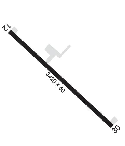
| Lat: N 4758.1 Long: W 10228.7 Elev: 1924 Var: -07 Longest Runway: 3720 | ||
| CTAF: 122.9 | ||
| ||||||||||||||||||||||||||||||||
| ||||||||||||||||||||||||||||||||
| Rwy | Rwy | |||||||
| 3720x60 | 3720' | 3720x60 | 3424' | |||||
| Runway ID | Single Wheel | Double Wheel | Double Tandem Wheel | Dual Double Wheel |
| 12/30 | 12,000 | N/A | N/A | N/A |
| These numbers are Advisory and are not limits. The Airport Manager should have more accurate Weight Limits | ||||
 Airport Diagram might not be current. | |
| Facility Name: | NEW TOWN MUNI |
| City Name: | NEW TOWN |
| County: | MOUNTRAIL |
| State abbrev: | ND |
| State Name: | NORTH DAKOTA |
| Ownership: | PUBLICLY OWNED |
| Use: | OPEN TO THE PUBLIC |
| Owner's Name: | NEW TOWN ARPT AUTH; APT CHAIRMAN GARRETT STUBSTAD |
| Address: | 4474 106TH AVENUE NW |
| NEW TOWN, ND 58763 | |
| Owner's Phone: | 701-421-0401 |
| Manager's Name: | GARRETT STUBSTAD |
| Address: | 4413 87TH DRIVE NW |
| NEW TOWN, ND 58763 | |
| Phone: | 701-421-0401; ADDNL CTC LANGE WHITE AT 701-330-0240. |
| FAA Region: | GREAT LAKES |
| FAA Field Office: | DMA |
| Date | Sunrise | Sunset |
|---|---|---|
| 06/08/26 Monday | 5:51 | 21:47 |
| 06/09/26 Tuesday | 5:51 | 21:48 |
| 06/10/26 Wednesday | 5:51 | 21:48 |
| 06/11/26 Thursday | 5:50 | 21:49 |
| 06/12/26 Friday | 5:50 | 21:49 |
| 06/13/26 Saturday | 5:50 | 21:50 |
| 06/14/26 Sunday | 5:50 | 21:51 |
| 06/15/26 Monday | 5:50 | 21:51 |
| 06/16/26 Tuesday | 5:50 | 21:51 |
| 06/17/26 Wednesday | 5:50 | 21:52 |
| 06/18/26 Thursday | 5:50 | 21:52 |
| 06/19/26 Friday | 5:50 | 21:52 |
| 06/20/26 Saturday | 5:50 | 21:53 |
| 06/21/26 Sunday | 5:50 | 21:53 |
| Airport Attendance Schedule | UNATTENDED |
| Airport Status | OPERATIONAL (This Status can change at any time - please check NOTAMS) |
| Airport Lighting Schedule | ACTVT MIRL RWY 12/30 - CTAF; RWY 12/30 PAPIS & WINDCONE ON CONSLY. |
| Airport Storage Available | Tie Downs |
| Extra Services Available | NONE |
| Wind Indicator | YES - (lighted) |
| Control Tower | NO |
| CTAF Frequency | 122.900 |
| Unicom Frequency | |
| Rotating Beacon Color | |
| Segmented Circle | NO |
| Landing Fee | NO |
| Airport Inspected | STATE - performed by STATE AERONAUTICAL PERSONNEL |
| Inspection Date | 09/01/2023 |
| Type of Fuel Available | None |
| Airframe Repair Service | None |
| Power Plant Repair Service | None |
| Latitude | N4758.1 |
| Longitude | W10228.7 (ESTIMATED) |
| Arpt Elevation | 1924ft (ESTIMATED) |
| Magnetic Variation | 07E |
| 1 miles SE | of NEW TOWN |
| Traffic Pattern Altitude | |
| Sectional Chart | BILLINGS |
| Operations (Reported) | Yearly | Avg. Daily |
|---|---|---|
| General Aviation Transient | 0 | 0 |
| General Aviation Local | 0 | 0 |
| Air Taxi | 0 | 0 |
| Commerical | 0 | 0 |
| Commuter | 0 | 0 |
| Military | 0 | 0 |
| Aircraft based on Field | |
|---|---|
| General Aviation Singles | 0 |
| General Aviation Multi | 0 |
| Jet Aircraft | 0 |
| General Aviation Helicopters | 0 |
| Military Aircraft | 0 |
| Gliders | 0 |
| Ultralights | 0 |
| FSS on field | NO |
| FSS tie-in | GRAND FORKS |
| FSS Phone | 1-800-WX-BRIEF |
| Who issues Notams | GFK |
| Notam D service at airport | YES |
| ARTCC Name | MINNEAPOLIS |
| Airport Certification | |
| Aircraft Rescue & Firefighting Index | None |
| Airport of Entry | No |
| Custom Landing Rights | No |
| Joint Civil/Military | No |
| Military Landing rights | YES |
| ASSURANCES PURSUANT TO TITLE VI, CIVIL RIGHTS ACT OF 1964 |
| GRANT AGREEMENT HAS EXPIRED; HOWEVER, AGREEMENT REMAINS IN EFFECT FOR THIS FACILITY AS LONG AS IT IS PUBLIC USE. |
| RWY 12/30 SN REMOVAL IREG; FOR RWY COND CALL 701-898-4139 OR 701-898-4918. |
| BIRDS INVOF ARPT NEAR LAGOON. |
| DEER ON OR INVOF ARPT. |
| FOR CD CTC MINNEAPOLIS ARTCC AT 651-463-5588. |
Airport Communications & Frequencies:
| |||||||
| Runway: 12 | Runway: 30 | ||
| Mag heading: | 125° | Mag heading: | 305° |
| Rwy Slope: | .15% Up | Rwy Slope: | -.15% Down |
| Approach: | Approach: | ||
| Pattern: | Left Traffic | Pattern: | Left Traffic |
| Markings: | NONPRECISION INSTRUMENT | Markings: | NONPRECISION INSTRUMENT |
| Marking Condition: | GOOD | Marking Condition: | GOOD |
| Arresting Dev: | Arresting Dev: | ||
| Lat & Long: | N4758.3 W10229.1 | Lat. & Long.: | N4757.9 W10228.4 |
| Elev: | 1917.2 ft. MSL | Elev: | 1922.9 ft. MSL |
| TCH: | 40 ft. AGL | TCH: | 31 ft. AGL |
| Visual Glide Path: | 3.00 degrees | Visual Glide Path: | 3.00 degrees |
| Displaced Threshold: | No | Displaced Threshold: | 296 feet |
| Touchdown Zone: | YES | Touchdown Zone: | YES |
| Touchdown Elev.: | 1924.0 feet | Touchdown Elev.: | 1924.0 feet |
| Visual Glide Slope: | 2-Light PAPI on LEFT side of Runway | Visual Glide Slope: | 2-Light PAPI on LEFT side of Runway |
| RVR Equipment: | RVR Equipment: | ||
| RVV Equipment: | NO | RVV Equipment: | NO |
| Approach Lights: | Approach Lights: | ||
| REIL: | NO | REIL: | NO |
| Centerline Lights: | NO | Centerline Lights: | NO |
| Touchdown lights: | NO | Touchdown lights: | NO |
| Runway Category: | Runway with a Non-precision Approach | Runway Category: | Runway with a Non-precision Approach |
| Declared Distances: | Declared Distances: | ||
| Obstructions: | RR; ALSO +125 FT ELEVATORS 2800 FT FROM THR 1000 FT LEFT. | Obstructions: | ROAD |
| Marked: | NOT Marked/Lighted | Marked: | NOT Marked/Lighted |
| Clearance slope: | CTLG OBSTN EXCEEDS A 45 DEG SLP. | Clearance slope: | RWY 30 20:1 TO DSPLCD THR. |
| Obstruction height: | 12 feet AGL | Obstruction height: | 15 feet AGL |
| Dist. from runway: | 200 feet | Dist. from runway: | 200 feet |
| Centerline offset: | 210 left of centerline | Centerline offset: | 150 feet right of centerline |
| Comments: | 12 FT RR PRSNT RWY 12, 0 FT FROM CNTRLN; 220 FT L OF CNTRLN. | Comments: |
Thanks for using FltPlan.com
all rights reserved © 1999-2026 by Flight Plan LLC
