
| GRIFFITH-MERRILLVILLE GRIFFITH IN |
| |
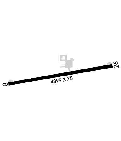
| Lat: N 4131.2 Long: W 08724.0 Elev: 634 Var: +03 Longest Runway: 4899 | ||
| CTAF: 123.0 | ||
| ||||||||||||||||||||||||||||||||||||||||||||
| ||||||||||||||||||||||||||||||||||||||||||||
| Rwy | Rwy | |||||||
| 4899x75 | 4899' | 4899x75 | 3779' | |||||
| Runway ID | Single Wheel | Double Wheel | Double Tandem Wheel | Dual Double Wheel |
| 08/26 | N/A | N/A | N/A | N/A |
| These numbers are Advisory and are not limits. The Airport Manager should have more accurate Weight Limits | ||||
 Airport Diagram might not be current. | |
| Facility Name: | GRIFFITH-MERRILLVILLE |
| City Name: | GRIFFITH |
| County: | LAKE |
| State abbrev: | IN |
| State Name: | INDIANA |
| Ownership: | PRIVATELY OWNED |
| Use: | OPEN TO THE PUBLIC |
| Owner's Name: | GRIFFITH AVIATION INC |
| Address: | 1705 E. MAIN ST. |
| GRIFFITH, IN 46319 | |
| Owner's Phone: | 219-924-0207 |
| Manager's Name: | CRAIG ANDERSON |
| Address: | 1705 E. MAIN ST. |
| GRIFFITH, IN 46319 | |
| Phone: | 219-924-0207 |
| FAA Region: | GREAT LAKES |
| FAA Field Office: | CHI |
| Date | Sunrise | Sunset |
|---|---|---|
| 09/24/21 Friday | 6:39 | 18:44 |
| 09/25/21 Saturday | 6:40 | 18:42 |
| 09/26/21 Sunday | 6:41 | 18:40 |
| 09/27/21 Monday | 6:42 | 18:39 |
| 09/28/21 Tuesday | 6:43 | 18:37 |
| 09/29/21 Wednesday | 6:44 | 18:35 |
| 09/30/21 Thursday | 6:45 | 18:33 |
| 10/01/21 Friday | 6:46 | 18:32 |
| 10/02/21 Saturday | 6:47 | 18:30 |
| 10/03/21 Sunday | 6:48 | 18:28 |
| 10/04/21 Monday | 6:49 | 18:27 |
| 10/05/21 Tuesday | 6:50 | 18:25 |
| 10/06/21 Wednesday | 6:51 | 18:23 |
| 10/07/21 Thursday | 6:53 | 18:22 |
| Airport Attendance Schedule | MON-FRI 0800-2000, SAT-SUN 0800-1700; 0800-1900 DURG WINTER MONTHS. |
| Airport Status | OPERATIONAL (This Status can change at any time - please check NOTAMS) |
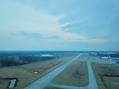
| Airport Lighting Schedule | ACTVT REIL RWY 08 & 26; PAPI RWY 08 & 26; MIRL RWY 08/26 - CTAF. |
| Airport Storage Available | Tie Downs, Hanger |
| Extra Services Available | Flight Instruction, Aircraft Rental, Aircraft Sales |
| Wind Indicator | YES - (lighted) |
| Control Tower | NO |
| CTAF Frequency | 123.000 |
| Unicom Frequency | 123.000 |
| Rotating Beacon Color | CLEAR-GREEN (Light Land Airport) |
| Segmented Circle | NO |
| Landing Fee | NO |
| Airport Inspected | STATE - performed by STATE AERONAUTICAL PERSONNEL |
| Inspection Date | 06/15/2021 |
| Type of Fuel Available | Grade 100LL, JET A (freeze point -40C)UL94 |
| Airframe Repair Service | MAJOR |
| Power Plant Repair Service | MAJOR |
| Latitude | N4131.2 |
| Longitude | W08724.0 (ESTIMATED) |
| Arpt Elevation | 634ft (SURVEYED) |
| Magnetic Variation | 03W |
| 2 miles E | of GRIFFITH |
| Traffic Pattern Altitude | |
| Sectional Chart | CHICAGO |
| Operations (Reported) | Yearly | Avg. Daily |
|---|---|---|
| General Aviation Transient | 24686 | 68 |
| General Aviation Local | 3732 | 10 |
| Air Taxi | 287 | 1 |
| Commerical | 0 | 0 |
| Commuter | 0 | 0 |
| Military | 0 | 0 |
| Aircraft based on Field | |
|---|---|
| General Aviation Singles | 35 |
| General Aviation Multi | 9 |
| Jet Aircraft | 1 |
| General Aviation Helicopters | 3 |
| Military Aircraft | 0 |
| Gliders | 0 |
| Ultralights | 0 |
| FSS on field | NO |
| FSS tie-in | TERRE HAUTE |
| FSS Phone | 1-800-WX-BRIEF |
| Who issues Notams | HUF |
| Notam D service at airport | YES |
| ARTCC Name | CHICAGO |
| Airport Certification | |
| Aircraft Rescue & Firefighting Index | None |
| Airport of Entry | No |
| Custom Landing Rights | No |
| Joint Civil/Military | No |
| Military Landing rights | No |
| NATIONAL PLAN OF INTEGRATED AIRPORT SYSTEMS (NPIAS) |
| DEER ON & INVOF ARPT. |
| FOR CD CTC CHICAGO APCH AT 847-289-0926. |
| UNATNDD NEW YEARS, EASTER, THANKSGIVING & CHRISTMAS. |
Airport Communications & Frequencies:
| |||||||||||||||||
| Runway: 08 | Runway: 26 | ||
| Mag heading: | 83° | Mag heading: | 263° |
| Rwy Slope: | -.03% Down | Rwy Slope: | .03% Up |
| Approach: | Approach: | ||
| Pattern: | Left Traffic | Pattern: | Left Traffic |
| Markings: | BASIC | Markings: | BASIC |
| Marking Condition: | GOOD | Marking Condition: | GOOD |
| Arresting Dev: | Arresting Dev: | ||
| Lat & Long: | N4131.1 W08724.5 | Lat. & Long.: | N4131.3 W08723.4 |
| Elev: | 634.0 ft. MSL | Elev: | 632.3 ft. MSL |
| TCH: | 44 ft. AGL | TCH: | 33 ft. AGL |
| Visual Glide Path: | 3.50 degrees | Visual Glide Path: | 4.00 degrees |
| Displaced Threshold: | No | Displaced Threshold: | 1120 feet |
| Touchdown Zone: | YES | Touchdown Zone: | YES |
| Touchdown Elev.: | 634.0 feet | Touchdown Elev.: | 631.9 feet |
| Visual Glide Slope: | 2-Light PAPI on LEFT side of Runway | Visual Glide Slope: | 2-Light PAPI on RIGHT side of Runway |
| RVR Equipment: | RVR Equipment: | ||
| RVV Equipment: | NO | RVV Equipment: | NO |
| Approach Lights: | Approach Lights: | ||
| REIL: | YES | REIL: | YES |
| Centerline Lights: | NO | Centerline Lights: | NO |
| Touchdown lights: | NO | Touchdown lights: | NO |
| Runway Category: | Runway with a Non-precision Approach | Runway Category: | Runway with a Non-precision Approach |
| Declared Distances: | Declared Distances: | ||
| Obstructions: | BLDG | Obstructions: | TREES |
| Marked: | NOT Marked/Lighted | Marked: | NOT Marked/Lighted |
| Clearance slope: | 15:1 | Clearance slope: | 2:1; APCH SLOPE 26:1 FM DTHR; 55 FT TREES 1480 FT FM DTHR. |
| Obstruction height: | 12 feet AGL | Obstruction height: | 55 feet AGL |
| Dist. from runway: | 380 feet | Dist. from runway: | 360 feet |
| Centerline offset: | 125 left of centerline | Centerline offset: | |
| Comments: | Comments: |
Thanks for using FltPlan.com
all rights reserved © 1999-2021 by Flight Plan LLC