
| TISHOMINGO COUNTY BELMONT MS |
| |
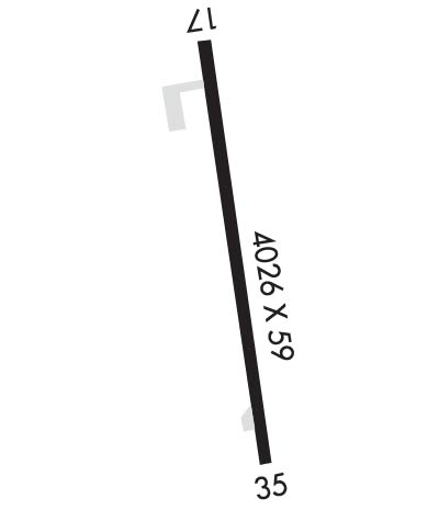
| Lat: N 3429.5 Long: W 08812.1 Elev: 584 Var: -01 Longest Runway: 4007 | ||
| AWOS: 119.3 CTAF: 122.8 | ||
| ||||||
| ||||||
|
| Rwy | Rwy | |||||||
| 4007x60 | 3512' | 4007x60 | 4007' | |||||
| Runway ID | Single Wheel | Double Wheel | Double Tandem Wheel | Dual Double Wheel |
| 17/35 | 20,000 | N/A | N/A | N/A |
| These numbers are Advisory and are not limits. The Airport Manager should have more accurate Weight Limits | ||||
| FltPlan does not have IFR approach charts available for K01M. |
 Airport Diagram might not be current. | |
| Facility Name: | TISHOMINGO COUNTY |
| City Name: | BELMONT |
| County: | TISHOMINGO |
| State abbrev: | MS |
| State Name: | MISSISSIPPI |
| Ownership: | PUBLICLY OWNED |
| Use: | OPEN TO THE PUBLIC |
| Owner's Name: | TISHOMINGO COUNTY; MR GREG COLLIER, CHAIRMAN BOARD OF SUPERVISORS. |
| Address: | PO BOX 1008 |
| IUKA, MS 38852 | |
| Owner's Phone: | 662-423-7032 |
| Manager's Name: | SHANE MCDONALD |
| Address: | 20 AIRPORT RD |
| IUKA, MS 38827 | |
| Phone: | 662-279-0310 |
| FAA Region: | SOUTHERN |
| FAA Field Office: | JAN |
| Date | Sunrise | Sunset |
|---|---|---|
| 06/12/26 Friday | 5:40 | 20:06 |
| 06/13/26 Saturday | 5:40 | 20:06 |
| 06/14/26 Sunday | 5:40 | 20:07 |
| 06/15/26 Monday | 5:40 | 20:07 |
| 06/16/26 Tuesday | 5:40 | 20:07 |
| 06/17/26 Wednesday | 5:40 | 20:08 |
| 06/18/26 Thursday | 5:40 | 20:08 |
| 06/19/26 Friday | 5:40 | 20:08 |
| 06/20/26 Saturday | 5:40 | 20:08 |
| 06/21/26 Sunday | 5:41 | 20:09 |
| 06/22/26 Monday | 5:41 | 20:09 |
| 06/23/26 Tuesday | 5:41 | 20:09 |
| 06/24/26 Wednesday | 5:41 | 20:09 |
| 06/25/26 Thursday | 5:42 | 20:09 |
| Airport Attendance Schedule | 7 Days A Week UNATNDD; FOR FUEL & SVC AFT HRS CALL 662-279-0310. |
| Airport Status | OPERATIONAL (This Status can change at any time - please check NOTAMS) |
| Airport Lighting Schedule | ACTVT MIRL RWY 17/35 - CTAF. |
| Airport Storage Available | NONE |
| Extra Services Available | NONE |
| Wind Indicator | YES - (lighted) |
| Control Tower | NO |
| CTAF Frequency | 122.800 |
| Unicom Frequency | 122.800 |
| Rotating Beacon Color | WG |
| Segmented Circle | YES |
| Landing Fee | NO |
| Airport Inspected | STATE - performed by STATE AERONAUTICAL PERSONNEL |
| Inspection Date | 10/16/2025 |
| Type of Fuel Available | Grade 100LL; -10FUEL SVC AVBL 24 HRS WITH CREDIT CARD. |
| Airframe Repair Service | NONE |
| Power Plant Repair Service | NONE |
| Latitude | N3429.5 |
| Longitude | W08812.1 (ESTIMATED) |
| Arpt Elevation | 584ft (SURVEYED) |
| Magnetic Variation | 01E |
| 2 miles S | of BELMONT |
| Traffic Pattern Altitude | |
| Sectional Chart | MEMPHIS |
| Operations (Reported) | Yearly | Avg. Daily |
|---|---|---|
| General Aviation Transient | 0 | 0 |
| General Aviation Local | 0 | 0 |
| Air Taxi | 0 | 0 |
| Commerical | 0 | 0 |
| Commuter | 0 | 0 |
| Military | 0 | 0 |
| Aircraft based on Field | |
|---|---|
| General Aviation Singles | 0 |
| General Aviation Multi | 0 |
| Jet Aircraft | 0 |
| General Aviation Helicopters | 0 |
| Military Aircraft | 0 |
| Gliders | 0 |
| Ultralights | 0 |
| FSS on field | NO |
| FSS tie-in | GREENWOOD |
| FSS Phone | 1-800-WX-BRIEF |
| Who issues Notams | GWO |
| Notam D service at airport | YES |
| ARTCC Name | MEMPHIS |
| Airport Certification | |
| Aircraft Rescue & Firefighting Index | None |
| Airport of Entry | No |
| Custom Landing Rights | No |
| Joint Civil/Military | No |
| Military Landing rights | YES |
| NATIONAL PLAN OF INTEGRATED AIRPORT SYSTEMS (NPIAS) |
| ASSURANCES PURSUANT TO TITLE VI, CIVIL RIGHTS ACT OF 1964 |
| GRANT AGREEMENT HAS EXPIRED; HOWEVER, AGREEMENT REMAINS IN EFFECT FOR THIS FACILITY AS LONG AS IT IS PUBLIC USE. |
| FOR CD CTC MEMPHIS ARTCC AT 901-368-8453/8449. |
| COURTESY CAR AVBL. |
| Runway: 17 | Runway: 35 | ||
| Mag heading: | N/A | Mag heading: | N/A |
| Rwy Slope: | -.16% Down | Rwy Slope: | .16% Up |
| Approach: | Approach: | ||
| Pattern: | Left Traffic | Pattern: | Left Traffic |
| Markings: | BASIC | Markings: | BASIC |
| Marking Condition: | GOOD | Marking Condition: | GOOD |
| Arresting Dev: | Arresting Dev: | ||
| Lat & Long: | N3429.8 W08812.2 | Lat. & Long.: | N3429.2 W08812.0 |
| Elev: | 584.0 ft. MSL | Elev: | 577.7 ft. MSL |
| TCH: | TCH: | ||
| Visual Glide Path: | Visual Glide Path: | ||
| Displaced Threshold: | 495 feet | Displaced Threshold: | No |
| Touchdown Zone: | YES | Touchdown Zone: | YES |
| Touchdown Elev.: | 577.4 feet | Touchdown Elev.: | 577.7 feet |
| Visual Glide Slope: | Visual Glide Slope: | ||
| RVR Equipment: | RVR Equipment: | ||
| RVV Equipment: | NO | RVV Equipment: | NO |
| Approach Lights: | Approach Lights: | ||
| REIL: | NO | REIL: | NO |
| Centerline Lights: | NO | Centerline Lights: | NO |
| Touchdown lights: | NO | Touchdown lights: | NO |
| Runway Category: | Runway with a Visual Approach | Runway Category: | Runway with a Visual Approach |
| Declared Distances: | Declared Distances: | ||
| Obstructions: | TREES | Obstructions: | TREE |
| Marked: | NOT Marked/Lighted | Marked: | NOT Marked/Lighted |
| Clearance slope: | 20:1; APCH RATIO 12:1 FM DTHR, 56 FT TREES 125 FT R, 700 FT FM DTHR. | Clearance slope: | 20:1 |
| Obstruction height: | 10 feet AGL | Obstruction height: | 25 feet AGL |
| Dist. from runway: | 400 feet | Dist. from runway: | 700 feet |
| Centerline offset: | 125 right of centerline | Centerline offset: | 200 feet left of centerline |
| Comments: | Comments: |
Thanks for using FltPlan.com
all rights reserved © 1999-2026 by Flight Plan LLC
