| ANIMAS AIR PARK DURANGO CO |
| |
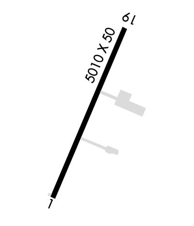
| Lat: N 3712.2 Long: W 10752.2 Elev: 6684 Var: -12 Longest Runway: 5010 | ||
| CTAF: 122.8 | ||
| |||||||||||||||||||||||||||||||||||||||||||||||||||||||||||||
| |||||||||||||||||||||||||||||||||||||||||||||||||||||||||||||
| Rwy | Rwy | |||||||
| 5010x50 | 5010' | 5010x50 | 5010' | |||||
| Runway ID | Single Wheel | Double Wheel | Double Tandem Wheel | Dual Double Wheel |
| 01/19 | N/A | N/A | N/A | N/A |
| These numbers are Advisory and are not limits. The Airport Manager should have more accurate Weight Limits | ||||
| FltPlan does not have IFR approach charts available for K00C. |
 Airport Diagram might not be current. | |
| Facility Name: | ANIMAS AIR PARK |
| City Name: | DURANGO |
| County: | LA PLATA |
| State abbrev: | CO |
| State Name: | COLORADO |
| Ownership: | PRIVATELY OWNED |
| Use: | OPEN TO THE PUBLIC |
| Owner's Name: | AIRPARK PROPERTY OWNERS ASSOC |
| Address: | PO BOX 1797 |
| DURANGO, CO 81302 | |
| Owner's Phone: | 970-247-4632 |
| Manager's Name: | DELVIN GREGG |
| Address: | PO BOX 1797 |
| DURANGO, CO 81302 | |
| Phone: | 970-247-4632 |
| FAA Region: | NORTHWEST MOUNTAIN |
| FAA Field Office: | DEN |
| Date | Sunrise | Sunset |
|---|---|---|
| 09/24/21 Friday | 7:01 | 19:06 |
| 09/25/21 Saturday | 7:02 | 19:04 |
| 09/26/21 Sunday | 7:02 | 19:03 |
| 09/27/21 Monday | 7:03 | 19:01 |
| 09/28/21 Tuesday | 7:04 | 19:00 |
| 09/29/21 Wednesday | 7:05 | 18:58 |
| 09/30/21 Thursday | 7:06 | 18:56 |
| 10/01/21 Friday | 7:07 | 18:55 |
| 10/02/21 Saturday | 7:08 | 18:53 |
| 10/03/21 Sunday | 7:08 | 18:52 |
| 10/04/21 Monday | 7:09 | 18:51 |
| 10/05/21 Tuesday | 7:10 | 18:49 |
| 10/06/21 Wednesday | 7:11 | 18:48 |
| 10/07/21 Thursday | 7:12 | 18:46 |
| Airport Attendance Schedule | 7 Days A Week DALGT |
| Airport Status | OPERATIONAL (This Status can change at any time - please check NOTAMS) |
| Airport Lighting Schedule | ACTVT MIRL RWY 01/19 - 122.9. |
| Airport Storage Available | Tie Downs, Hanger |
| Extra Services Available | Crop Dusting, Air Ambulance, Cargo Handling, Charter, Flight Instruction, Aircraft Rental, Annual Surveying |
| Wind Indicator | YES - (unlit) |
| Control Tower | NO |
| CTAF Frequency | 122.800 |
| Unicom Frequency | 122.800 |
| Rotating Beacon Color | |
| Segmented Circle | YES |
| Landing Fee | NO |
| Airport Inspected | STATE - performed by STATE AERONAUTICAL PERSONNEL |
| Inspection Date | 06/21/2021 |
| Type of Fuel Available | Grade 100LL, JET A (freeze point -40C) |
| Airframe Repair Service | MAJOR |
| Power Plant Repair Service | MAJOR |
| Latitude | N3712.2 |
| Longitude | W10752.2 (ESTIMATED) |
| Arpt Elevation | 6684ft (SURVEYED) |
| Magnetic Variation | 12E |
| 4 miles S | of DURANGO |
| Traffic Pattern Altitude | |
| Sectional Chart | DENVER |
| Operations (Reported) | Yearly | Avg. Daily |
|---|---|---|
| General Aviation Transient | 3670 | 10 |
| General Aviation Local | 7118 | 20 |
| Air Taxi | 162 | 0 |
| Commerical | 0 | 0 |
| Commuter | 0 | 0 |
| Military | 0 | 0 |
| Aircraft based on Field | |
|---|---|
| General Aviation Singles | 44 |
| General Aviation Multi | 1 |
| Jet Aircraft | 0 |
| General Aviation Helicopters | 0 |
| Military Aircraft | 0 |
| Gliders | 0 |
| Ultralights | 0 |
| FSS on field | NO |
| FSS tie-in | DENVER |
| FSS Phone | 1-800-WX-BRIEF |
| Who issues Notams | DEN |
| Notam D service at airport | YES |
| ARTCC Name | DENVER |
| Airport Certification | |
| Aircraft Rescue & Firefighting Index | None |
| Airport of Entry | No |
| Custom Landing Rights | No |
| Joint Civil/Military | No |
| Military Landing rights | No |
| THIS AIRPORT HAS BEEN SURVEYED BY THE NATIONAL GEODETIC SURVEY. |
| CTN: HEL HOSP OPS 2.4 NM NE. |
| FOR CD CTC DENVER ARTCC AT 303-651-4257. |
| RWY 01/1 9 -1 TO - 2 FT DRAINAGE DITCHES 35 FT W & 30 FT E ALG CNTRLN; +4 FT FENCE 87 FT W ALG CNTRLN; +10 FT ROAD 105 FT W ALG CNTRLN. |
| RWY 01 200 FT DROPOFF 120 FT FM & PARALLEL THR; +15 FT TREES 1817 FT FM THR 105 FT L OF CNTRLN. |
| RWY 01/1 9 THR LGTS N END 162 FT FM PAVEMENT END. |
| Runway: 01 | Runway: 19 | ||
| Mag heading: | 9° | Mag heading: | 189° |
| Rwy Slope: | 1.14% Up | Rwy Slope: | -1.14% Down |
| Approach: | Approach: | ||
| Pattern: | Right Traffic | Pattern: | Left Traffic |
| Markings: | BASIC | Markings: | BASIC |
| Marking Condition: | FAIR | Marking Condition: | FAIR |
| Arresting Dev: | Arresting Dev: | ||
| Lat & Long: | N3711.8 W10752.3 | Lat. & Long.: | N3712.6 W10752.0 |
| Elev: | 6626.8 ft. MSL | Elev: | 6684.0 ft. MSL |
| TCH: | TCH: | ||
| Visual Glide Path: | Visual Glide Path: | ||
| Displaced Threshold: | No | Displaced Threshold: | No |
| Touchdown Zone: | YES | Touchdown Zone: | YES |
| Touchdown Elev.: | 6650.5 feet | Touchdown Elev.: | 6684.0 feet |
| Visual Glide Slope: | Visual Glide Slope: | ||
| RVR Equipment: | RVR Equipment: | ||
| RVV Equipment: | NO | RVV Equipment: | NO |
| Approach Lights: | Approach Lights: | ||
| REIL: | NO | REIL: | NO |
| Centerline Lights: | NO | Centerline Lights: | NO |
| Touchdown lights: | NO | Touchdown lights: | NO |
| Runway Category: | Runway with a Visual Approach | Runway Category: | Runway with a Visual Approach |
| Declared Distances: | Declared Distances: | ||
| Obstructions: | Obstructions: | BRUSH | |
| Marked: | Marked: | NOT Marked/Lighted | |
| Clearance slope: | 50:1 | Clearance slope: | 5:1 |
| Obstruction height: | Obstruction height: | 20 feet AGL | |
| Dist. from runway: | Dist. from runway: | 333 feet | |
| Centerline offset: | Centerline offset: | 98 feet right of centerline | |
| Comments: | +32 FT HNGR 1495 FT FM THR 100 FT R OF CNTRLN. | Comments: | +10 FT ROAD AT THR 25 L OF CNTRLN; +16 FT TREE 116 FT FM THR 90 FT R OF CNTRLN; +11 FT TREE 41 FT FM THR 78 FT R OF CNTRLN; +9 FT TREE 73 FT FM THR 74 L OF CNTRLN. |
Thanks for using FltPlan.com
all rights reserved © 1999-2021 by Flight Plan LLC