
| PERKINS FIELD OVERTON NV |
| |
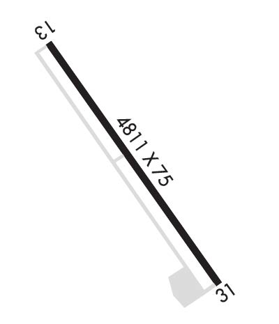
| Lat: N 3634.1 Long: W 11426.6 Elev: 1366 Var: -14 Longest Runway: 4811 | ||
| CTAF: 122.8 | ||
| ||||||||||||||||||||||||||||||||||||||||||||
| ||||||||||||||||||||||||||||||||||||||||||||
| Rwy | Rwy | |||||||
| 4811x75 | 4811' | 4811x75 | 4811' | |||||
| Runway ID | Single Wheel | Double Wheel | Double Tandem Wheel | Dual Double Wheel |
| 13/31 | 30,000 | N/A | N/A | N/A |
| These numbers are Advisory and are not limits. The Airport Manager should have more accurate Weight Limits | ||||
| FltPlan does not have IFR approach charts available for KU08. |
 Airport Diagram might not be current. | |
| Facility Name: | PERKINS FLD |
| City Name: | OVERTON |
| County: | CLARK |
| State abbrev: | NV |
| State Name: | NEVADA |
| Ownership: | PUBLICLY OWNED |
| Use: | OPEN TO THE PUBLIC |
| Owner's Name: | CLARK COUNTY |
| Address: | PO BOX 11005 |
| LAS VEGAS, NV 89111-1005 | |
| Owner's Phone: | 702-261-3802 |
| Manager's Name: | WINNIE STA ANA |
| Address: | 2730 AIRPORT DRIVE STE. 101 |
| NORTH LAS VEGAS, NV 89032 | |
| Phone: | 702-261-3805 |
| FAA Region: | WESTERN-PACIFIC |
| FAA Field Office: | PHX |
| Date | Sunrise | Sunset |
|---|---|---|
| 04/22/24 Monday | 5:54 | 19:19 |
| 04/23/24 Tuesday | 5:53 | 19:20 |
| 04/24/24 Wednesday | 5:51 | 19:21 |
| 04/25/24 Thursday | 5:50 | 19:22 |
| 04/26/24 Friday | 5:49 | 19:22 |
| 04/27/24 Saturday | 5:48 | 19:23 |
| 04/28/24 Sunday | 5:47 | 19:24 |
| 04/29/24 Monday | 5:46 | 19:25 |
| 04/30/24 Tuesday | 5:44 | 19:26 |
| 05/01/24 Wednesday | 5:43 | 19:27 |
| 05/02/24 Thursday | 5:42 | 19:28 |
| 05/03/24 Friday | 5:41 | 19:29 |
| 05/04/24 Saturday | 5:40 | 19:29 |
| 05/05/24 Sunday | 5:39 | 19:30 |
| Airport Attendance Schedule | THUR-MON DALGT; TUE & WED SVC AVBL ON CALL (702) 397-8457. |
| Airport Status | OPERATIONAL (This Status can change at any time - please check NOTAMS) |
| Airport Lighting Schedule | ACTVT MIRLS RY 13/31 - CTAF. |
| Airport Storage Available | Tie Downs |
| Extra Services Available | Air Ambulance, Glider, Parachute Jumping |
| Wind Indicator | YES - (lighted) |
| Control Tower | NO |
| CTAF Frequency | 122.800; ONLY ENOUGH OIL FOR ENG NEED, NO EXTRA SALES AVAILABLE. |
| Unicom Frequency | 122.800 |
| Rotating Beacon Color | WG |
| Segmented Circle | YES |
| Landing Fee | NO |
| Airport Inspected | STATE - performed by STATE AERONAUTICAL PERSONNEL |
| Inspection Date | 05/17/2023 |
| Type of Fuel Available | Grade 100LL |
| Airframe Repair Service | NONE |
| Power Plant Repair Service | NONE |
| Latitude | N3634.1 |
| Longitude | W11426.6 (ESTIMATED) |
| Arpt Elevation | 1365ft (SURVEYED) |
| Magnetic Variation | 14E |
| 2 miles N | of OVERTON |
| Traffic Pattern Altitude | 800 |
| Sectional Chart | LAS VEGAS |
| Operations (Reported) | Yearly | Avg. Daily |
|---|---|---|
| General Aviation Transient | 3626 | 10 |
| General Aviation Local | 3700 | 10 |
| Air Taxi | 0 | 0 |
| Commerical | 0 | 0 |
| Commuter | 0 | 0 |
| Military | 180 | 0 |
| Aircraft based on Field | |
|---|---|
| General Aviation Singles | 16 |
| General Aviation Multi | 1 |
| Jet Aircraft | 0 |
| General Aviation Helicopters | 0 |
| Military Aircraft | 0 |
| Gliders | 0 |
| Ultralights | 0 |
| FSS on field | NO |
| FSS tie-in | RENO |
| FSS Phone | 1-800-WX-BRIEF |
| Who issues Notams | RNO |
| Notam D service at airport | YES |
| ARTCC Name | LOS ANGELES |
| Airport Certification | |
| Aircraft Rescue & Firefighting Index | None |
| Airport of Entry | No |
| Custom Landing Rights | No |
| Joint Civil/Military | No |
| Military Landing rights | No |
| NATIONAL PLAN OF INTEGRATED AIRPORT SYSTEMS (NPIAS) |
| GRANT AGREEMENTS UNDER FAAP/ADAP/AIP |
| ASSURANCES PURSUANT TO TITLE VI, CIVIL RIGHTS ACT OF 1964 |
| ULTRALIGHT AND SKYDIVING ACTIVITY ONGOING ON OR NEAR THE ARPT. |
| SKYDIVING ACT ON/INVOF ARPT DLY SR-SS. |
| FOR CD CTC LOS ANGELES ARTCC AT 661-575-2079. |
| Runway: 13 | Runway: 31 | ||
| Mag heading: | 136° | Mag heading: | 316° |
| Rwy Slope: | -.36% Down | Rwy Slope: | .36% Up |
| Approach: | Approach: | ||
| Pattern: | Left Traffic | Pattern: | Right Traffic |
| Markings: | NONPRECISION INSTRUMENT | Markings: | NONPRECISION INSTRUMENT |
| Marking Condition: | FAIR | Marking Condition: | FAIR |
| Arresting Dev: | Arresting Dev: | ||
| Lat & Long: | N3634.4 W11426.8 | Lat. & Long.: | N3633.7 W11426.4 |
| Elev: | 1365.9 ft. MSL | Elev: | 1348.8 ft. MSL |
| TCH: | TCH: | ||
| Visual Glide Path: | Visual Glide Path: | ||
| Displaced Threshold: | No | Displaced Threshold: | No |
| Touchdown Zone: | YES | Touchdown Zone: | YES |
| Touchdown Elev.: | 1365.9 feet | Touchdown Elev.: | 1356.5 feet |
| Visual Glide Slope: | Visual Glide Slope: | ||
| RVR Equipment: | RVR Equipment: | ||
| RVV Equipment: | NO | RVV Equipment: | NO |
| Approach Lights: | Approach Lights: | ||
| REIL: | NO | REIL: | NO |
| Centerline Lights: | NO | Centerline Lights: | NO |
| Touchdown lights: | NO | Touchdown lights: | NO |
| Runway Category: | Runway with a Visual Approach | Runway Category: | Runway with a Visual Approach |
| Declared Distances: | Declared Distances: | ||
| Obstructions: | FENCE | Obstructions: | ROAD |
| Marked: | NOT Marked/Lighted | Marked: | NOT Marked/Lighted |
| Clearance slope: | 45:1 | Clearance slope: | 10:1 |
| Obstruction height: | 4 feet AGL | Obstruction height: | 15 feet AGL |
| Dist. from runway: | 380 feet | Dist. from runway: | 360 feet |
| Centerline offset: | Centerline offset: | ||
| Comments: | Comments: |
Thanks for using FltPlan.com
all rights reserved © 1999-2024 by Flight Plan LLC
