
| HARVEY FIELD SNOHOMISH WA |
| |
| Lat: N 4754.3 Long: W 12206.2 Elev: 23 Var: -17 Longest Runway: 2672 | ||
| CTAF: 123.0 | ||
| ||||||||||||||||||||||||||||||||||||||||||||
| ||||||||||||||||||||||||||||||||||||||||||||
| Rwy | Rwy | |||||||
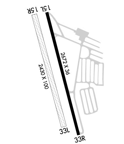
| 2672x36 | 2220' | 2672x36 | 2430' | |||||
| 2430x100 | 2430' | 2430x100 | 2430' | |||||
| Runway ID | Single Wheel | Double Wheel | Double Tandem Wheel | Dual Double Wheel |
| 15L/33R | 10,000 | N/A | N/A | N/A |
| 15R/33L | N/A | N/A | N/A | N/A |
| These numbers are Advisory and are not limits. The Airport Manager should have more accurate Weight Limits | ||||
 Airport Diagram might not be current. | |
| Facility Name: | HARVEY FLD |
| City Name: | SNOHOMISH |
| County: | SNOHOMISH |
| State abbrev: | WA |
| State Name: | WASHINGTON |
| Ownership: | PRIVATELY OWNED |
| Use: | OPEN TO THE PUBLIC |
| Owner's Name: | K HARVEY |
| Address: | 9900 AIRPORT WAY |
| SNOHOMISH, WA 98296 | |
| Owner's Phone: | 360-568-1541 |
| Manager's Name: | CYNTHIA HENDRICKSON |
| Address: | 9900 AIRPORT WAY |
| SNOHOMISH, WA 98296 | |
| Phone: | 360-568-1541 |
| FAA Region: | NORTHWEST MOUNTAIN |
| FAA Field Office: | SEA |

| Date | Sunrise | Sunset |
|---|---|---|
| 05/03/24 Friday | 5:46 | 20:25 |
| 05/04/24 Saturday | 5:44 | 20:27 |
| 05/05/24 Sunday | 5:43 | 20:28 |
| 05/06/24 Monday | 5:41 | 20:29 |
| 05/07/24 Tuesday | 5:40 | 20:31 |
| 05/08/24 Wednesday | 5:38 | 20:32 |
| 05/09/24 Thursday | 5:37 | 20:34 |
| 05/10/24 Friday | 5:35 | 20:35 |
| 05/11/24 Saturday | 5:34 | 20:36 |
| 05/12/24 Sunday | 5:33 | 20:37 |
| 05/13/24 Monday | 5:31 | 20:39 |
| 05/14/24 Tuesday | 5:30 | 20:40 |
| 05/15/24 Wednesday | 5:29 | 20:41 |
| 05/16/24 Thursday | 5:28 | 20:43 |
| Airport Attendance Schedule | NOV-MAR 7 Days A Week 0730-1630, APR-OCT 7 Days A Week 0730-2100 |
| Airport Status | OPERATIONAL (This Status can change at any time - please check NOTAMS) |
| Airport Lighting Schedule | SS-SR |
| Airport Storage Available | Tie Downs, Hanger |
| Extra Services Available | Charter, Flight Instruction, Parachute Jumping, Aircraft Rental, Aircraft Sales |
| Wind Indicator | YES - (unlit) |
| Control Tower | NO |
| CTAF Frequency | 123.000 |
| Unicom Frequency | 123.000 |
| Rotating Beacon Color | |
| Segmented Circle | NO; NON STD TRAFFIC PATTERN INDICATOR LCTD NEAR WIND CONE. |
| Landing Fee | NO |
| Airport Inspected | STATE - performed by STATE AERONAUTICAL PERSONNEL |
| Inspection Date | 07/20/2023 |
| Type of Fuel Available | Grade 100LL, JET A (freeze point -40C); -10FUEL 24 HR CREDIT CARD SVC AVBL. |
| Airframe Repair Service | MAJOR |
| Power Plant Repair Service | MAJOR |
| Latitude | N4754.3 |
| Longitude | W12206.2 (ESTIMATED) |
| Arpt Elevation | 22ft (SURVEYED) |
| Magnetic Variation | 17E |
| 1 miles SW | of SNOHOMISH |
| Traffic Pattern Altitude | 984 |
| Sectional Chart | SEATTLE |
| Operations (Reported) | Yearly | Avg. Daily |
|---|---|---|
| General Aviation Transient | 46600 | 128 |
| General Aviation Local | 51920 | 142 |
| Air Taxi | 1500 | 4 |
| Commerical | 0 | 0 |
| Commuter | 0 | 0 |
| Military | 200 | 1 |
| Aircraft based on Field | |
|---|---|
| General Aviation Singles | 187 |
| General Aviation Multi | 3 |
| Jet Aircraft | 0 |
| General Aviation Helicopters | 5 |
| Military Aircraft | 0 |
| Gliders | 1 |
| Ultralights | 1 |
| FSS on field | NO |
| FSS tie-in | SEATTLE |
| FSS Phone | 1-800-WX-BRIEF |
| Who issues Notams | SEA |
| Notam D service at airport | YES |
| ARTCC Name | SEATTLE |
| Airport Certification | |
| Aircraft Rescue & Firefighting Index | None |
| Airport of Entry | No |
| Custom Landing Rights | No |
| Joint Civil/Military | No |
| Military Landing rights | YES |
| NATIONAL PLAN OF INTEGRATED AIRPORT SYSTEMS (NPIAS) |
| ADDITIONAL PARACHUTE STUDENT DROP ZONE 1 NM E OF ARPT MKD WITH WHITE 'X'. ARRIVING HELICOPTER TRAFFIC APPROACH HELIPADS FROM NE OR SE TO AVOID STUDENT DROP ZONE. |
| RYS 15L & 15R CALM WIND RYS. |
| PARACHUTE DROP ZONE BETWEEN RY 15L/33R AND MAIN TWY, LARGE GRAVEL CIRCLE. |
| FOR CD CTC SEATTLE APCH AT 206-214-4722. |
| NOISE ABATEMENT PROCEDURES IN EFFECT; CTC AMGR 360-568-1541. |
| HELICOPTER TRNG WEST OF RYS 500 FT & BLO. |
| RWY 15R/ 33LCLOSED NOV 1 - MAY 31. |
| RWY 15L/ 33RNSTD LIRL; THLD LIGHTS 360 DEGS GREEN. |
Airport Communications & Frequencies:
| ||||||||||||||
| Runway: 15L | Runway: 33R | ||
| Mag heading: | 148° | Mag heading: | 328° |
| Rwy Slope: | .27% Up | Rwy Slope: | -.27% Down |
| Approach: | Approach: | ||
| Pattern: | Right Traffic | Pattern: | Left Traffic |
| Markings: | NUMBERS ONLY | Markings: | NUMBERS ONLY |
| Marking Condition: | GOOD | Marking Condition: | GOOD |
| Arresting Dev: | Arresting Dev: | ||
| Lat & Long: | N4754.5 W12206.2 | Lat. & Long.: | N4754.1 W12206.1 |
| Elev: | 15.3 ft. MSL | Elev: | 22.6 ft. MSL |
| TCH: | TCH: | ||
| Visual Glide Path: | Visual Glide Path: | ||
| Displaced Threshold: | 452 feet | Displaced Threshold: | 242 feet |
| Touchdown Zone: | YES | Touchdown Zone: | YES |
| Touchdown Elev.: | 21.5 feet | Touchdown Elev.: | 21.5 feet |
| Visual Glide Slope: | Visual Glide Slope: | ||
| RVR Equipment: | RVR Equipment: | ||
| RVV Equipment: | NO | RVV Equipment: | NO |
| Approach Lights: | Approach Lights: | ||
| REIL: | NO | REIL: | NO |
| Centerline Lights: | NO | Centerline Lights: | NO |
| Touchdown lights: | NO | Touchdown lights: | NO |
| Runway Category: | Runway with a Visual Approach | Runway Category: | Runway with a Visual Approach |
| Declared Distances: | Declared Distances: | ||
| Obstructions: | TREES | Obstructions: | TREES |
| Marked: | NOT Marked/Lighted | Marked: | NOT Marked/Lighted |
| Clearance slope: | 7:1; APCH SLOPE 14:1 TO +40 FT PLINE 590 FT FM DSPLCD THLD. | Clearance slope: | 13:1; APCH SLOPE 6:1 FROM DSPLCD THLD. |
| Obstruction height: | 80 feet AGL | Obstruction height: | 97 feet AGL |
| Dist. from runway: | 796 feet | Dist. from runway: | 1537 feet |
| Centerline offset: | 97 left of centerline | Centerline offset: | 125 feet right of centerline |
| Comments: | HI VOLTAGE P-LINE 22 FT HIGH 32 FT FM AER 15 & 25 FT FM MARKER LINE AT 106 FT, RAILROAD AT 200FT. | Comments: | RD 50' FM THR; +10' FNC POSTS WITH RED LGTS 50' FM THR; 10' LINE WITH LGTS & FLAGS AT 80'. |
| Runway: 15R | Runway: 33L | ||
| Mag heading: | 148° | Mag heading: | 328° |
| Rwy Slope: | .29% Up | Rwy Slope: | -.29% Down |
| Approach: | Approach: | ||
| Pattern: | Right Traffic | Pattern: | Left Traffic |
| Markings: | NONE | Markings: | NONE |
| Marking Condition: | FAIR | Marking Condition: | FAIR |
| Arresting Dev: | Arresting Dev: | ||
| Lat & Long: | N4754.5 W12206.3 | Lat. & Long.: | N4754.1 W12206.1 |
| Elev: | 15.4 ft. MSL | Elev: | 22.4 ft. MSL |
| TCH: | TCH: | ||
| Visual Glide Path: | Visual Glide Path: | ||
| Displaced Threshold: | No | Displaced Threshold: | No |
| Touchdown Zone: | YES | Touchdown Zone: | YES |
| Touchdown Elev.: | 22.4 feet | Touchdown Elev.: | 22.4 feet |
| Visual Glide Slope: | Visual Glide Slope: | ||
| RVR Equipment: | RVR Equipment: | ||
| RVV Equipment: | NO | RVV Equipment: | NO |
| Approach Lights: | Approach Lights: | ||
| REIL: | NO | REIL: | NO |
| Centerline Lights: | NO | Centerline Lights: | NO |
| Touchdown lights: | NO | Touchdown lights: | NO |
| Runway Category: | Runway with a Visual Approach | Runway Category: | Runway with a Visual Approach |
| Declared Distances: | Declared Distances: | ||
| Obstructions: | TREES | Obstructions: | TREES |
| Marked: | NOT Marked/Lighted | Marked: | NOT Marked/Lighted |
| Clearance slope: | 18:1; APCH SLOPE 14:1 FM DSPLCD THR. | Clearance slope: | 24:1; APCH SLOPE 6:1 FROM DSPLCD THLD. |
| Obstruction height: | 67 feet AGL | Obstruction height: | 110 feet AGL |
| Dist. from runway: | 1267 feet | Dist. from runway: | 2659 feet |
| Centerline offset: | 125 right of centerline | Centerline offset: | |
| Comments: | Comments: |
Thanks for using FltPlan.com
all rights reserved © 1999-2024 by Flight Plan LLC