
| CREST AIRPARK KENT WA |
| |
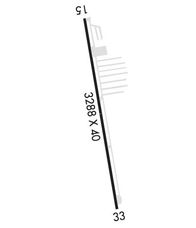
| Lat: N 4720.2 Long: W 12206.2 Elev: 472 Var: -20 Longest Runway: 3288 | ||
| CTAF: 123.0 | ||
| |||||||||||||||||||||||||||||||||||||||||||||||||||||||||||||
| |||||||||||||||||||||||||||||||||||||||||||||||||||||||||||||
| Rwy | Rwy | |||||||
| 3288x40 | 3288' | 3288x40 | 3007' | |||||
| Runway ID | Single Wheel | Double Wheel | Double Tandem Wheel | Dual Double Wheel |
| 15/33 | 12,000 | N/A | N/A | N/A |
| These numbers are Advisory and are not limits. The Airport Manager should have more accurate Weight Limits | ||||
| FltPlan does not have IFR approach charts available for KS36. |
 Airport Diagram might not be current. | |
| Facility Name: | NORMAN GRIER FLD |
| City Name: | KENT |
| County: | KING |
| State abbrev: | WA |
| State Name: | WASHINGTON |
| Ownership: | PRIVATELY OWNED |
| Use: | OPEN TO THE PUBLIC |
| Owner's Name: | GRIER FAMILY HOLDINGS, LLC |
| Address: | 29300 179 PLACE SE |
| KENT, WA 98042 | |
| Owner's Phone: | 253-631-7100 |
| Manager's Name: | RIKKI BIRGE |
| Address: | 29300 179TH PLACE SE |
| KENT, WA 98042 | |
| Phone: | 253-631-7100 |
| FAA Region: | NORTHWEST MOUNTAIN |
| FAA Field Office: | SEA |
| Date | Sunrise | Sunset |
|---|---|---|
| 04/22/24 Monday | 6:06 | 20:09 |
| 04/23/24 Tuesday | 6:04 | 20:10 |
| 04/24/24 Wednesday | 6:02 | 20:11 |
| 04/25/24 Thursday | 6:00 | 20:13 |
| 04/26/24 Friday | 5:59 | 20:14 |
| 04/27/24 Saturday | 5:57 | 20:16 |
| 04/28/24 Sunday | 5:55 | 20:17 |
| 04/29/24 Monday | 5:54 | 20:18 |
| 04/30/24 Tuesday | 5:52 | 20:20 |
| 05/01/24 Wednesday | 5:51 | 20:21 |
| 05/02/24 Thursday | 5:49 | 20:22 |
| 05/03/24 Friday | 5:47 | 20:24 |
| 05/04/24 Saturday | 5:46 | 20:25 |
| 05/05/24 Sunday | 5:44 | 20:26 |
| Airport Attendance Schedule | 7 Days A Week 0900-1700 |
| Airport Status | OPERATIONAL (This Status can change at any time - please check NOTAMS) |
| Airport Lighting Schedule | |
| Airport Storage Available | Tie Downs |
| Extra Services Available | Flight Instruction, Aircraft Rental |
| Wind Indicator | YES - (lighted) |
| Control Tower | NO |
| CTAF Frequency | 123.000 |
| Unicom Frequency | 123.000 |
| Rotating Beacon Color | WG |
| Segmented Circle | NO |
| Landing Fee | NO |
| Airport Inspected | CONTRACTOR - performed by STATE AERONAUTICAL PERSONNEL |
| Inspection Date | 07/13/2023 |
| Type of Fuel Available | Grade 100LL; -1024 HR CREDIT CARD FUEL AVBL. |
| Airframe Repair Service | MAJOR |
| Power Plant Repair Service | MAJOR |
| Latitude | N4720.2 |
| Longitude | W12206.2 (ESTIMATED) |
| Arpt Elevation | 472ft (ESTIMATED) |
| Magnetic Variation | 20E |
| 5 miles SE | of KENT |
| Traffic Pattern Altitude | |
| Sectional Chart | SEATTLE |
| Operations (Reported) | Yearly | Avg. Daily |
|---|---|---|
| General Aviation Transient | 101200 | 277 |
| General Aviation Local | 12650 | 35 |
| Air Taxi | 0 | 0 |
| Commerical | 0 | 0 |
| Commuter | 0 | 0 |
| Military | 0 | 0 |
| Aircraft based on Field | |
|---|---|
| General Aviation Singles | 327 |
| General Aviation Multi | 5 |
| Jet Aircraft | 0 |
| General Aviation Helicopters | 0 |
| Military Aircraft | 0 |
| Gliders | 0 |
| Ultralights | 0 |
| FSS on field | NO |
| FSS tie-in | SEATTLE |
| FSS Phone | 1-800-WX-BRIEF |
| Who issues Notams | SEA |
| Notam D service at airport | YES |
| ARTCC Name | SEATTLE |
| Airport Certification | |
| Aircraft Rescue & Firefighting Index | None |
| Airport of Entry | No |
| Custom Landing Rights | No |
| Joint Civil/Military | No |
| Military Landing rights | YES |
| TREES BOTH SIDES OF RWY IN TRSN SFC. |
| TREES ON BOTH SIDES OF RWY 15/33. |
| NIGHT OPS USE RWY 15, WIND AND WX PMTG. |
| ARPT CLSD WHEN SNOW ON RWY. |
| FOR CD CTC SEATTLE APCH AT 206-214-4723. |
| TGLS PROHIBITED. |
| RWY 15 1 15/33 NSTD MARKINGS NRS & CNTRLN ONLY; FADED. |
| Runway: 15 | Runway: 33 | ||
| Mag heading: | N/A | Mag heading: | N/A |
| Approach: | Approach: | ||
| Pattern: | Left Traffic | Pattern: | Left Traffic |
| Markings: | NONSTANDARD | Markings: | NONSTANDARD |
| Marking Condition: | POOR; MARKINGS FADED. | Marking Condition: | POOR; MARKINGS FADED. |
| Arresting Dev: | Arresting Dev: | ||
| Lat & Long: | N4720.5 W12206.3 | Lat. & Long.: | N4720.0 W12206.1 |
| Elev: | N/A | Elev: | N/A |
| TCH: | TCH: | ||
| Visual Glide Path: | Visual Glide Path: | ||
| Displaced Threshold: | No | Displaced Threshold: | 281 feet |
| Touchdown Zone: | NO | Touchdown Zone: | NO |
| Touchdown Elev.: | Touchdown Elev.: | ||
| Visual Glide Slope: | Visual Glide Slope: | ||
| RVR Equipment: | RVR Equipment: | ||
| RVV Equipment: | NO | RVV Equipment: | NO |
| Approach Lights: | Approach Lights: | ||
| REIL: | NO | REIL: | NO |
| Centerline Lights: | NO | Centerline Lights: | NO |
| Touchdown lights: | NO | Touchdown lights: | NO |
| Runway Category: | Runway with a Visual Approach | Runway Category: | Runway with a Visual Approach |
| Declared Distances: | Declared Distances: | ||
| Obstructions: | TREES | Obstructions: | TREES |
| Marked: | NOT Marked/Lighted | Marked: | NOT Marked/Lighted |
| Clearance slope: | 9:1 | Clearance slope: | 12:1; RWY 33 APPROACH RATIO 6:1 FROM DSPLCD THR. |
| Obstruction height: | 76 feet AGL | Obstruction height: | 107 feet AGL |
| Dist. from runway: | 901 feet | Dist. from runway: | 1560 feet |
| Centerline offset: | Centerline offset: | ||
| Comments: | TREES IN PRIM SFC, PARKED ACFT IN PRIM SFC BOTH SIDES OF RWY AND 3 FT SIGN, 92 FT LEFT, 27 FT FROM THR. | Comments: | +95 FT TREES IN PRI SFC 0-200 FT FM THR, 120 FT RIGHT. |
Thanks for using FltPlan.com
all rights reserved © 1999-2024 by Flight Plan LLC

