NOTICE: Information listed below may not be current.Airport Ident: MMVR
| Airport Name: GENERAL HERIBERTO JARA INTL, Mexico
Location: Veracruz
Latitude: N1908.8 Longitude: W09611.2
Field Elevation: 90' Variation: E5° as of 01/06
Time Zone: UTC-6(-5DT)
Daylight Savings: First Sunday in April to the last Saturday in October
Customs: Airport Of Entry
|
|
| DISTANCE from: | KTEB to MMVR = 1727 nm
| KMIA to MMVR = 967 nm
| KORD to MMVR = 1434 nm
| KDAL to MMVR = 824 nm
| KSEA to MMVR = 2124 nm
| KLAX to MMVR = 1482 nm
|
|
| AIRPORT TYPE: | | Active, joint (civil and military) use. Airports jointly controlled, used and/or operated by both civil and military agencies. The military agencies must be permanent operational flight line type tenants, with or without aircraft stationed on the airport. Minimum facilities are available which include: control tower (or some similar control system, such as a Flight Service Station which issues clearances and advisories when there is no tower or the tower is not in operation), lighting (may be flare pots, etc.), petrol, oils and lubricants (POL), and facilities for organizational maintenance or better. |
|
Rotating Beacon: YES
|
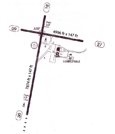
| RUNWAY INFORMATION: | Runway Ident: 27 /09
Runway Length: 4997
Runway Width: 148
Runway Surface: ASPHALT, ASPHALTIC CONCRETE, TAR MACADAM, OR BITUMEN BOUND MACADAM (INCLUDING ANY OF THESE SURFACE TYPES WITH CONCRETE ENDS).
Runway PCN Rating: 010FCYT - Flexible, Subgrade-LOW, Tire Pressure-LOW LIMITED TO 145 PSI
Runway PCN Evaluation Method: Technical Evaluation.
Runway Open: YES
| Runway 27 Information
Runway True Heading: 281°
Takeoff Distance Available: 4997
Landing Distance Available: 4997
Runway Latitude: N1908.6
Runway Longitude: W09610.7
Runway Elevation:
Runway Slope: N/A
Runway TDZE:
Runway Lighting:
| Runway 09 Information
Runway True Heading: 101°
Takeoff Distance Available: 4997
Landing Distance Available: 4997
Runway Latitude: N1908.8
Runway Longitude: W09611.5
Runway Elevation:
Runway Slope: N/A
Runway TDZE: N/A
Runway Lighting:
|
Runway Ident: 36 /18
Runway Length: 7874
Runway Width: 148
Runway Surface: ASPHALT, ASPHALTIC CONCRETE, TAR MACADAM, OR BITUMEN BOUND MACADAM (INCLUDING ANY OF THESE SURFACE TYPES WITH CONCRETE ENDS).
Runway PCN Rating: 064FBXT - Flexible, Subgrade-MEDIUM, Tire Pressure-MEDIUM LIMITED TO 217 PSI
Runway PCN Evaluation Method: Technical Evaluation.
Runway Open: YES
| Runway 36 Information
Runway True Heading: 11°
Takeoff Distance Available: 7874
Landing Distance Available: 7874
Runway Latitude: N1907.7
Runway Longitude: W09611.4
Runway Elevation:
Runway Slope: N/A
Runway TDZE: 90'
Runway Lighting:
| Runway 18 Information
Runway True Heading: 191°
Takeoff Distance Available: 8064
Landing Distance Available: 7874
Runway Latitude: N1909.0
Runway Longitude: W09611.2
Runway Elevation:
Runway Slope: N/A
Runway TDZE: 90
Runway Lighting:
|
|
|
COMMUNICATION INFORMATION
APPROACH CONTROL - VERACRUZ APP
120.4
AUTOMATIC TERMINAL INFORMATION SERVICE - ATIS
127.8
TOWER - VERACRUZ TWR
118.5
|
AIRPORT NAVAIDS
VER - VERACRUZ (VOR-DME) - ON FIELD
|
STANDARD INSTRUMENT DEPARTURE INFORMATION (SIDs)
RW18
RW36
|
TERMINAL AREA REMARKS
RW18 Min holding alt 2000'. DEPARTURE ROUTE DESCRIPTION: AVTUX ONE, LEXUR ONE: Climb on VER R-184 to 10 DME. Proceed on VER R-184 to LEXUR int, or turn left heading 158 and intercept VER R-175 to AVTUX int. Continue on the assigned route, or according to instructionf rom ATC. AXELI ONE ALPHA, IMARA ONE, IPTAK ONE, OTILO ONE: Climb on VER R-184 TO 7 DME. Turn left and proceed on the VER 10 DME arc. Intercept the VER VOR/DME r adial corresponding with the AXELI int, IMARA int, IPTAK int, or OTILO int. Cont inue on the assigned route or according to instructions from ATC. URSOT ONE: Cli mb on VER R-184 TO 7 DME, turn right and proceed on the VER 10 DME arc to interc ept VER R-264 to URSOT int. Continue on the assigned route or according to ATC i nstructions. VERACRUZ TWO ALPHA: Climb on VER R-184 until 7 DME (In case DME f ails until reaching 1300), make a left tear drop turn within 10 NM toward VER VO R/DME and depart VER according to the MCA of the assigned route or ATC instructi ons.
RW36 Min holding alt 2000'. DEPARTURE ROUTE DESCRIPTION: AMORA ONE: Climb on VER R-009 to 12 DME, then proce ed on heading 320 to intercept VER R-355 to AMORA int. Continue on assigned rou te or according to ATC instruction. AXELI ONE BRAVO, BOLTA ONE, ETNAS ONE: Climb on VER R-009 to VER 7 DME. Turn right and proceed on the VER 10 DME arc. Interc ept the VER VOR/DME radial corresponding with the AXELI int, BOLTA int, or ETNAS int. Continue on the assigned route or according to ATC instruction. AXORO ONE: Climb on VER R-009 to 7 DME, turn left and proceed on the VER 10 DME arc. Inter cept VER R-326 to AXORO int. Continue on assigned route or according to ATC inst ruction. VERACRUZ TWO BRAVO: Climb on VER R-009 to 7 DME(In case DME fails until reaching 1400), make a left teardrop turn within 10 NM to VER VOR/DME and depar t VER according to the MCA for assigned route or ATC instruction.
|
CLIMB/DECENT RATE INFORMATION
RWY 18 (RW18) REQUIRES A CLIMB RATE (AT 60 KNOTS) OF 330'/min TO 21000' (URSOT ONE to FL210.)
|
AIRPORT REMARKS
IFR TAKE-OFF MINIMUMS AND DEPARTURE PROCEDURES Diverse departures not authorized. |