
| MARIANNA MUNI MARIANNA FL |
| |
| Lat: N 3050.3 Long: W 08510.9 Elev: 111 Var: +02 Longest Runway: 6001 | ||
| AWOS: 133.52 CTAF: 123.0 | ||
| ||||||||||||||||||||||||||||||||||||||||||||
| ||||||||||||||||||||||||||||||||||||||||||||
| ||||||||||||||||||||||||||||||||||||||||||||
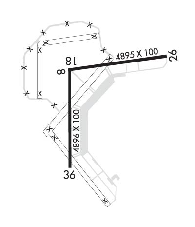
| Rwy | Rwy | |||||||
| 4763x100 | 4763' | 4763x100 | 4763' | |||||
| 6001x100 | 6001' | 6001x100 | 6001' | |||||
| Runway ID | Single Wheel | Double Wheel | Double Tandem Wheel | Dual Double Wheel |
| 08/26 | N/A | N/A | N/A | N/A |
| 18/36 | N/A | N/A | N/A | N/A |
| These numbers are Advisory and are not limits. The Airport Manager should have more accurate Weight Limits | ||||
 Airport Diagram might not be current. | |
| Facility Name: | MARIANNA MUNI |
| City Name: | MARIANNA |
| County: | JACKSON |
| State abbrev: | FL |
| State Name: | FLORIDA |
| Ownership: | PUBLICLY OWNED |
| Use: | OPEN TO THE PUBLIC |
| Owner's Name: | MARIANNA MUNI AIRPORT AUTHORITY; CONTACT PERSON: WILLIAM LONG, CITY MANAGER 850-482-4353. |
| Address: | P.O. BOX 936 |
| MARIANNA, FL 32447 | |
| Owner's Phone: | 850-482- |
| Manager's Name: | DOUG GLASS |
| Address: | MARIANNA MUNICIPAL AIRPORT, 3689 INDUSTRIAL PARK DR |
| MARIANNA, FL 32446 | |
| Phone: | 850-482-2281 |
| FAA Region: | SOUTHERN |
| FAA Field Office: | ORL |
| Date | Sunrise | Sunset |
|---|---|---|
| 04/23/24 Tuesday | 6:04 | 19:15 |
| 04/24/24 Wednesday | 6:03 | 19:15 |
| 04/25/24 Thursday | 6:02 | 19:16 |
| 04/26/24 Friday | 6:01 | 19:17 |
| 04/27/24 Saturday | 6:00 | 19:17 |
| 04/28/24 Sunday | 5:59 | 19:18 |
| 04/29/24 Monday | 5:58 | 19:19 |
| 04/30/24 Tuesday | 5:57 | 19:19 |
| 05/01/24 Wednesday | 5:56 | 19:20 |
| 05/02/24 Thursday | 5:55 | 19:21 |
| 05/03/24 Friday | 5:54 | 19:21 |
| 05/04/24 Saturday | 5:53 | 19:22 |
| 05/05/24 Sunday | 5:52 | 19:23 |
| 05/06/24 Monday | 5:52 | 19:23 |
| Airport Attendance Schedule | MON-FRI 0800-1700; EXCLUDING HOLIDAYS. |
| Airport Status | OPERATIONAL (This Status can change at any time - please check NOTAMS) |
| Airport Lighting Schedule | ACTVT PAPI RWY 18 & 36; MIRL RWY 18/36 - CTAF. |
| Airport Storage Available | Tie Downs, Hanger |
| Extra Services Available | Air Ambulance, Glider, Glider Towing |
| Wind Indicator | YES - (lighted) |
| Control Tower | NO |
| CTAF Frequency | 123.000 |
| Unicom Frequency | 123.000 |
| Rotating Beacon Color | WG |
| Segmented Circle | YES |
| Landing Fee | NO |
| Airport Inspected | STATE - performed by STATE AERONAUTICAL PERSONNEL |
| Inspection Date | 03/08/2024 |
| Type of Fuel Available | Grade 100LL, JET A (freeze point -40C) |
| Airframe Repair Service | MAJOR |
| Power Plant Repair Service | MAJOR |
| Latitude | N3050.3 |
| Longitude | W08510.9 (ESTIMATED) |
| Arpt Elevation | 110ft (SURVEYED) |
| Magnetic Variation | 02W |
| 4 miles NE | of MARIANNA |
| Traffic Pattern Altitude | |
| Sectional Chart | NEW ORLEANS |
| Operations (Reported) | Yearly | Avg. Daily |
|---|---|---|
| General Aviation Transient | 8000 | 22 |
| General Aviation Local | 10816 | 30 |
| Air Taxi | 0 | 0 |
| Commerical | 0 | 0 |
| Commuter | 0 | 0 |
| Military | 9200 | 25 |
| Aircraft based on Field | |
|---|---|
| General Aviation Singles | 35 |
| General Aviation Multi | 1 |
| Jet Aircraft | 0 |
| General Aviation Helicopters | 4 |
| Military Aircraft | 0 |
| Gliders | 0 |
| Ultralights | 0 |
| FSS on field | NO |
| FSS tie-in | GAINESVILLE |
| FSS Phone | 1-800-WX-BRIEF |
| Who issues Notams | MAI |
| Notam D service at airport | YES |
| ARTCC Name | JACKSONVILLE |
| Airport Certification | |
| Aircraft Rescue & Firefighting Index | None |
| Airport of Entry | No |
| Custom Landing Rights | No |
| Joint Civil/Military | No |
| Military Landing rights | YES |
| NATIONAL PLAN OF INTEGRATED AIRPORT SYSTEMS (NPIAS) |
| GRANT AGREEMENTS UNDER FAAP/ADAP/AIP |
| SURPLUS PROPERTY AGREEMENT UNDER PUBLIC LAW 289 |
| SURPLUS PROPERTY AGREEMENT UNDER REGULATION 16-WAA |
| ASSURANCES PURSUANT TO TITLE VI, CIVIL RIGHTS ACT OF 1964 |
| MIL HEL OPS ON & INVOF ARPT. |
| FOR CD CTC CAIRNS APCH AT 334-255-8402, WHEN APCH CLSD CTC JACKSONVILLE ARTCC AT 904-845-1592. |
| RWY 08/2 6 RWY 08/26 CRACKING WITH GRASS GROWING & PRODUCING LOOSE AGGREGATE. |
Airport Communications & Frequencies:
| |||||||||||||||||
| Runway: 08 | Runway: 26 | ||
| Mag heading: | 84° | Mag heading: | 264° |
| Rwy Slope: | -.02% Down | Rwy Slope: | .02% Up |
| Approach: | Approach: | ||
| Pattern: | Left Traffic | Pattern: | Left Traffic |
| Markings: | NONPRECISION INSTRUMENT | Markings: | NONPRECISION INSTRUMENT |
| Marking Condition: | POOR; FADED. | Marking Condition: | POOR; FADED. |
| Arresting Dev: | Arresting Dev: | ||
| Lat & Long: | N3050.4 W08511.1 | Lat. & Long.: | N3050.5 W08510.2 |
| Elev: | 110.0 ft. MSL | Elev: | 108.9 ft. MSL |
| TCH: | TCH: | ||
| Visual Glide Path: | Visual Glide Path: | ||
| Displaced Threshold: | No | Displaced Threshold: | No |
| Touchdown Zone: | YES | Touchdown Zone: | YES |
| Touchdown Elev.: | 110.1 feet | Touchdown Elev.: | 110.0 feet |
| Visual Glide Slope: | Visual Glide Slope: | ||
| RVR Equipment: | RVR Equipment: | ||
| RVV Equipment: | NO | RVV Equipment: | NO |
| Approach Lights: | Approach Lights: | ||
| REIL: | NO | REIL: | NO |
| Centerline Lights: | NO | Centerline Lights: | NO |
| Touchdown lights: | NO | Touchdown lights: | NO |
| Runway Category: | Runway with a Visual Approach | Runway Category: | Runway with a Visual Approach |
| Declared Distances: | Declared Distances: | ||
| Obstructions: | TREES | Obstructions: | PLINE |
| Marked: | NOT Marked/Lighted | Marked: | MARKED |
| Clearance slope: | 34:1 | Clearance slope: | 31:1 |
| Obstruction height: | 47 feet AGL | Obstruction height: | 39 feet AGL |
| Dist. from runway: | 1820 feet | Dist. from runway: | 1440 feet |
| Centerline offset: | 35 left of centerline | Centerline offset: | |
| Comments: | Comments: |
| Runway: 18 | Runway: 36 | ||
| Mag heading: | 182° | Mag heading: | 2° |
| Rwy Slope: | -.10% Down | Rwy Slope: | .10% Up |
| Approach: | Approach: | ||
| Pattern: | Left Traffic | Pattern: | Left Traffic |
| Markings: | PRECISION INSTRUMENT | Markings: | NONPRECISION INSTRUMENT |
| Marking Condition: | FAIR | Marking Condition: | FAIR |
| Arresting Dev: | Arresting Dev: | ||
| Lat & Long: | N3050.6 W08511.1 | Lat. & Long.: | N3049.6 W08511.1 |
| Elev: | 110.5 ft. MSL | Elev: | 104.6 ft. MSL |
| TCH: | 40 ft. AGL | TCH: | 42 ft. AGL |
| Visual Glide Path: | 2.83 degrees | Visual Glide Path: | 3.00 degrees |
| Displaced Threshold: | No | Displaced Threshold: | No |
| Touchdown Zone: | YES | Touchdown Zone: | YES |
| Touchdown Elev.: | 110.7 feet | Touchdown Elev.: | 108.2 feet |
| Visual Glide Slope: | 4-Light PAPI on LEFT side of Runway | Visual Glide Slope: | 4-Light PAPI on LEFT side of Runway |
| RVR Equipment: | RVR Equipment: | ||
| RVV Equipment: | NO | RVV Equipment: | NO |
| Approach Lights: | Approach Lights: | ||
| REIL: | NO | REIL: | NO |
| Centerline Lights: | NO | Centerline Lights: | NO |
| Touchdown lights: | NO | Touchdown lights: | NO |
| Runway Category: | Runway with a Non-precision Approach having visibility minimums greater than 3/4 mile | Runway Category: | Runway with a Visual Approach |
| Declared Distances: | Declared Distances: | ||
| Obstructions: | TREES | Obstructions: | TREES |
| Marked: | NOT Marked/Lighted | Marked: | NOT Marked/Lighted |
| Clearance slope: | 28:1 | Clearance slope: | 28:1 |
| Obstruction height: | 30 feet AGL | Obstruction height: | 61 feet AGL |
| Dist. from runway: | 1050 feet | Dist. from runway: | 1950 feet |
| Centerline offset: | 35 right of centerline | Centerline offset: | 185 feet right of centerline |
| Comments: | Comments: |
Thanks for using FltPlan.com
all rights reserved © 1999-2024 by Flight Plan LLC
