
| LAKE CHARLES RGNL LAKE CHARLES LA |
| |
| Lat: N 3007.6 Long: W 09313.4 Elev: 15 Var: -03 Longest Runway: 6500 | ||
| Clr Del: 126.25 Dept. ATIS: 118.75 Arr. ATIS: 118.75 Ground: 121.8 Tower: 120.7 | ||
| ||||||||||||||||||||||||||||||||||||||||||||
| ||||||||||||||||||||||||||||||||||||||||||||
| ||||||||||||||||||||||||||||||||||||||||||||
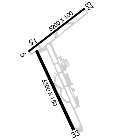
| Rwy | Rwy | |||||||
| 5200x100 | 5200' | 5200x100 | 5200' | |||||
| 6500x150 | 6500' | 109.10 - 151° | 6500x150 | 6500' | ||||
| Runway ID | Single Wheel | Double Wheel | Double Tandem Wheel | Dual Double Wheel |
| 05/23 | 70,000 | 90,000 | 140,000 | N/A |
| 15/33 | 100,000 | 145,000 | 260,000 | N/A |
| These numbers are Advisory and are not limits. The Airport Manager should have more accurate Weight Limits | ||||
 Airport Diagram might not be current. | |
| Facility Name: | LAKE CHARLES RGNL |
| City Name: | LAKE CHARLES |
| County: | CALCASIEU |
| State abbrev: | LA |
| State Name: | LOUISIANA |
| Ownership: | PUBLICLY OWNED |
| Use: | OPEN TO THE PUBLIC |
| Owner's Name: | CALCASIEU PARISH |
| Address: | PO BOX 5820 |
| LAKE CHARLES, LA 70607 | |
| Owner's Phone: | 337-477-6051 |
| Manager's Name: | HEATH ALLEN |
| Address: | PO DRAWER 5820 |
| LAKE CHARLES, LA 70607-5820 | |
| Phone: | 337-477-6051 |
| FAA Region: | SOUTHWEST |
| FAA Field Office: | LNM |

| Date | Sunrise | Sunset |
|---|---|---|
| 04/19/24 Friday | 6:41 | 19:43 |
| 04/20/24 Saturday | 6:40 | 19:44 |
| 04/21/24 Sunday | 6:39 | 19:45 |
| 04/22/24 Monday | 6:38 | 19:45 |
| 04/23/24 Tuesday | 6:37 | 19:46 |
| 04/24/24 Wednesday | 6:36 | 19:47 |
| 04/25/24 Thursday | 6:35 | 19:47 |
| 04/26/24 Friday | 6:34 | 19:48 |
| 04/27/24 Saturday | 6:33 | 19:48 |
| 04/28/24 Sunday | 6:32 | 19:49 |
| 04/29/24 Monday | 6:31 | 19:50 |
| 04/30/24 Tuesday | 6:30 | 19:50 |
| 05/01/24 Wednesday | 6:29 | 19:51 |
| 05/02/24 Thursday | 6:28 | 19:52 |
| Airport Attendance Schedule | 7 Days A Week 0500-2230 |
| Airport Status | OPERATIONAL (This Status can change at any time - please check NOTAMS) |
| Airport Lighting Schedule | WHEN ATCT CLSD ACTVT MALSR RWY 15; MALSF RWY 33; HIRL RWY 15/33; MIRL RWY 05/23 - CTAF. PAPI RWY 33 OPR CONSLY. |
| Airport Storage Available | Tie Downs, Hanger |
| Extra Services Available | Air Freight, Avionics, Charter, Flight Instruction, Aircraft Rental |
| Wind Indicator | YES - (lighted) |
| Control Tower | YES |
| CTAF Frequency | 120.700 |
| Unicom Frequency | 122.950 |
| Rotating Beacon Color | WG |
| Segmented Circle | YES |
| Landing Fee | NO |
| Airport Inspected | FEDERAL - performed by FAA AIRPORTS FIELD PERSONNEL |
| Inspection Date | 02/09/2024 |
| Type of Fuel Available | Grade 100LL, JET A-1 (icing inhibitor, freeze point -50C) |
| Airframe Repair Service | MAJOR |
| Power Plant Repair Service | MAJOR |
| Latitude | N3007.6 |
| Longitude | W09313.4 (ESTIMATED) |
| Arpt Elevation | 14ft (SURVEYED) |
| Magnetic Variation | 03E |
| 5 miles S | of LAKE CHARLES |
| Traffic Pattern Altitude | |
| Sectional Chart | HOUSTON |
| Operations (Reported) | Yearly | Avg. Daily |
|---|---|---|
| General Aviation Transient | 11099 | 30 |
| General Aviation Local | 4546 | 12 |
| Air Taxi | 6302 | 17 |
| Commerical | 1729 | 5 |
| Commuter | 0 | 0 |
| Military | 372 | 1 |
| Aircraft based on Field | |
|---|---|
| General Aviation Singles | 27 |
| General Aviation Multi | 7 |
| Jet Aircraft | 2 |
| General Aviation Helicopters | 6 |
| Military Aircraft | 0 |
| Gliders | 0 |
| Ultralights | 0 |
| FSS on field | NO |
| FSS tie-in | DE RIDDER |
| FSS Phone | 1-800-WX-BRIEF |
| Who issues Notams | LCH |
| Notam D service at airport | YES |
| ARTCC Name | HOUSTON |
| Airport Certification | AIRPORT RECEIVING SCHEDULED AIR CARRIER SERVICE FROM CARRIERS CERTIFICATED BY THE CIVIL AERONAUTICS BOARD |
| Aircraft Rescue & Firefighting Index | AIRPORT HAS A CERTIFICATE UNDER CFR PART 139 |
| Airport of Entry | No |
| Custom Landing Rights | YES |
| Joint Civil/Military | No |
| Military Landing rights | YES |
| NATIONAL PLAN OF INTEGRATED AIRPORT SYSTEMS (NPIAS) |
| GRANT AGREEMENTS UNDER FAAP/ADAP/AIP |
| ASSURANCES PURSUANT TO TITLE VI, CIVIL RIGHTS ACT OF 1964 |
| THIS AIRPORT HAS BEEN SURVEYED BY THE NATIONAL GEODETIC SURVEY. |
| ATCT BLIND SPOT ON TWY J. |
| BIRDS ON & INVOF ARPT. |
| FOR CD IF UNA TO CTC ON FSS FREQ, CTC HOUSTON ARTCC AT 281-230-5622. |
| RWY 15/3 3 SOUTH 900 FT GRVD. |
Airport Communications & Frequencies:
| |||||||||||||||||||||||||||||||||||||||
| Runway: 05 | Runway: 23 | ||
| Mag heading: | 49° | Mag heading: | 229° |
| Rwy Slope: | .09% Up | Rwy Slope: | -.09% Down |
| Approach: | Approach: | ||
| Pattern: | Left Traffic | Pattern: | Right Traffic |
| Markings: | NONPRECISION INSTRUMENT | Markings: | NONPRECISION INSTRUMENT |
| Marking Condition: | FAIR | Marking Condition: | FAIR |
| Arresting Dev: | Arresting Dev: | ||
| Lat & Long: | N3007.7 W09313.8 | Lat. & Long.: | N3008.2 W09313.0 |
| Elev: | 10.0 ft. MSL | Elev: | 14.5 ft. MSL |
| TCH: | 49 ft. AGL | TCH: | 47 ft. AGL |
| Visual Glide Path: | 3.00 degrees | Visual Glide Path: | 3.00 degrees |
| Displaced Threshold: | No | Displaced Threshold: | No |
| Touchdown Zone: | YES | Touchdown Zone: | YES |
| Touchdown Elev.: | 13.5 feet | Touchdown Elev.: | 14.6 feet |
| Visual Glide Slope: | 4-Light PAPI on LEFT side of Runway | Visual Glide Slope: | 4-BOX VASI ON LEFT SIDE OF RUNWAY |
| RVR Equipment: | RVR Equipment: | ||
| RVV Equipment: | NO | RVV Equipment: | NO |
| Approach Lights: | Approach Lights: | ||
| REIL: | YES | REIL: | YES |
| Centerline Lights: | NO | Centerline Lights: | NO |
| Touchdown lights: | NO | Touchdown lights: | NO |
| Runway Category: | Runway with a Non-precision Approach having visibility minimums greater than 3/4 mile | Runway Category: | Runway with a Non-precision Approach having visibility minimums greater than 3/4 mile |
| Declared Distances: | TORA:5200' TODA:5200' ASDA:5200' LDA:5200' | Declared Distances: | TORA:5200' TODA:5200' ASDA:5200' LDA:5200' |
| Obstructions: | TREE | Obstructions: | |
| Marked: | NOT Marked/Lighted | Marked: | |
| Clearance slope: | 21:1 | Clearance slope: | 50:1 |
| Obstruction height: | 65 feet AGL | Obstruction height: | |
| Dist. from runway: | 1620 feet | Dist. from runway: | |
| Centerline offset: | 455 right of centerline | Centerline offset: | |
| Comments: | Comments: |
| Runway: 15 | Runway: 33 | ||
| Mag heading: | 152° | Mag heading: | 332° |
| Rwy Slope: | -.02% Down | Rwy Slope: | .02% Up |
| Approach: | ILS/DME | Approach: | |
| Pattern: | Right Traffic | Pattern: | Left Traffic |
| Markings: | PRECISION INSTRUMENT | Markings: | PRECISION INSTRUMENT |
| Marking Condition: | GOOD | Marking Condition: | GOOD |
| Arresting Dev: | Arresting Dev: | ||
| Lat & Long: | N3007.7 W09313.7 | Lat. & Long.: | N3006.8 W09313.1 |
| Elev: | 11.4 ft. MSL | Elev: | 10.3 ft. MSL |
| TCH: | 70 ft. AGL | TCH: | 54 ft. AGL |
| Visual Glide Path: | 3.00 degrees | Visual Glide Path: | 3.00 degrees |
| Displaced Threshold: | No | Displaced Threshold: | No |
| Touchdown Zone: | YES | Touchdown Zone: | YES |
| Touchdown Elev.: | 11.5 feet | Touchdown Elev.: | 11.0 feet |
| Visual Glide Slope: | 4-Light PAPI on LEFT side of Runway | Visual Glide Slope: | 4-Light PAPI on RIGHT side of Runway |
| RVR Equipment: | TOUCHDOWN-MIDFIELD | RVR Equipment: | MIDFIELD |
| RVV Equipment: | YES | RVV Equipment: | NO |
| Approach Lights: | MALSR - 1,400 foot medium intensity approach lighting system with runway alignment indicator lights | Approach Lights: | MALSF - 1,400 foot medium intensity approach lighting system with sequenced flashers |
| REIL: | NO | REIL: | NO |
| Centerline Lights: | NO | Centerline Lights: | NO |
| Touchdown lights: | NO | Touchdown lights: | NO |
| Runway Category: | Precision Instrument Runway | Runway Category: | D |
| Declared Distances: | TORA:6500' TODA:6500' ASDA:6500' LDA:6500' | Declared Distances: | TORA:6500' TODA:6500' ASDA:6500' LDA:6500' |
| Obstructions: | POLE | Obstructions: | |
| Marked: | NOT Marked/Lighted | Marked: | |
| Clearance slope: | 46:1 | Clearance slope: | 50:1 |
| Obstruction height: | 28 feet AGL | Obstruction height: | |
| Dist. from runway: | 1412 feet | Dist. from runway: | |
| Centerline offset: | 421 left of centerline | Centerline offset: | |
| Comments: | Comments: |
Thanks for using FltPlan.com
all rights reserved © 1999-2024 by Flight Plan LLC