
| CARTER PULASKI WI |
| |
| Lat: N 4438.5 Long: W 08812.9 Elev: 783 Var: +02 Longest Runway: 2955 | ||
| CTAF: 122.9 | ||
| ||||||||||||||||||||||||||||||||||||||||||||
| ||||||||||||||||||||||||||||||||||||||||||||
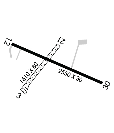
| Rwy | Rwy | |||||||
| 1281x80 | 1281' | 1281x80 | 1281' | |||||
| 2955x38 | 2580' | 2955x38 | 2575' | |||||
| Runway ID | Single Wheel | Double Wheel | Double Tandem Wheel | Dual Double Wheel |
| 04/22 | N/A | N/A | N/A | N/A |
| 12/30 | N/A | N/A | N/A | N/A |
| These numbers are Advisory and are not limits. The Airport Manager should have more accurate Weight Limits | ||||
| FltPlan does not have IFR approach charts available for K92C. |
 Airport Diagram might not be current. | |
| Facility Name: | CARTER |
| City Name: | PULASKI |
| County: | BROWN |
| State abbrev: | WI |
| State Name: | WISCONSIN |
| Ownership: | PRIVATELY OWNED |
| Use: | OPEN TO THE PUBLIC |
| Owner's Name: | PLANE AND SIMPLE LLP |
| Address: | 5207 FRONTIER RD |
| DENMARK, WI 54208 | |
| Owner's Phone: | 920-822-3644 |
| Manager's Name: | BLUE SKIES AVIATION |
| Address: | 3736 STATE ROAD 32; EMAIL ADDRESS: TEKO299@AOL.COM (ALL LOWER CASEE) |
| PULASKI, WI 54162 | |
| Phone: | 920-822-3644 |
| FAA Region: | GREAT LAKES |
| FAA Field Office: | CHI |
| Date | Sunrise | Sunset |
|---|---|---|
| 06/29/25 Sunday | 5:10 | 20:42 |
| 06/30/25 Monday | 5:11 | 20:42 |
| 07/01/25 Tuesday | 5:11 | 20:42 |
| 07/02/25 Wednesday | 5:12 | 20:42 |
| 07/03/25 Thursday | 5:12 | 20:41 |
| 07/04/25 Friday | 5:13 | 20:41 |
| 07/05/25 Saturday | 5:14 | 20:41 |
| 07/06/25 Sunday | 5:14 | 20:41 |
| 07/07/25 Monday | 5:15 | 20:40 |
| 07/08/25 Tuesday | 5:16 | 20:40 |
| 07/09/25 Wednesday | 5:17 | 20:39 |
| 07/10/25 Thursday | 5:17 | 20:39 |
| 07/11/25 Friday | 5:18 | 20:38 |
| 07/12/25 Saturday | 5:19 | 20:38 |
| Airport Attendance Schedule | 7 Days A Week DALGT |
| Airport Status | OPERATIONAL (This Status can change at any time - please check NOTAMS) |
| Airport Lighting Schedule | ACTVT NSTD LIRL RY 12/30, 3 CLICKS ON 5 CLICKS OFF - CTAF.; ACTVT ROTG BCN , 3 CLICKS ON 5 CLICKS OFF - CTAF. |
| Airport Storage Available | Tie Downs, Hanger |
| Extra Services Available | Flight Instruction, Parachute Jumping |
| Wind Indicator | YES - (lighted) |
| Control Tower | NO |
| CTAF Frequency | 122.900 |
| Unicom Frequency | |
| Rotating Beacon Color | WG |
| Segmented Circle | YES |
| Landing Fee | NO |
| Airport Inspected | STATE - performed by STATE AERONAUTICAL PERSONNEL |
| Inspection Date | 08/04/2023 |
| Type of Fuel Available | Grade 100LLUL94 |
| Airframe Repair Service | MINOR |
| Power Plant Repair Service | MINOR |
| Latitude | N4438.5 |
| Longitude | W08812.9 (ESTIMATED) |
| Arpt Elevation | 783ft (ESTIMATED) |
| Magnetic Variation | 02W |
| 2 miles SSE | of PULASKI |
| Traffic Pattern Altitude | 800 |
| Sectional Chart | GREEN BAY |
| Operations (Reported) | Yearly | Avg. Daily |
|---|---|---|
| General Aviation Transient | 0 | 0 |
| General Aviation Local | 0 | 0 |
| Air Taxi | 0 | 0 |
| Commerical | 0 | 0 |
| Commuter | 0 | 0 |
| Military | 0 | 0 |
| Aircraft based on Field | |
|---|---|
| General Aviation Singles | 0 |
| General Aviation Multi | 0 |
| Jet Aircraft | 0 |
| General Aviation Helicopters | 0 |
| Military Aircraft | 0 |
| Gliders | 0 |
| Ultralights | 0 |
| FSS on field | NO |
| FSS tie-in | GREEN BAY |
| FSS Phone | 1-800-WX-BRIEF |
| Who issues Notams | GRB |
| Notam D service at airport | YES |
| ARTCC Name | MINNEAPOLIS |
| Airport Certification | |
| Aircraft Rescue & Firefighting Index | None |
| Airport of Entry | No |
| Custom Landing Rights | No |
| Joint Civil/Military | No |
| Military Landing rights | No |
| PAJA ON ARPT. |
| ULTRA-LIGHT FLYING ON & INVOF ARPT. |
| LIMITED LINE-OF-SIGHT BETWEEN RWY 04 & 12; RWY 04 & 30. |
| FOR CD CTC GREEN BAY APCH AT 920-431-5741, WHEN GREEN BAY APCH CLSD, FOR CD CTC MINNEAPOLIS ARTCC AT 651-463-5588. |
| RWY 12/3 0 RY 12/30 NSTD LIRL SPACED EVERY 300 FT. RY LIGHTED 2205 FT. |
Airport Communications & Frequencies:
| |||||||||||||||
| Runway: 04 | Runway: 22 | ||
| Mag heading: | N/A | Mag heading: | N/A |
| Rwy Slope: | .23% Up | Rwy Slope: | -.23% Down |
| Approach: | Approach: | ||
| Pattern: | Left Traffic | Pattern: | Left Traffic |
| Markings: | Markings: | ||
| Marking Condition: | Marking Condition: | ||
| Arresting Dev: | Arresting Dev: | ||
| Lat & Long: | N4438.4 W08813.1 | Lat. & Long.: | N4438.6 W08812.9 |
| Elev: | 774.0 ft. MSL | Elev: | 777.0 ft. MSL |
| TCH: | TCH: | ||
| Visual Glide Path: | Visual Glide Path: | ||
| Displaced Threshold: | No | Displaced Threshold: | No |
| Touchdown Zone: | YES | Touchdown Zone: | YES |
| Touchdown Elev.: | 777.0 feet | Touchdown Elev.: | 777.0 feet |
| Visual Glide Slope: | Visual Glide Slope: | ||
| RVR Equipment: | RVR Equipment: | ||
| RVV Equipment: | NO | RVV Equipment: | NO |
| Approach Lights: | Approach Lights: | ||
| REIL: | NO | REIL: | NO |
| Centerline Lights: | NO | Centerline Lights: | NO |
| Touchdown lights: | NO | Touchdown lights: | NO |
| Runway Category: | Runway with a Visual Approach | Runway Category: | Runway with a Visual Approach |
| Declared Distances: | Declared Distances: | ||
| Obstructions: | TREE | Obstructions: | TREES |
| Marked: | NOT Marked/Lighted | Marked: | NOT Marked/Lighted |
| Clearance slope: | 1:1; CTLN OBSTN EXCEEDS A 45 DEG SLP. | Clearance slope: | |
| Obstruction height: | 50 feet AGL | Obstruction height: | 25 feet AGL |
| Dist. from runway: | 50 feet | Dist. from runway: | 0 feet |
| Centerline offset: | 80 right of centerline | Centerline offset: | 95 feet right of centerline |
| Comments: | Comments: |
| Runway: 12 | Runway: 30 | ||
| Mag heading: | 116° | Mag heading: | 296° |
| Rwy Slope: | -.28% Down | Rwy Slope: | .28% Up |
| Approach: | Approach: | ||
| Pattern: | Left Traffic | Pattern: | Left Traffic |
| Markings: | BASIC | Markings: | BASIC |
| Marking Condition: | GOOD | Marking Condition: | GOOD |
| Arresting Dev: | Arresting Dev: | ||
| Lat & Long: | N4438.6 W08813.2 | Lat. & Long.: | N4438.4 W08812.6 |
| Elev: | 782.2 ft. MSL | Elev: | 773.8 ft. MSL |
| TCH: | TCH: | ||
| Visual Glide Path: | Visual Glide Path: | ||
| Displaced Threshold: | 375 feet | Displaced Threshold: | 380 feet |
| Touchdown Zone: | YES | Touchdown Zone: | YES |
| Touchdown Elev.: | 781.4 feet | Touchdown Elev.: | 782.2 feet |
| Visual Glide Slope: | Visual Glide Slope: | ||
| RVR Equipment: | RVR Equipment: | ||
| RVV Equipment: | NO | RVV Equipment: | NO |
| Approach Lights: | Approach Lights: | ||
| REIL: | NO | REIL: | NO |
| Centerline Lights: | NO | Centerline Lights: | NO |
| Touchdown lights: | NO | Touchdown lights: | NO |
| Runway Category: | Runway with a Visual Approach | Runway Category: | Runway with a Visual Approach |
| Declared Distances: | Declared Distances: | ||
| Obstructions: | TREES | Obstructions: | TREES |
| Marked: | NOT Marked/Lighted | Marked: | NOT Marked/Lighted |
| Clearance slope: | APCH RATIO 15:1 TO DSPLCD THR; 45 FT TREES 670 FT FM DSPLCD THR, 80 FT R. | Clearance slope: | APCH RATIO 10:1 TO DSPLCD THR; 60 FT TREES 380 FT FM DSPLCD THR, 125 FT L. |
| Obstruction height: | 35 feet AGL | Obstruction height: | 60 feet AGL |
| Dist. from runway: | 200 feet | Dist. from runway: | 200 feet |
| Centerline offset: | 35 right of centerline | Centerline offset: | 125 feet left of centerline |
| Comments: | 30 FT TREES 170 FT FM RWY END, 25 FT R; RD 0-70 FT FM RWY END, 60-0 FT L. | Comments: | 50 FT TREES 0-200 FT FM RWY END, 100 FT L. |
Thanks for using FltPlan.com
all rights reserved © 1999-2025 by Flight Plan LLC
