| BOUNDARY COUNTY BONNERS FERRY ID |
| |
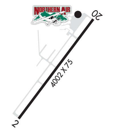
| Lat: N 4843.6 Long: W 11617.7 Elev: 2337 Var: -16 Longest Runway: 4002 | ||
| AWOS: 132.57 CTAF: 123.0 | ||
| ||||||||||||||||||||||||||||||||||||||||||||||||||||||||||||||||||||
| ||||||||||||||||||||||||||||||||||||||||||||||||||||||||||||||||||||
| ||||||||||||||||||||||||||||||||||||||||||||||||||||||||||||||||||||
| Rwy | Rwy | |||||||
| 4002x75 | 4002' | 4002x75 | 4002' | |||||
| Runway ID | Single Wheel | Double Wheel | Double Tandem Wheel | Dual Double Wheel |
| 02/20 | 25,000 | N/A | N/A | N/A |
| These numbers are Advisory and are not limits. The Airport Manager should have more accurate Weight Limits | ||||
 Airport Diagram might not be current. | |
| Facility Name: | BOUNDARY COUNTY |
| City Name: | BONNERS FERRY |
| County: | BOUNDARY |
| State abbrev: | ID |
| State Name: | IDAHO |
| Ownership: | PUBLICLY OWNED |
| Use: | OPEN TO THE PUBLIC |
| Owner's Name: | BOUNDARY COUNTY |
| Address: | PO BOX 419 |
| BONNERS FERRY, ID 83805 | |
| Owner's Phone: | 208-267-7723 |
| Manager's Name: | DAVE PARKER |
| Address: | 64602 HIGHWAY 2 |
| BONNERS FERRY, ID 83805 | |
| Phone: | 208-267-3711 |
| FAA Region: | NORTHWEST MOUNTAIN |
| FAA Field Office: | HLN |
| Date | Sunrise | Sunset |
|---|---|---|
| 04/18/24 Thursday | 5:47 | 19:43 |
| 04/19/24 Friday | 5:45 | 19:44 |
| 04/20/24 Saturday | 5:43 | 19:45 |
| 04/21/24 Sunday | 5:41 | 19:47 |
| 04/22/24 Monday | 5:39 | 19:48 |
| 04/23/24 Tuesday | 5:38 | 19:50 |
| 04/24/24 Wednesday | 5:36 | 19:51 |
| 04/25/24 Thursday | 5:34 | 19:53 |
| 04/26/24 Friday | 5:32 | 19:54 |
| 04/27/24 Saturday | 5:30 | 19:56 |
| 04/28/24 Sunday | 5:29 | 19:57 |
| 04/29/24 Monday | 5:27 | 19:59 |
| 04/30/24 Tuesday | 5:25 | 20:00 |
| 05/01/24 Wednesday | 5:24 | 20:02 |
| Airport Attendance Schedule | MON-FRI 0800-1700, SAT 0800-1600 |
| Airport Status | OPERATIONAL (This Status can change at any time - please check NOTAMS) |
| Airport Lighting Schedule | ACTVT MIRL RY 02/20 CTAF; VASI RY 20 OPERATES CONTINUOUSLY. |
| Airport Storage Available | Tie Downs, Hanger |
| Extra Services Available | Charter, Flight Instruction, Aircraft Rental, Aircraft Sales |
| Wind Indicator | YES - (lighted) |
| Control Tower | NO |
| CTAF Frequency | 123.000 |
| Unicom Frequency | 123.000 |
| Rotating Beacon Color | WG |
| Segmented Circle | YES |
| Landing Fee | NO |
| Airport Inspected | STATE - performed by STATE AERONAUTICAL PERSONNEL |
| Inspection Date | 09/02/2021 |
| Type of Fuel Available | Grade 100LL, JET A (freeze point -40C) |
| Airframe Repair Service | MAJOR |
| Power Plant Repair Service | MINOR |
| Latitude | N4843.6 |
| Longitude | W11617.7 (ESTIMATED) |
| Arpt Elevation | 2337ft (SURVEYED) |
| Magnetic Variation | 16E |
| 2 miles NE | of BONNERS FERRY |
| Traffic Pattern Altitude | |
| Sectional Chart | GREAT FALLS |
| Operations (Reported) | Yearly | Avg. Daily |
|---|---|---|
| General Aviation Transient | 12500 | 34 |
| General Aviation Local | 5800 | 16 |
| Air Taxi | 600 | 2 |
| Commerical | 0 | 0 |
| Commuter | 0 | 0 |
| Military | 125 | 0 |
| Aircraft based on Field | |
|---|---|
| General Aviation Singles | 71 |
| General Aviation Multi | 3 |
| Jet Aircraft | 1 |
| General Aviation Helicopters | 4 |
| Military Aircraft | 0 |
| Gliders | 2 |
| Ultralights | 0 |
| FSS on field | NO |
| FSS tie-in | BOISE |
| FSS Phone | 1-800-WX-BRIEF |
| Who issues Notams | BOI |
| Notam D service at airport | YES |
| ARTCC Name | SEATTLE |
| Airport Certification | |
| Aircraft Rescue & Firefighting Index | None |
| Airport of Entry | No |
| Custom Landing Rights | No |
| Joint Civil/Military | No |
| Military Landing rights | YES |
| NATIONAL PLAN OF INTEGRATED AIRPORT SYSTEMS (NPIAS) |
| GRANT AGREEMENTS UNDER FAAP/ADAP/AIP |
| ASSURANCES PURSUANT TO TITLE VI, CIVIL RIGHTS ACT OF 1964 |
| COLD TEMPERATURE AIRPORT. ALTITUDE CORRECTION REQUIRED AT OR BELOW -7C. |
| FOR CD CTC SEATTLE ARTCC AT 253-351-3694. |
Airport Communications & Frequencies:
| |||||||||
| Runway: 02 | Runway: 20 | ||
| Mag heading: | 22° | Mag heading: | 202° |
| Rwy Slope: | .53% Up | Rwy Slope: | -.53% Down |
| Approach: | Approach: | ||
| Pattern: | Left Traffic | Pattern: | Left Traffic |
| Markings: | NONPRECISION INSTRUMENT | Markings: | NONPRECISION INSTRUMENT |
| Marking Condition: | GOOD | Marking Condition: | GOOD |
| Arresting Dev: | Arresting Dev: | ||
| Lat & Long: | N4843.3 W11618.0 | Lat. & Long.: | N4843.8 W11617.4 |
| Elev: | 2315.5 ft. MSL | Elev: | 2336.9 ft. MSL |
| TCH: | 37 ft. AGL | TCH: | |
| Visual Glide Path: | 3.50 degrees | Visual Glide Path: | |
| Displaced Threshold: | No | Displaced Threshold: | No |
| Touchdown Zone: | YES | Touchdown Zone: | YES |
| Touchdown Elev.: | 2315.7 feet | Touchdown Elev.: | 2336.9 feet |
| Visual Glide Slope: | 2-Light PAPI on LEFT side of Runway | Visual Glide Slope: | |
| RVR Equipment: | RVR Equipment: | ||
| RVV Equipment: | NO | RVV Equipment: | NO |
| Approach Lights: | Approach Lights: | ||
| REIL: | NO | REIL: | NO |
| Centerline Lights: | NO | Centerline Lights: | NO |
| Touchdown lights: | NO | Touchdown lights: | NO |
| Runway Category: | Runway with a Non-precision Approach | Runway Category: | Runway with a Visual Approach |
| Declared Distances: | Declared Distances: | ||
| Obstructions: | RWY 02 +85 FT TREES AT 90 FT, 400 FT L. | Obstructions: | FENCE; +85 FT TREES AT 1200 FT 300 FT L; +75 FT TREES AT 1600 FT ON CNTRLN. |
| Marked: | NOT Marked/Lighted | Marked: | NOT Marked/Lighted |
| Clearance slope: | 20:1 | Clearance slope: | |
| Obstruction height: | 0 feet AGL | Obstruction height: | 7 feet AGL |
| Dist. from runway: | 0 feet | Dist. from runway: | 200 feet |
| Centerline offset: | Centerline offset: | 240 feet right of centerline | |
| Comments: | Comments: |
Thanks for using FltPlan.com
all rights reserved © 1999-2024 by Flight Plan LLC