KIWA

PHOENIX-MESA GATEWAY
PHOENIX
AZ
Time Zone: Pacific
Lat: N 3318.5
Long: W 11139.3
Elev: 1384
Var: -13
Longest Runway: 10401
Clr Del: 135.05
Dept. ATIS: 133.5
Arr. ATIS: 133.5
AWOS: 133.5
Ground: 128.25
Tower: 120.6

FBO & Flight Services info for KIWA

FBOs: Update your Fuel Prices

  click here  
Phoenix-Mesa Gateway Airport is a prime alternative for your flight operations. Benefits to using KIWA include: 3 expansive runways, easy access to the Loop 202 Freeway, and 24-hour/7 day a week service available from the airport-owned FBO - Gateway Aviation Services. We offer competitive fuel prices. Call customer service any time day or night at 480-988-7700. We look forward to serving you!
Ph: 480-988-7700 Fax: 480-988-7706 Freq: 129.87WebsiteE-Mail
                                   
Service
Jet
100LL
SAF
MoGas
Fuel Avail: 24/7
Full6.207.00    Last Update: 04/30/2024 10:41

Self        
Misc. Info: Address: 5803 SOUTH SOSSAMAN ROAD SUITE 116,   MESA, AZ 85212

AWOSPh: 480-988-9428
-
Freq: 133.5  
If you are an FBO, call 1-203-262-1700 to update your info or email: FltPlan.Advertising@garmin.com
Advertise your FBO on FltPlan.com


Runway & Approach Info for KIWA
Rwy
Length
Land Dist**
Approach*
  Rwy
Length
Land Dist**
Approach*
12C
10201x150  10201'          
 
  
30C
  10201x150  10201'          
LOC/GS
 110.15 - 302°  
12L
9300x150  9300'          
 
  
30R
  9300x150  9300'          
 
12R
10401x150  10401'          
 
  
30L
  10401x150  10401'          
 
 * only ILS, LOC, LDA, and SDF approaches to a specific runway are shown
** For any Declared Landing Distance Available, please see A/FD or Approach plates
Runway Weight Capability (lbs.) Help
Runway IDSingle WheelDouble WheelDouble Tandem WheelDual Double Wheel
12C/30C55,00095,000185,000550,000
12L/30R75,000210,000590,000850,000
12R/30L55,00095,000185,000550,000
These numbers are Advisory and are not limits.   The Airport Manager should have more accurate Weight Limits
Approach Charts
Approaches    
Current Weather/Notams
Customs Information Send updates to Support@FltPlan.com
Phone 480-279-2928
Fax 480-279-2823

Comments Mon-Fri 1100-1900 *Maximum passengers per flight: 15 Approved OFE required. Prior arrangements and approval required.
Database effective 05/16/2024
Airport Diagram of KIWA
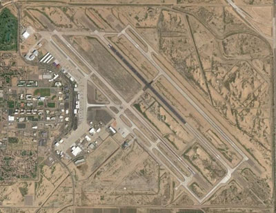
Airport Diagram might not be current.

Facility Name: PHOENIX-MESA GATEWAY
City Name: PHOENIX
County: MARICOPA
State abbrev: AZ
State Name: ARIZONA
   
Ownership: PUBLICLY OWNED
Use: OPEN TO THE PUBLIC
Owner's Name: PHX MESA GATEWAY AIRPORT AUTHORITY
Address: 5835 S. SOSSAMAN RD
 MESA, AZ 85212-0919
Owner's Phone: 480-988-7570
  
Manager's Name: J. BRIAN O'NEILL
Address: PHX-MESA GATEWAY AIRPORT AUTHORITY, 5835 S. SOSSAMAN ROAD
 MESA, AZ 85212-0919
Phone: 480-988-7708
   
FAA Region: WESTERN-PACIFIC
FAA Field Office: PHX
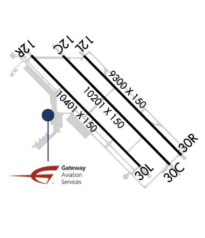

Sunrise / Sunset times for PHOENIX-MESA GATEWAY

DateSunriseSunset
05/02/24 Thursday5:3719:11
05/03/24 Friday5:3619:11
05/04/24 Saturday5:3519:12
05/05/24 Sunday5:3419:13
05/06/24 Monday5:3319:14
05/07/24 Tuesday5:3219:14
05/08/24 Wednesday5:3119:15
05/09/24 Thursday5:3119:16
05/10/24 Friday5:3019:17
05/11/24 Saturday5:2919:17
05/12/24 Sunday5:2819:18
05/13/24 Monday5:2719:19
05/14/24 Tuesday5:2719:20
05/15/24 Wednesday5:2619:20

Airport Facilities

Airport Attendance ScheduleCONTINUOUS
Airport Status OPERATIONAL (This Status can change at any time - please check NOTAMS)
Airport Lighting ScheduleWHEN ATCT CLSD LGTS ON CONSLY.
Airport Storage AvailableTie Downs, Hanger
Extra Services AvailableAir Ambulance, Avionics, Cargo Handling, Charter, Flight Instruction, Aircraft Rental
Wind IndicatorYES - (unlit)
Control TowerYES
CTAF Frequency120.600
Unicom Frequency
Rotating Beacon ColorWG
Segmented CircleYES
Landing FeeYES; US GOV OWNED, NON REVENUE & FLT TRNG UP TO 12500 LB LNDG FEE NA.

Airport Inspection Data

Airport InspectedFEDERAL - performed by FAA AIRPORTS FIELD PERSONNEL
Inspection Date02/08/2024

Airport Services

Type of Fuel AvailableGrade 100LL, JET A (freeze point -40C)
Airframe Repair ServiceMINOR
Power Plant Repair ServiceMAJOR

Geographic Data

LatitudeN3318.5
LongitudeW11139.3 (ESTIMATED)
Arpt Elevation1384ft (SURVEYED)
Magnetic Variation13E
20 miles SEof PHOENIX
Traffic Pattern Altitude1218; TPA FIXED WING 1218 FT AGL, JET 1718 FT AGL, ROTORCRAFT 718 FT AGL.
Sectional ChartPHOENIX

Aircraft Data

Operations (Reported)YearlyAvg. Daily
General Aviation Transient 2868679
General Aviation Local 153059419
Air Taxi 54405149
Commerical 1196133
Commuter 00
Military 30818
Aircraft based on Field
General Aviation Singles 20
General Aviation Multi 0
Jet Aircraft 33
General Aviation Helicopters 15
Military Aircraft 0
Gliders 0
Ultralights 0

FAA Services

FSS on field NO
FSS tie-in PRESCOTT
FSS Phone 1-800-WX-BRIEF
Who issues Notams IWA
Notam D service at airport YES
ARTCC Name ALBUQUERQUE

Federal Status

Airport CertificationAIRPORT RECEIVING SCHEDULED AIR CARRIER SERVICE FROM CARRIERS CERTIFICATED BY THE CIVIL AERONAUTICS BOARD
Aircraft Rescue & Firefighting IndexAIRPORT HAS A CERTIFICATE UNDER CFR PART 139
Airport of EntryNo
Custom Landing RightsNo; US CUSTOMS USER FEE ARPT.
Joint Civil/MilitaryNo
Military Landing rightsYES

Federal Agreements

NATIONAL PLAN OF INTEGRATED AIRPORT SYSTEMS (NPIAS)

Remarks

NOISE ABATEMENT PROC IN EFCT; AVOID LOW OVR FLT OF NOISE SENSITIVE AREAS; INFO - 480-988-7637.
TWY Y RSTD TO WINGSPAN LESS THAN 79 FT.
7 FT FENCE S PORTION OF MIDDLE RAMP.
LRG/HVY INBOARD ENGINE TAX ONLY.
TWY T AVBL TO WINGSPAN BTN 119-170 FT WITH WING WALKERS FM TWY W SOUTH OF TWY V.
NON EMERG AV-8 MODEL OPS LMTD TO RWY 12L/30R.
24 HR PPR FOR UNSKED ACR GTR THAN 30 PAX SEATS - ARPT OPS.
FOR CD WHEN ATCT CLSD, CTC PHOENIX APCH AT 602-306-2565.
FUEL AVBL H24 - 480-988-7700 OR 129.875.
WILDLIFE INVOF ARPT.
RWY 30R SPORT FIELD LGTG E OF APCH.
Airport Communications & Frequencies:
ATIS Frequencies:   Hours(local) of Operation: 0500-0000 (MST)
133.5
270.275
GATEWAY Tower Frequencies:   Hours(local) of operation: 0500-2400   
120.6
289.4
GATEWAY Ground Frequencies:
128.25
275.8
Clearance Delivery Frequencies:
135.05
Emergency Frequencies:
121.5
243.0
CTAF Frequency:
120.600
Remarks
  • ATCT OPERATED BY SERCO MGT SERVICES.
  • PHOENIX Primary Approach Frequencies:  
    124.9
    353.8
    PHOENIX Primary Departure Frequencies:  
    124.9
    353.8
    Runway Identifications
    Runway Identification: 12C/30C
    Length: 10201 ft
    Width: 150 ft
    Surface: CONCRETE ASPHALT-GOOD CONDITION
    Edge lights: High Intensity

    Treatment: NONE
    Weight: PCN 71 /R/D/W/T

     Runway: 12C   Runway: 30C
    Mag heading: 123°Mag heading: 303°
    Rwy Slope: .32% UpRwy Slope: -.32% Down
    Approach: Approach: LOC/GS
    Pattern: Left TrafficPattern: Left Traffic
    Markings: PRECISION INSTRUMENTMarkings: PRECISION INSTRUMENT
    Marking Condition: GOODMarking Condition: GOOD
    Arresting Dev: MA-1AArresting Dev: MA-1A
    Lat & Long: N3319.1  W11140.0Lat. & Long.: N3317.9  W11138.6
    Elev: 1347.7 ft. MSLElev: 1380.5 ft. MSL
    TCH: 50 ft. AGLTCH: 49 ft. AGL
    Visual Glide Path: 3.00 degreesVisual Glide Path: 3.00 degrees
    Displaced Threshold: NoDisplaced Threshold: No
    Touchdown Zone: YESTouchdown Zone: YES
    Touchdown Elev.: 1358.5 feetTouchdown Elev.: 1380.5 feet
    Visual Glide Slope: 4-Light PAPI on LEFT side of RunwayVisual Glide Slope: 4-Light PAPI on LEFT side of Runway
    RVR Equipment: RVR Equipment:
    RVV Equipment: NORVV Equipment: NO
    Approach Lights: Approach Lights:
    REIL: NOREIL: NO
    Centerline Lights: NOCenterline Lights: NO
    Touchdown lights: NOTouchdown lights: NO
    Runway Category: Runway with a Non-precision Approach having visibility minimums greater than 3/4 mileRunway Category: Precision Instrument Runway
    Declared Distances: TORA:10201' TODA:10201' ASDA:10201' LDA:10201'Declared Distances: TORA:10201' TODA:10201' ASDA:10201' LDA:10201'
    Runway Identification: 12L/30R
    Length: 9300 ft
    Width: 150 ft
    Surface: CONCRETE-GOOD CONDITION
    Edge lights: High Intensity

    Treatment: NONE
    Weight: PCN 88 /R/C/W/T

     Runway: 12L   Runway: 30R
    Mag heading: 123°Mag heading: 303°
    Rwy Slope: .30% UpRwy Slope: -.30% Down
    Approach: Approach:
    Pattern: Left TrafficPattern: Right Traffic
    Markings: PRECISION INSTRUMENTMarkings: PRECISION INSTRUMENT
    Marking Condition: GOODMarking Condition: GOOD
    Arresting Dev: MA-1AArresting Dev: MA-1A
    Lat & Long: N3319.1  W11139.7Lat. & Long.: N3318.0  W11138.4
    Elev: 1356.3 ft. MSLElev: 1384.1 ft. MSL
    TCH: 74 ft. AGLTCH: 75 ft. AGL
    Visual Glide Path: 3.00 degreesVisual Glide Path: 3.00 degrees
    Displaced Threshold: NoDisplaced Threshold: No
    Touchdown Zone: YESTouchdown Zone: YES
    Touchdown Elev.: 1365.0 feetTouchdown Elev.: 1384.1 feet
    Visual Glide Slope: 4-Light PAPI on LEFT side of RunwayVisual Glide Slope: 4-Light PAPI on LEFT side of Runway
    RVR Equipment: RVR Equipment:
    RVV Equipment: NORVV Equipment: NO
    Approach Lights: Approach Lights:
    REIL: YESREIL: YES
    Centerline Lights: NOCenterline Lights: NO
    Touchdown lights: NOTouchdown lights: NO
    Runway Category: Runway with a Visual ApproachRunway Category: Runway with a Visual Approach
    Declared Distances: TORA:9300' TODA:9300' ASDA:9300' LDA:9300'Declared Distances: TORA:9300' TODA:9300' ASDA:9300' LDA:9300'
    Runway Identification: 12R/30L
    Length: 10401 ft
    Width: 150 ft
    Surface: CONCRETE-GOOD CONDITION
    Edge lights: Medium Intensity

    Treatment: NONE
    Weight: PCN 62 /R/C/W/T

     Runway: 12R   Runway: 30L
    Mag heading: 123°Mag heading: 303°
    Rwy Slope: .32% UpRwy Slope: -.32% Down
    Approach: Approach:
    Pattern: Right TrafficPattern: Left Traffic
    Markings: PRECISION INSTRUMENTMarkings: PRECISION INSTRUMENT
    Marking Condition: GOODMarking Condition: GOOD
    Arresting Dev: MA-1AArresting Dev: MA-1A
    Lat & Long: N3319.1  W11140.4Lat. & Long.: N3317.8  W11138.9
    Elev: 1341.2 ft. MSLElev: 1374.2 ft. MSL
    TCH: 60 ft. AGLTCH: 60 ft. AGL
    Visual Glide Path: 3.00 degreesVisual Glide Path: 3.00 degrees
    Displaced Threshold: NoDisplaced Threshold: No
    Touchdown Zone: YESTouchdown Zone: YES
    Touchdown Elev.: 1348.8 feetTouchdown Elev.: 1374.2 feet
    Visual Glide Slope: 4-Light PAPI on LEFT side of RunwayVisual Glide Slope: 4-Light PAPI on LEFT side of Runway
    RVR Equipment: RVR Equipment:
    RVV Equipment: NORVV Equipment: NO
    Approach Lights: Approach Lights:
    REIL: NOREIL: NO
    Centerline Lights: NOCenterline Lights: NO
    Touchdown lights: NOTouchdown lights: NO
    Runway Category: Runway with a Non-precision Approach having visibility minimums greater than 3/4 mileRunway Category: Runway with a Non-precision Approach having visibility minimums greater than 3/4 mile
    Declared Distances: TORA:10401' TODA:10401' ASDA:10401' LDA:10401'Declared Distances: TORA:10401' TODA:10401' ASDA:10401' LDA:10401'
    C:114/P: