
| HILLMAN HILLMAN MI |
| |
| Lat: N 4505.0 Long: W 08356.3 Elev: 852 Var: +06 Longest Runway: 3400 | ||
| CTAF: 122.9 | ||
| ||||||||||||||||||||||||||||||||
| ||||||||||||||||||||||||||||||||
| Rwy | Rwy | |||||||
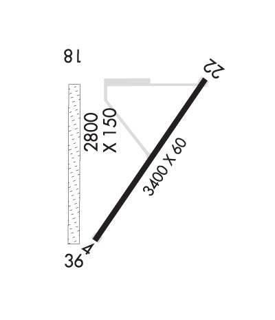
| 3400x60 | 3400' | 3400x60 | 2640' | |||||
| 2900x100 | 1500' | 2900x100 | 2900' | |||||
| Runway ID | Single Wheel | Double Wheel | Double Tandem Wheel | Dual Double Wheel |
| 04/22 | N/A | N/A | N/A | N/A |
| 18/36 | N/A | N/A | N/A | N/A |
| These numbers are Advisory and are not limits. The Airport Manager should have more accurate Weight Limits | ||||
| FltPlan does not have IFR approach charts available for KY95. |
 Airport Diagram might not be current. | |
| Facility Name: | HILLMAN |
| City Name: | HILLMAN |
| County: | MONTMORENCY |
| State abbrev: | MI |
| State Name: | MICHIGAN |
| Ownership: | PUBLICLY OWNED |
| Use: | OPEN TO THE PUBLIC |
| Owner's Name: | VILLAGE OF HILLMAN |
| Address: | PO BOX 96 |
| HILLMAN, MI 49746-0096 | |
| Owner's Phone: | 989-742-4751 |
| Manager's Name: | MARK MELLINGEN |
| Address: | 1194 HAHN TRL |
| HILLMAN, MI 49746 | |
| Phone: | 989-306-4659; RES 989-742-2893. |
| FAA Region: | GREAT LAKES |
| FAA Field Office: | DET |
| Date | Sunrise | Sunset |
|---|---|---|
| 04/24/24 Wednesday | 6:35 | 20:34 |
| 04/25/24 Thursday | 6:33 | 20:35 |
| 04/26/24 Friday | 6:31 | 20:36 |
| 04/27/24 Saturday | 6:30 | 20:38 |
| 04/28/24 Sunday | 6:28 | 20:39 |
| 04/29/24 Monday | 6:27 | 20:40 |
| 04/30/24 Tuesday | 6:25 | 20:41 |
| 05/01/24 Wednesday | 6:24 | 20:42 |
| 05/02/24 Thursday | 6:22 | 20:44 |
| 05/03/24 Friday | 6:21 | 20:45 |
| 05/04/24 Saturday | 6:19 | 20:46 |
| 05/05/24 Sunday | 6:18 | 20:47 |
| 05/06/24 Monday | 6:17 | 20:49 |
| 05/07/24 Tuesday | 6:15 | 20:50 |
| Airport Attendance Schedule | UNATTENDED; SNOW REMOVAL SCND PRIORITY - CALL AMGR TO CFM ARPT CONDS. |
| Airport Status | OPERATIONAL (This Status can change at any time - please check NOTAMS) |
| Airport Lighting Schedule | ACTVT MIRL RWY 04/22 - CTAF. |
| Airport Storage Available | Tie Downs |
| Extra Services Available | NONE |
| Wind Indicator | YES - (lighted) |
| Control Tower | NO |
| CTAF Frequency | 122.900 |
| Unicom Frequency | |
| Rotating Beacon Color | |
| Segmented Circle | YES |
| Landing Fee | NO |
| Airport Inspected | STATE - performed by STATE AERONAUTICAL PERSONNEL |
| Inspection Date | 09/28/2023 |
| Type of Fuel Available | None |
| Airframe Repair Service | None |
| Power Plant Repair Service | NONE |
| Latitude | N4505.0 |
| Longitude | W08356.3 (ESTIMATED) |
| Arpt Elevation | 852ft (ESTIMATED) |
| Magnetic Variation | 06W |
| 2 miles NW | of HILLMAN |
| Traffic Pattern Altitude | |
| Sectional Chart | LAKE HURON |
| Operations (Reported) | Yearly | Avg. Daily |
|---|---|---|
| General Aviation Transient | 706 | 2 |
| General Aviation Local | 706 | 2 |
| Air Taxi | 0 | 0 |
| Commerical | 0 | 0 |
| Commuter | 0 | 0 |
| Military | 0 | 0 |
| Aircraft based on Field | |
|---|---|
| General Aviation Singles | 5 |
| General Aviation Multi | 0 |
| Jet Aircraft | 0 |
| General Aviation Helicopters | 0 |
| Military Aircraft | 0 |
| Gliders | 0 |
| Ultralights | 0 |
| FSS on field | NO |
| FSS tie-in | LANSING |
| FSS Phone | 1-800-WX-BRIEF |
| Who issues Notams | LAN |
| Notam D service at airport | YES |
| ARTCC Name | MINNEAPOLIS |
| Airport Certification | |
| Aircraft Rescue & Firefighting Index | None |
| Airport of Entry | No |
| Custom Landing Rights | No |
| Joint Civil/Military | No |
| Military Landing rights | No |
| FOR CD CTC MINNEAPOLIS ARTCC AT 651-463-5588. |
| DEER & LRG BIRDS ON & INVOF ARPT. |
| RWY 18/3 6 ROUGH & MODLY ROLLING TRRN. |
| Runway: 04 | Runway: 22 | ||
| Mag heading: | 36° | Mag heading: | 216° |
| Rwy Slope: | .09% Up | Rwy Slope: | -.09% Down |
| Approach: | Approach: | ||
| Pattern: | Left Traffic | Pattern: | Left Traffic |
| Markings: | BASIC | Markings: | BASIC |
| Marking Condition: | FAIR | Marking Condition: | FAIR |
| Arresting Dev: | Arresting Dev: | ||
| Lat & Long: | N4504.7 W08356.4 | Lat. & Long.: | N4505.2 W08356.0 |
| Elev: | 844.0 ft. MSL | Elev: | 847.0 ft. MSL |
| TCH: | TCH: | ||
| Visual Glide Path: | Visual Glide Path: | ||
| Displaced Threshold: | No | Displaced Threshold: | 760 feet |
| Touchdown Zone: | NO | Touchdown Zone: | NO |
| Touchdown Elev.: | Touchdown Elev.: | ||
| Visual Glide Slope: | Visual Glide Slope: | ||
| RVR Equipment: | RVR Equipment: | ||
| RVV Equipment: | NO | RVV Equipment: | NO |
| Approach Lights: | Approach Lights: | ||
| REIL: | NO | REIL: | NO |
| Centerline Lights: | NO | Centerline Lights: | NO |
| Touchdown lights: | NO | Touchdown lights: | NO |
| Runway Category: | Runway with a Visual Approach | Runway Category: | Runway with a Visual Approach |
| Declared Distances: | Declared Distances: | ||
| Obstructions: | TREES | Obstructions: | TREES |
| Marked: | NOT Marked/Lighted | Marked: | NOT Marked/Lighted |
| Clearance slope: | 11:1 | Clearance slope: | 1:1; APCH RATIO 20:1 TO DTHR. |
| Obstruction height: | 57 feet AGL | Obstruction height: | 65 feet AGL |
| Dist. from runway: | 854 feet | Dist. from runway: | 280 feet |
| Centerline offset: | 60 right of centerline | Centerline offset: | 75 feet right of centerline |
| Comments: | Comments: |
| Runway: 18 | Runway: 36 | ||
| Mag heading: | 186° | Mag heading: | 6° |
| Rwy Slope: | -.28% Down | Rwy Slope: | .28% Up |
| Approach: | Approach: | ||
| Pattern: | Left Traffic | Pattern: | Left Traffic |
| Markings: | Markings: | ||
| Marking Condition: | RWY & DTHR MKD WITH 3 FT YELLOW CONES. | Marking Condition: | 3 FT YELLOW CONES. |
| Arresting Dev: | Arresting Dev: | ||
| Lat & Long: | N4505.2 W08356.5 | Lat. & Long.: | N4504.8 W08356.5 |
| Elev: | 852.0 ft. MSL | Elev: | 844.0 ft. MSL |
| TCH: | TCH: | ||
| Visual Glide Path: | Visual Glide Path: | ||
| Displaced Threshold: | 1400 feet | Displaced Threshold: | No |
| Touchdown Zone: | NO | Touchdown Zone: | NO |
| Touchdown Elev.: | Touchdown Elev.: | ||
| Visual Glide Slope: | Visual Glide Slope: | ||
| RVR Equipment: | RVR Equipment: | ||
| RVV Equipment: | NO | RVV Equipment: | NO |
| Approach Lights: | Approach Lights: | ||
| REIL: | NO | REIL: | NO |
| Centerline Lights: | NO | Centerline Lights: | NO |
| Touchdown lights: | NO | Touchdown lights: | NO |
| Runway Category: | Runway with a Visual Approach | Runway Category: | Runway with a Visual Approach |
| Declared Distances: | Declared Distances: | ||
| Obstructions: | TREES | Obstructions: | TREE |
| Marked: | NOT Marked/Lighted | Marked: | NOT Marked/Lighted |
| Clearance slope: | 4:1; APCH RATIO 20:1 TO DTHR. | Clearance slope: | 17:1 |
| Obstruction height: | 73 feet AGL | Obstruction height: | 56 feet AGL |
| Dist. from runway: | 304 feet | Dist. from runway: | 969 feet |
| Centerline offset: | 125 right of centerline | Centerline offset: | 65 feet right of centerline |
| Comments: | Comments: |
Thanks for using FltPlan.com
all rights reserved © 1999-2024 by Flight Plan LLC
