
| IONIA COUNTY IONIA MI |
| |
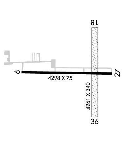
| Lat: N 4256.3 Long: W 08503.6 Elev: 818 Var: +05 Longest Runway: 4298 | ||
| AWOS: 118.9 CTAF: 122.8 | ||
| ||||||||||||||||||||||||||||||||||||||||||||
| ||||||||||||||||||||||||||||||||||||||||||||
| ||||||||||||||||||||||||||||||||||||||||||||
| Rwy | Rwy | |||||||
| 4298x75 | 4298' | 4298x75 | 4298' | |||||
| 4261x340 | 4261' | 4261x340 | 4261' | |||||
| Runway ID | Single Wheel | Double Wheel | Double Tandem Wheel | Dual Double Wheel |
| 10/28 | 19,000 | N/A | N/A | N/A |
| 18/36 | N/A | N/A | N/A | N/A |
| These numbers are Advisory and are not limits. The Airport Manager should have more accurate Weight Limits | ||||
 Airport Diagram might not be current. | |
| Facility Name: | IONIA COUNTY |
| City Name: | IONIA |
| County: | IONIA |
| State abbrev: | MI |
| State Name: | MICHIGAN |
| Ownership: | PUBLICLY OWNED |
| Use: | OPEN TO THE PUBLIC |
| Owner's Name: | IONIA COUNTY |
| Address: | COURT HOUSE, 100 W MAIN ST |
| IONIA, MI 48846-1651 | |
| Owner's Phone: | 616-527-5300 |
| Manager's Name: | MATT KUHNS |
| Address: | 468 E SPRAGUE RD |
| IONIA, MI 48846 | |
| Phone: | 616-523-9136; CELL 616-902-2281. |
| FAA Region: | GREAT LAKES |
| FAA Field Office: | DET |
| Date | Sunrise | Sunset |
|---|---|---|
| 04/25/24 Thursday | 6:42 | 20:35 |
| 04/26/24 Friday | 6:40 | 20:36 |
| 04/27/24 Saturday | 6:39 | 20:37 |
| 04/28/24 Sunday | 6:37 | 20:39 |
| 04/29/24 Monday | 6:36 | 20:40 |
| 04/30/24 Tuesday | 6:35 | 20:41 |
| 05/01/24 Wednesday | 6:33 | 20:42 |
| 05/02/24 Thursday | 6:32 | 20:43 |
| 05/03/24 Friday | 6:30 | 20:44 |
| 05/04/24 Saturday | 6:29 | 20:45 |
| 05/05/24 Sunday | 6:28 | 20:47 |
| 05/06/24 Monday | 6:27 | 20:48 |
| 05/07/24 Tuesday | 6:25 | 20:49 |
| 05/08/24 Wednesday | 6:24 | 20:50 |
| Airport Attendance Schedule | 7 Days A Week 0800-1700; UNATNDD MAJOR HOLS. |
| Airport Status | OPERATIONAL (This Status can change at any time - please check NOTAMS) |
| Airport Lighting Schedule | ACTVT REIL RWY 28; PAPI RWY 10 & 28; MIRL RWY 10/28 - CTAF. |
| Airport Storage Available | Tie Downs, Hanger |
| Extra Services Available | Glider, Flight Instruction, Aircraft Rental, Glider Towing |
| Wind Indicator | YES - (lighted) |
| Control Tower | NO |
| CTAF Frequency | 122.800 |
| Unicom Frequency | 122.800 |
| Rotating Beacon Color | WG |
| Segmented Circle | YES |
| Landing Fee | NO |
| Airport Inspected | STATE - performed by STATE AERONAUTICAL PERSONNEL |
| Inspection Date | 08/11/2022 |
| Type of Fuel Available | Grade 100LL |
| Airframe Repair Service | MAJOR |
| Power Plant Repair Service | MAJOR |
| Latitude | N4256.3 |
| Longitude | W08503.6 (ESTIMATED) |
| Arpt Elevation | 817ft (SURVEYED) |
| Magnetic Variation | 05W |
| 3 miles S | of IONIA |
| Traffic Pattern Altitude | |
| Sectional Chart | CHICAGO |
| Operations (Reported) | Yearly | Avg. Daily |
|---|---|---|
| General Aviation Transient | 10500 | 29 |
| General Aviation Local | 10500 | 29 |
| Air Taxi | 0 | 0 |
| Commerical | 0 | 0 |
| Commuter | 0 | 0 |
| Military | 500 | 1 |
| Aircraft based on Field | |
|---|---|
| General Aviation Singles | 41 |
| General Aviation Multi | 4 |
| Jet Aircraft | 0 |
| General Aviation Helicopters | 0 |
| Military Aircraft | 0 |
| Gliders | 18 |
| Ultralights | 0 |
| FSS on field | NO |
| FSS tie-in | LANSING |
| FSS Phone | 1-800-WX-BRIEF |
| Who issues Notams | LAN |
| Notam D service at airport | YES |
| ARTCC Name | CHICAGO |
| Airport Certification | |
| Aircraft Rescue & Firefighting Index | None |
| Airport of Entry | No |
| Custom Landing Rights | No |
| Joint Civil/Military | No |
| Military Landing rights | YES |
| NATIONAL PLAN OF INTEGRATED AIRPORT SYSTEMS (NPIAS) |
| GRANT AGREEMENTS UNDER FAAP/ADAP/AIP |
| ASSURANCES PURSUANT TO TITLE VI, CIVIL RIGHTS ACT OF 1964 |
| EXTENSIVE SOARING ACTIVITY. |
| ACFT PARKED ADJ TO RWY 10/28 & 18/36 DURG GLDR OPS. |
| GLDR OPS CONDUCTED SOUTH OF RWY 10/28 & WEST OF RWY 18/36; USE FREQ 123.3 IN PRACTICE AREA. GLDRS USE CTAF IN TFC PAT. |
| TREES OBST VIEW BTWN RWY END 18 WITH RWY END 10 & 28. |
| HOSPITAL & HOSPITAL HELI ADJ SOUTH OF RWY 10/28. |
| FOR CD CTC GREAT LAKES APCH AT 269-459-3345, WHEN APCH CLSD CTC CHICAGO ARTCC AT 630-906-8921. |
| RWY 18/3 6 CLSD NOV 15-APR 15. |
Airport Communications & Frequencies:
| |||||||||||||||||
| Runway: 10 | Runway: 28 | ||
| Mag heading: | 96° | Mag heading: | 276° |
| Rwy Slope: | -.27% Down | Rwy Slope: | .27% Up |
| Approach: | Approach: | ||
| Pattern: | Left Traffic | Pattern: | Left Traffic |
| Markings: | NONPRECISION INSTRUMENT | Markings: | NONPRECISION INSTRUMENT |
| Marking Condition: | FAIR | Marking Condition: | FAIR |
| Arresting Dev: | Arresting Dev: | ||
| Lat & Long: | N4256.3 W08504.3 | Lat. & Long.: | N4256.3 W08503.3 |
| Elev: | 813.8 ft. MSL | Elev: | 802.4 ft. MSL |
| TCH: | 25 ft. AGL | TCH: | 22 ft. AGL |
| Visual Glide Path: | 3.00 degrees | Visual Glide Path: | 3.00 degrees |
| Displaced Threshold: | No | Displaced Threshold: | No |
| Touchdown Zone: | YES | Touchdown Zone: | YES |
| Touchdown Elev.: | 814.0 feet | Touchdown Elev.: | 812.5 feet |
| Visual Glide Slope: | 4-Light PAPI on LEFT side of Runway | Visual Glide Slope: | 4-Light PAPI on LEFT side of Runway |
| RVR Equipment: | RVR Equipment: | ||
| RVV Equipment: | NO | RVV Equipment: | NO |
| Approach Lights: | Approach Lights: | ||
| REIL: | NO | REIL: | YES |
| Centerline Lights: | NO | Centerline Lights: | NO |
| Touchdown lights: | NO | Touchdown lights: | NO |
| Runway Category: | Runway with a Non-precision Approach | Runway Category: | Runway with a Non-precision Approach |
| Declared Distances: | Declared Distances: | ||
| Obstructions: | ALSO +25 FT PLINE, 1154 FT DIST, 38:1. | Obstructions: | |
| Marked: | NOT Marked/Lighted | Marked: | |
| Clearance slope: | 20:1 | Clearance slope: | 20:1 |
| Obstruction height: | Obstruction height: | ||
| Dist. from runway: | Dist. from runway: | ||
| Centerline offset: | Centerline offset: | ||
| Comments: | Comments: |
| Runway: 18 | Runway: 36 | ||
| Mag heading: | 185° | Mag heading: | 5° |
| Rwy Slope: | .33% Up | Rwy Slope: | -.33% Down |
| Approach: | Approach: | ||
| Pattern: | Left Traffic | Pattern: | Left Traffic |
| Markings: | Markings: | ||
| Marking Condition: | 3 FT YELLOW CONES. | Marking Condition: | 3 FT YELLOW CONES. |
| Arresting Dev: | Arresting Dev: | ||
| Lat & Long: | N4256.6 W08503.5 | Lat. & Long.: | N4255.9 W08503.5 |
| Elev: | 803.5 ft. MSL | Elev: | 817.6 ft. MSL |
| TCH: | TCH: | ||
| Visual Glide Path: | Visual Glide Path: | ||
| Displaced Threshold: | No | Displaced Threshold: | No |
| Touchdown Zone: | YES | Touchdown Zone: | YES |
| Touchdown Elev.: | 803.7 feet | Touchdown Elev.: | 817.8 feet |
| Visual Glide Slope: | Visual Glide Slope: | ||
| RVR Equipment: | RVR Equipment: | ||
| RVV Equipment: | NO | RVV Equipment: | NO |
| Approach Lights: | Approach Lights: | ||
| REIL: | NO | REIL: | NO |
| Centerline Lights: | NO | Centerline Lights: | NO |
| Touchdown lights: | NO | Touchdown lights: | NO |
| Runway Category: | Runway with a Visual Approach | Runway Category: | Runway with a Visual Approach |
| Declared Distances: | Declared Distances: | ||
| Obstructions: | TREE | Obstructions: | TREE; ALSO +33 FT PLINE, 1015 FT DIST, 30:1. |
| Marked: | NOT Marked/Lighted | Marked: | NOT Marked/Lighted |
| Clearance slope: | 12:1 | Clearance slope: | 12:1 |
| Obstruction height: | 93 feet AGL | Obstruction height: | 84 feet AGL |
| Dist. from runway: | 1126 feet | Dist. from runway: | 1020 feet |
| Centerline offset: | 170 right of centerline | Centerline offset: | 227 feet right of centerline |
| Comments: | Comments: |
Thanks for using FltPlan.com
all rights reserved © 1999-2024 by Flight Plan LLC
