
| ORLANDO APOPKA APOPKA FL |
| |
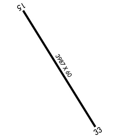
| Lat: N 2842.4 Long: W 08134.9 Elev: 150 Var: +06 Longest Runway: 3987 | ||
| CTAF: 123.05 | ||
| ||||||||||||||||||||||||||||||||||||||||||||
| ||||||||||||||||||||||||||||||||||||||||||||
| Rwy | Rwy | |||||||
| 3987x60 | 3044' | 3987x60 | 3987' | |||||
| Runway ID | Single Wheel | Double Wheel | Double Tandem Wheel | Dual Double Wheel |
| 15/33 | N/A | N/A | N/A | N/A |
| These numbers are Advisory and are not limits. The Airport Manager should have more accurate Weight Limits | ||||
 Airport Diagram might not be current. | |
| Facility Name: | ORLANDO APOPKA |
| City Name: | APOPKA |
| County: | ORANGE |
| State abbrev: | FL |
| State Name: | FLORIDA |
| Ownership: | PRIVATELY OWNED |
| Use: | OPEN TO THE PUBLIC |
| Owner's Name: | ORLANDO APOPKA ARPT CONDO ASSOC. |
| Address: | 882 JACKSON AVE., REGISTERED AGENT |
| WINTER PARK, FL 32789 | |
| Owner's Phone: | 407-647-2622 |
| Manager's Name: | BOB JACKSON |
| Address: | 1321 APOPKA AIRPORT RD HANGAR 37 |
| APOPKA, FL 32712 | |
| Phone: | 407-308-5904 |
| FAA Region: | SOUTHERN |
| FAA Field Office: | ORL |

| Date | Sunrise | Sunset |
|---|---|---|
| 04/25/24 Thursday | 6:50 | 19:59 |
| 04/26/24 Friday | 6:49 | 19:59 |
| 04/27/24 Saturday | 6:48 | 20:00 |
| 04/28/24 Sunday | 6:47 | 20:00 |
| 04/29/24 Monday | 6:46 | 20:01 |
| 04/30/24 Tuesday | 6:46 | 20:02 |
| 05/01/24 Wednesday | 6:45 | 20:02 |
| 05/02/24 Thursday | 6:44 | 20:03 |
| 05/03/24 Friday | 6:43 | 20:03 |
| 05/04/24 Saturday | 6:42 | 20:04 |
| 05/05/24 Sunday | 6:42 | 20:05 |
| 05/06/24 Monday | 6:41 | 20:05 |
| 05/07/24 Tuesday | 6:40 | 20:06 |
| 05/08/24 Wednesday | 6:39 | 20:07 |
| Airport Attendance Schedule | 7 Days A Week 0800-1800 |
| Airport Status | OPERATIONAL (This Status can change at any time - please check NOTAMS) |
| Airport Lighting Schedule | PAPI 15 & 33 ON CONT DURG DALGT. AFTER SS, ACTVT PAPI RWY 15 & 33; LIRL RWY 15/33 - CTAF. |
| Airport Storage Available | Tie Downs, Hanger |
| Extra Services Available | Avionics, Charter, Flight Instruction, Aircraft Rental, Aircraft Sales, Annual Surveying |
| Wind Indicator | YES - (lighted) |
| Control Tower | NO |
| CTAF Frequency | 123.050 |
| Unicom Frequency | 123.050 |
| Rotating Beacon Color | WG |
| Segmented Circle | Y-L |
| Landing Fee | NO |
| Airport Inspected | STATE - performed by STATE AERONAUTICAL PERSONNEL |
| Inspection Date | 08/17/2018 |
| Type of Fuel Available | Grade 100LL, JET A (freeze point -40C) |
| Airframe Repair Service | MAJOR |
| Power Plant Repair Service | MAJOR |
| Latitude | N2842.4 |
| Longitude | W08134.9 (ESTIMATED) |
| Arpt Elevation | 150ft (ESTIMATED) |
| Magnetic Variation | 06W |
| 4 miles NW | of APOPKA |
| Traffic Pattern Altitude | |
| Sectional Chart | JACKSONVILLE |
| Operations (Reported) | Yearly | Avg. Daily |
|---|---|---|
| General Aviation Transient | 3700 | 10 |
| General Aviation Local | 29200 | 80 |
| Air Taxi | 250 | 1 |
| Commerical | 0 | 0 |
| Commuter | 0 | 0 |
| Military | 0 | 0 |
| Aircraft based on Field | |
|---|---|
| General Aviation Singles | 196 |
| General Aviation Multi | 32 |
| Jet Aircraft | 3 |
| General Aviation Helicopters | 4 |
| Military Aircraft | 0 |
| Gliders | 2 |
| Ultralights | 12 |
| FSS on field | NO |
| FSS tie-in | SAINT PETERSBURG |
| FSS Phone | 1-800-WX-BRIEF |
| Who issues Notams | PIE |
| Notam D service at airport | YES |
| ARTCC Name | JACKSONVILLE |
| Airport Certification | |
| Aircraft Rescue & Firefighting Index | None |
| Airport of Entry | No |
| Custom Landing Rights | No |
| Joint Civil/Military | No |
| Military Landing rights | No |
| STEEP DROPOFF 63 FT FM SE END & APRXLY 60 FT OFF WEST & EAST EDGE. |
| RY 15/33 RR PENETRATES 7:1 TRANS SFC EAST SIDE. |
| RY 15/33 CLSD TO TOUCH AND GO LNDGS BY TRANSIENT HELICOPTERS. |
| FOR CD CTC JACKSONVILLE ARTCC AT 904-845-1592. |
| AUTOMATED UNICOM WX AND LGT - CTAF. |
| NO OVNGT PRKG ON APRON BTN TWY A1 AND A2. |
| NO OVNGT RAMP PRKG AVBL - TEXT 951-818-8408 FOR PAID PVT PRKG OPTIONS. |
| PWRD PARAGLIDERS OPERATING W OF RWY 15/33. |
Airport Communications & Frequencies:
| ||||||||||||||
| Runway: 15 | Runway: 33 | ||
| Mag heading: | N/A | Mag heading: | N/A |
| Rwy Slope: | -.43% Down | Rwy Slope: | .43% Up |
| Approach: | Approach: | ||
| Pattern: | Right Traffic | Pattern: | Left Traffic |
| Markings: | BASIC | Markings: | BASIC |
| Marking Condition: | GOOD | Marking Condition: | GOOD |
| Arresting Dev: | Arresting Dev: | ||
| Lat & Long: | N2842.7 W08135.1 | Lat. & Long.: | N2842.2 W08134.7 |
| Elev: | 142.2 ft. MSL | Elev: | 125.2 ft. MSL |
| TCH: | 10 ft. AGL | TCH: | 25 ft. AGL |
| Visual Glide Path: | 3.50 degrees | Visual Glide Path: | 3.00 degrees |
| Displaced Threshold: | 943 feet | Displaced Threshold: | No |
| Touchdown Zone: | YES | Touchdown Zone: | YES |
| Touchdown Elev.: | 150.0 feet | Touchdown Elev.: | 127.5 feet |
| Visual Glide Slope: | 2-Light PAPI on LEFT side of Runway | Visual Glide Slope: | 2-Light PAPI on LEFT side of Runway |
| RVR Equipment: | RVR Equipment: | ||
| RVV Equipment: | NO | RVV Equipment: | NO |
| Approach Lights: | Approach Lights: | ||
| REIL: | NO | REIL: | NO |
| Centerline Lights: | NO | Centerline Lights: | NO |
| Touchdown lights: | NO | Touchdown lights: | NO |
| Runway Category: | Runway with a Visual Approach | Runway Category: | Runway with a Visual Approach |
| Declared Distances: | TORA:3987' TODA:3987' ASDA:3987' LDA:3044' | Declared Distances: | TODA:3987' ASDA:3987' LDA:3987' |
| Obstructions: | BERM | Obstructions: | TREES |
| Marked: | NOT Marked/Lighted | Marked: | NOT Marked/Lighted |
| Clearance slope: | 1:1; RY 15 APCH RATIO 20:1 FM DSPLCD THLD DUE TO 33 FT RR TRACK 420 FROM END OF RY 125 L OF CNTRLN. | Clearance slope: | 34:1 |
| Obstruction height: | 10 feet AGL | Obstruction height: | 57 feet AGL |
| Dist. from runway: | 200 feet | Dist. from runway: | 2170 feet |
| Centerline offset: | 125 left of centerline | Centerline offset: | 150 feet left of centerline |
| Comments: | RWY 15 HAS 10 FT BERM 200 FT FM RWY END 125 FT LEFT. | Comments: |
Thanks for using FltPlan.com
all rights reserved © 1999-2024 by Flight Plan LLC