
| GENERAL WM J FOX AIRFIELD LANCASTER CA |
| |
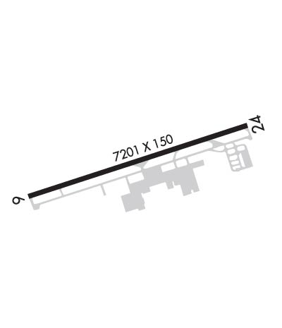
| Lat: N 3444.5 Long: W 11813.1 Elev: 2351 Var: -15 Longest Runway: 7201 | ||
| Dept. ATIS: 126.3 Arr. ATIS: 126.3 AWOS: 133.87 Ground: 121.7 Tower: 118.52 | ||
| ||||||||||||||||||||||||||||||||||||||||||||
| ||||||||||||||||||||||||||||||||||||||||||||
| ||||||||||||||||||||||||||||||||||||||||||||
| ||||||||||||||||||||||||||||||||||||||||||||
| ||||||||||||||||||||||||||||||||||||||||||||
| ||||||||||||||||||||||||||||||||||||||||||||
| ||||||||||||||||||||||||||||||||||||||||||||
| Rwy | Rwy | |||||||
| 7201x150 | 7201' | 7201x150 | 7201' | |||||
| Runway ID | Single Wheel | Double Wheel | Double Tandem Wheel | Dual Double Wheel |
| 06/24 | 50,000 | 68,000 | 117,000 | N/A |
| These numbers are Advisory and are not limits. The Airport Manager should have more accurate Weight Limits | ||||
 Airport Diagram might not be current. | |
| Facility Name: | GENERAL WM J FOX AIRFIELD |
| City Name: | LANCASTER |
| County: | LOS ANGELES |
| State abbrev: | CA |
| State Name: | CALIFORNIA |
| Ownership: | PUBLICLY OWNED |
| Use: | OPEN TO THE PUBLIC |
| Owner's Name: | CO OF LOS ANGELES |
| Address: | PO BOX 1460 |
| ALHAMBRA, CA 91802-1460 | |
| Owner's Phone: | 626-300-4600; LA COUNTY CTC: PAUL MASELBAS, 626-300-4600 X4615. |
| Manager's Name: | SAMUEL MAGHAKIAN |
| Address: | 4725 WILLIAM J BARNES AVE |
| LANCASTER, CA 93536 | |
| Phone: | 661-940-1709 |
| FAA Region: | WESTERN-PACIFIC |
| FAA Field Office: | LAX |
| Date | Sunrise | Sunset |
|---|---|---|
| 04/24/24 Wednesday | 6:09 | 19:33 |
| 04/25/24 Thursday | 6:08 | 19:34 |
| 04/26/24 Friday | 6:07 | 19:35 |
| 04/27/24 Saturday | 6:06 | 19:35 |
| 04/28/24 Sunday | 6:05 | 19:36 |
| 04/29/24 Monday | 6:04 | 19:37 |
| 04/30/24 Tuesday | 6:03 | 19:38 |
| 05/01/24 Wednesday | 6:02 | 19:39 |
| 05/02/24 Thursday | 6:01 | 19:39 |
| 05/03/24 Friday | 6:00 | 19:40 |
| 05/04/24 Saturday | 5:59 | 19:41 |
| 05/05/24 Sunday | 5:58 | 19:42 |
| 05/06/24 Monday | 5:57 | 19:43 |
| 05/07/24 Tuesday | 5:56 | 19:43 |
| Airport Attendance Schedule | CONTINUOUS |
| Airport Status | OPERATIONAL (This Status can change at any time - please check NOTAMS) |
| Airport Lighting Schedule | ARPT LGTS ON CONTINUOUSLY, WHEN ATCT CLSD. |
| Airport Storage Available | Tie Downs |
| Extra Services Available | Avionics, Charter, Flight Instruction, Aircraft Rental, Aircraft Sales |
| Wind Indicator | YES - (lighted) |
| Control Tower | YES |
| CTAF Frequency | 118.525 |
| Unicom Frequency | 122.950 |
| Rotating Beacon Color | WG |
| Segmented Circle | YES |
| Landing Fee | NO |
| Airport Inspected | STATE - performed by STATE AERONAUTICAL PERSONNEL |
| Inspection Date | 06/02/2023 |
| Type of Fuel Available | Grade 100LL, JET A (freeze point -40C) |
| Airframe Repair Service | MAJOR |
| Power Plant Repair Service | MAJOR |
| Latitude | N3444.5 |
| Longitude | W11813.1 (ESTIMATED) |
| Arpt Elevation | 2350ft (SURVEYED) |
| Magnetic Variation | 15E |
| 4 miles NW | of LANCASTER |
| Traffic Pattern Altitude | 800 |
| Sectional Chart | LOS ANGELES |
| Operations (Reported) | Yearly | Avg. Daily |
|---|---|---|
| General Aviation Transient | 21459 | 59 |
| General Aviation Local | 24916 | 68 |
| Air Taxi | 594 | 2 |
| Commerical | 0 | 0 |
| Commuter | 0 | 0 |
| Military | 1215 | 3 |
| Aircraft based on Field | |
|---|---|
| General Aviation Singles | 56 |
| General Aviation Multi | 2 |
| Jet Aircraft | 0 |
| General Aviation Helicopters | 0 |
| Military Aircraft | 0 |
| Gliders | 2 |
| Ultralights | 0 |
| FSS on field | NO |
| FSS tie-in | RIVERSIDE |
| FSS Phone | 1-800-WX-BRIEF |
| Who issues Notams | WJF |
| Notam D service at airport | YES |
| ARTCC Name | LOS ANGELES |
| Airport Certification | |
| Aircraft Rescue & Firefighting Index | None |
| Airport of Entry | No |
| Custom Landing Rights | No |
| Joint Civil/Military | No |
| Military Landing rights | YES |
| NATIONAL PLAN OF INTEGRATED AIRPORT SYSTEMS (NPIAS) |
| GRANT AGREEMENTS UNDER FAAP/ADAP/AIP |
| ASSURANCES PURSUANT TO TITLE VI, CIVIL RIGHTS ACT OF 1964 |
| THIS AIRPORT HAS BEEN SURVEYED BY THE NATIONAL GEODETIC SURVEY. |
| FOREST SVC FIRE FIGHTING STN ON ARPT MAY-DEC. |
| NUMEROUS BIRDS SE OF ARPT. |
| PAEW ADJACENT RAMP AREA BTN FUEL ISLAND AND TERMINAL BLDG. |
Airport Communications & Frequencies:
| ||||||||||||||||||||||||
| Runway: 06 | Runway: 24 | ||
| Mag heading: | 57° | Mag heading: | 237° |
| Rwy Slope: | -.22% Down | Rwy Slope: | .22% Up |
| Approach: | Approach: | ||
| Pattern: | Left Traffic | Pattern: | Right Traffic |
| Markings: | NONPRECISION INSTRUMENT | Markings: | NONPRECISION INSTRUMENT |
| Marking Condition: | GOOD | Marking Condition: | GOOD |
| Arresting Dev: | Arresting Dev: | ||
| Lat & Long: | N3444.3 W11813.8 | Lat. & Long.: | N3444.6 W11812.4 |
| Elev: | 2350.5 ft. MSL | Elev: | 2334.8 ft. MSL |
| TCH: | 40 ft. AGL | TCH: | 40 ft. AGL |
| Visual Glide Path: | 3.00 degrees | Visual Glide Path: | 3.00 degrees |
| Displaced Threshold: | No | Displaced Threshold: | No |
| Touchdown Zone: | YES | Touchdown Zone: | YES |
| Touchdown Elev.: | 2350.5 feet | Touchdown Elev.: | 2340.6 feet |
| Visual Glide Slope: | 4-Light PAPI on LEFT side of Runway | Visual Glide Slope: | 4-Light PAPI on LEFT side of Runway |
| RVR Equipment: | RVR Equipment: | ||
| RVV Equipment: | NO | RVV Equipment: | NO |
| Approach Lights: | Approach Lights: | ||
| REIL: | YES | REIL: | YES |
| Centerline Lights: | NO | Centerline Lights: | NO |
| Touchdown lights: | NO | Touchdown lights: | NO |
| Runway Category: | Runway with a Non-precision Approach having visibility minimums greater than 3/4 mile | Runway Category: | Runway with a Non-precision Approach having visibility minimums greater than 3/4 mile |
| Declared Distances: | Declared Distances: |
Thanks for using FltPlan.com
all rights reserved © 1999-2024 by Flight Plan LLC
