
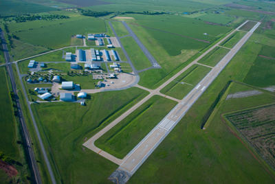
| ENID WOODRING RGNL ENID OK |
| |
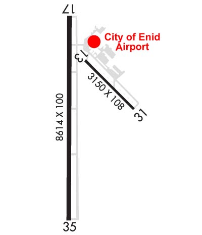
| Lat: N 3622.6 Long: W 09747.4 Elev: 1167 Var: -05 Longest Runway: 8613 | ||
| AWOS: 120.62 Ground: 121.92 Tower: 118.9 | ||
| |||||||||||||||||||||||||||||||||||||||||||||||||||||||||||||||||||||
| |||||||||||||||||||||||||||||||||||||||||||||||||||||||||||||||||||||
| |||||||||||||||||||||||||||||||||||||||||||||||||||||||||||||||||||||
| Rwy | Rwy | |||||||
| 3150x108 | 3038' | 3150x108 | 3150' | |||||
| 8613x100 | 8002' | 8613x100 | 8613' | 108.30 - 355° | ||||
| Runway ID | Single Wheel | Double Wheel | Double Tandem Wheel | Dual Double Wheel |
| 13/31 | 16,000 | N/A | N/A | N/A |
| 17/35 | 60,000 | 73,000 | 131,000 | N/A |
| These numbers are Advisory and are not limits. The Airport Manager should have more accurate Weight Limits | ||||
 Airport Diagram might not be current. | |
| Facility Name: | ENID WOODRING RGNL |
| City Name: | ENID |
| County: | GARFIELD |
| State abbrev: | OK |
| State Name: | OKLAHOMA |
| Ownership: | PUBLICLY OWNED |
| Use: | OPEN TO THE PUBLIC |
| Owner's Name: | CITY OF ENID |
| Address: | PO BOX 1768 |
| ENID, OK 73702 | |
| Owner's Phone: | 580-234-0400 |
| Manager's Name: | KESTON COOK |
| Address: | 1026 SOUTH 66TH STREET |
| ENID, OK 73701 | |
| Phone: | 580-616-7386 |
| FAA Region: | SOUTHWEST |
| FAA Field Office: | AOK |
| Date | Sunrise | Sunset |
|---|---|---|
| 04/25/24 Thursday | 6:44 | 20:15 |
| 04/26/24 Friday | 6:43 | 20:15 |
| 04/27/24 Saturday | 6:42 | 20:16 |
| 04/28/24 Sunday | 6:40 | 20:17 |
| 04/29/24 Monday | 6:39 | 20:18 |
| 04/30/24 Tuesday | 6:38 | 20:19 |
| 05/01/24 Wednesday | 6:37 | 20:20 |
| 05/02/24 Thursday | 6:36 | 20:21 |
| 05/03/24 Friday | 6:35 | 20:21 |
| 05/04/24 Saturday | 6:34 | 20:22 |
| 05/05/24 Sunday | 6:33 | 20:23 |
| 05/06/24 Monday | 6:32 | 20:24 |
| 05/07/24 Tuesday | 6:31 | 20:25 |
| 05/08/24 Wednesday | 6:30 | 20:26 |
| Airport Attendance Schedule | 7 Days A Week 0600-2130 |
| Airport Status | OPERATIONAL (This Status can change at any time - please check NOTAMS) |
| Airport Lighting Schedule | WHEN ATCT CLSD ACTVT MALSR RWY 35; REIL RWY 17; MIRL RWY 17/35 & 13/31 - CTAF. PAPI RWY 17 & 35 OPER CONSLY. |
| Airport Storage Available | Tie Downs, Hanger |
| Extra Services Available | Air Freight, Flight Instruction, Aircraft Rental |
| Wind Indicator | YES - (lighted) |
| Control Tower | YES |
| CTAF Frequency | 118.900 |
| Unicom Frequency | |
| Rotating Beacon Color | WG |
| Segmented Circle | YES |
| Landing Fee | NO |
| Airport Inspected | STATE - performed by STATE AERONAUTICAL PERSONNEL |
| Inspection Date | 02/11/2022 |
| Type of Fuel Available | Grade 100LL, JET A (freeze point -40C); -10FUEL AVBL 24 HRS. SELF SVC AVGAS AVBL. FOR JET A FUEL AFT HRS CALL(580) 231-0189. |
| Airframe Repair Service | MINOR |
| Power Plant Repair Service | MINOR |
| Latitude | N3622.6 |
| Longitude | W09747.4 (ESTIMATED) |
| Arpt Elevation | 1167ft (SURVEYED) |
| Magnetic Variation | 05E |
| 4 miles SE | of ENID |
| Traffic Pattern Altitude | |
| Sectional Chart | WICHITA |
| Operations (Reported) | Yearly | Avg. Daily |
|---|---|---|
| General Aviation Transient | 7363 | 20 |
| General Aviation Local | 3697 | 10 |
| Air Taxi | 678 | 2 |
| Commerical | 0 | 0 |
| Commuter | 0 | 0 |
| Military | 23262 | 64 |
| Aircraft based on Field | |
|---|---|
| General Aviation Singles | 70 |
| General Aviation Multi | 6 |
| Jet Aircraft | 3 |
| General Aviation Helicopters | 0 |
| Military Aircraft | 0 |
| Gliders | 0 |
| Ultralights | 1 |
| FSS on field | NO |
| FSS tie-in | MC ALESTER |
| FSS Phone | 1-800-WX-BRIEF |
| Who issues Notams | WDG |
| Notam D service at airport | YES |
| ARTCC Name | KANSAS CITY |
| Airport Certification | |
| Aircraft Rescue & Firefighting Index | None |
| Airport of Entry | No |
| Custom Landing Rights | No |
| Joint Civil/Military | No |
| Military Landing rights | YES |
| NATIONAL PLAN OF INTEGRATED AIRPORT SYSTEMS (NPIAS) |
| GRANT AGREEMENTS UNDER FAAP/ADAP/AIP |
| ASSURANCES PURSUANT TO TITLE VI, CIVIL RIGHTS ACT OF 1964 |
| AGREEMENT UNDER DLAND OR DCLA HAS EXPIRED. |
| MIL JET TRNG DRG DALGT HRS INVOF ARPT. |
| NOISE SENSITIVE AREA 3/4NM NW. ALL ACFT DEP RWY 35 CLIMB 500FT AGL PRIOR TO TURNING CROSSWIND TO WEST. |
| FOR CD CTC VANCE APCH C580-213-6765. WHEN VANCE APCH CLSD, CTC KANSAS CITY ARTCC 913-254-8508. |
| RWY 13/3 1 RWY 13/31 MOD TO SEVERE CRACKING, RAVELING, PONDING, & GRASS GROWING THROUGH CRACKS. |
Airport Communications & Frequencies:
| |||||||||||||||||||||||
| Runway: 13 | Runway: 31 | ||
| Mag heading: | 130° | Mag heading: | 310° |
| Rwy Slope: | -.04% Down | Rwy Slope: | .04% Up |
| Approach: | Approach: | ||
| Pattern: | Left Traffic | Pattern: | Right Traffic |
| Markings: | BASIC | Markings: | BASIC |
| Marking Condition: | GOOD | Marking Condition: | GOOD |
| Arresting Dev: | Arresting Dev: | ||
| Lat & Long: | N3622.9 W09747.3 | Lat. & Long.: | N3622.5 W09746.9 |
| Elev: | 1158.7 ft. MSL | Elev: | 1157.4 ft. MSL |
| TCH: | TCH: | ||
| Visual Glide Path: | Visual Glide Path: | ||
| Displaced Threshold: | 112 feet | Displaced Threshold: | No |
| Touchdown Zone: | YES | Touchdown Zone: | YES |
| Touchdown Elev.: | 1158.7 feet | Touchdown Elev.: | 1158.7 feet |
| Visual Glide Slope: | Visual Glide Slope: | ||
| RVR Equipment: | RVR Equipment: | ||
| RVV Equipment: | NO | RVV Equipment: | NO |
| Approach Lights: | Approach Lights: | ||
| REIL: | NO | REIL: | NO |
| Centerline Lights: | NO | Centerline Lights: | NO |
| Touchdown lights: | NO | Touchdown lights: | NO |
| Runway Category: | Runway with a Visual Approach | Runway Category: | Runway with a Visual Approach |
| Declared Distances: | Declared Distances: |
| Runway: 17 | Runway: 35 | ||
| Mag heading: | 175° | Mag heading: | 355° |
| Rwy Slope: | -.35% Down | Rwy Slope: | .35% Up |
| Approach: | Approach: | ILS | |
| Pattern: | Left Traffic | Pattern: | Right Traffic |
| Markings: | PRECISION INSTRUMENT | Markings: | PRECISION INSTRUMENT |
| Marking Condition: | GOOD | Marking Condition: | GOOD |
| Arresting Dev: | Arresting Dev: | ||
| Lat & Long: | N3623.2 W09747.5 | Lat. & Long.: | N3621.8 W09747.5 |
| Elev: | 1167.2 ft. MSL | Elev: | 1137.3 ft. MSL |
| TCH: | 52 ft. AGL | TCH: | 49 ft. AGL |
| Visual Glide Path: | 3.00 degrees | Visual Glide Path: | 3.00 degrees |
| Displaced Threshold: | 611 feet | Displaced Threshold: | No |
| Touchdown Zone: | YES | Touchdown Zone: | YES |
| Touchdown Elev.: | 1164.6 feet | Touchdown Elev.: | 1147.2 feet |
| Visual Glide Slope: | 4-Light PAPI on LEFT side of Runway | Visual Glide Slope: | 4-Light PAPI on LEFT side of Runway |
| RVR Equipment: | RVR Equipment: | ||
| RVV Equipment: | NO | RVV Equipment: | NO |
| Approach Lights: | Approach Lights: | MALSR - 1,400 foot medium intensity approach lighting system with runway alignment indicator lights | |
| REIL: | YES | REIL: | NO |
| Centerline Lights: | NO | Centerline Lights: | NO |
| Touchdown lights: | NO | Touchdown lights: | NO |
| Runway Category: | D | Runway Category: | Precision Instrument Runway |
| Declared Distances: | Declared Distances: | ||
| Obstructions: | ROAD | Obstructions: | |
| Marked: | NOT Marked/Lighted | Marked: | |
| Clearance slope: | 4:1 | Clearance slope: | 50:1 |
| Obstruction height: | 20 feet AGL | Obstruction height: | |
| Dist. from runway: | 284 feet | Dist. from runway: | |
| Centerline offset: | 512 left of centerline | Centerline offset: | |
| Comments: | Comments: |
Thanks for using FltPlan.com
all rights reserved © 1999-2024 by Flight Plan LLC


