| GRANT COUNTY PETERSBURG WV |
| |
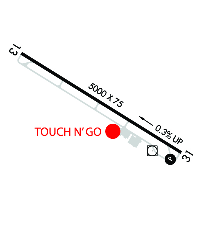
| Lat: N 3859.7 Long: W 07908.8 Elev: 963 Var: +08 Longest Runway: 5000 | ||
| AWOS: 124.47 CTAF: 122.8 | ||
| |||||||||||||||||||||||||||||||||||||||||||||||||||||||||||||
| |||||||||||||||||||||||||||||||||||||||||||||||||||||||||||||
| |||||||||||||||||||||||||||||||||||||||||||||||||||||||||||||
| Rwy | Rwy | |||||||
| 5000x75 | 5000' | 5000x75 | 5000' | 111.50 - 285° | ||||
| Runway ID | Single Wheel | Double Wheel | Double Tandem Wheel | Dual Double Wheel |
| 13/31 | 41,000 | 53,400 | N/A | N/A |
| These numbers are Advisory and are not limits. The Airport Manager should have more accurate Weight Limits | ||||
 Airport Diagram might not be current. | |
| Facility Name: | GRANT COUNTY |
| City Name: | PETERSBURG |
| County: | GRANT |
| State abbrev: | WV |
| State Name: | WEST VIRGINIA |
| Ownership: | PUBLICLY OWNED |
| Use: | OPEN TO THE PUBLIC |
| Owner's Name: | GRANT COUNTY AIRPORT AUTH |
| Address: | 5 HIGHLAND AVE |
| PETERSBURG, WV 26847 | |
| Owner's Phone: | 304-257-4435 |
| Manager's Name: | TOM FEASTER |
| Address: | 440 AIRPORT RD |
| PETERSBURG, WV 26802 | |
| Phone: | 304-257-4435 |
| FAA Region: | EASTERN |
| FAA Field Office: | BKW |
| Date | Sunrise | Sunset |
|---|---|---|
| 04/26/24 Friday | 6:24 | 20:05 |
| 04/27/24 Saturday | 6:23 | 20:06 |
| 04/28/24 Sunday | 6:21 | 20:07 |
| 04/29/24 Monday | 6:20 | 20:08 |
| 04/30/24 Tuesday | 6:19 | 20:09 |
| 05/01/24 Wednesday | 6:18 | 20:10 |
| 05/02/24 Thursday | 6:16 | 20:11 |
| 05/03/24 Friday | 6:15 | 20:12 |
| 05/04/24 Saturday | 6:14 | 20:13 |
| 05/05/24 Sunday | 6:13 | 20:14 |
| 05/06/24 Monday | 6:12 | 20:15 |
| 05/07/24 Tuesday | 6:11 | 20:16 |
| 05/08/24 Wednesday | 6:10 | 20:17 |
| 05/09/24 Thursday | 6:09 | 20:18 |
| Airport Attendance Schedule | 7 Days A Week 0700-1900; AFTR HRS ON CALL 304-209-2603. |
| Airport Status | OPERATIONAL (This Status can change at any time - please check NOTAMS) |
| Airport Lighting Schedule | ACTVT REIL RWY 13 & 31; PAPI RWY 31; MIRL RWY 13/31 - CTAF. |
| Airport Storage Available | Tie Downs, Hanger |
| Extra Services Available | NONE |
| Wind Indicator | YES - (lighted) |
| Control Tower | NO |
| CTAF Frequency | 122.800 |
| Unicom Frequency | 122.800 |
| Rotating Beacon Color | WG |
| Segmented Circle | YES |
| Landing Fee | NO |
| Airport Inspected | STATE - performed by PRIVATE CONTRACT PERSONNEL |
| Inspection Date | 07/12/2023 |
| Type of Fuel Available | Grade 100LL, JET A (freeze point -40C); -10SELF SVC FUEL 24/7. |
| Airframe Repair Service | MAJOR |
| Power Plant Repair Service | MAJOR |
| Latitude | N3859.7 |
| Longitude | W07908.8 (ESTIMATED) |
| Arpt Elevation | 962ft (SURVEYED) |
| Magnetic Variation | 08W |
| 1 miles SW | of PETERSBURG |
| Traffic Pattern Altitude | |
| Sectional Chart | CINCINNATI |
| Operations (Reported) | Yearly | Avg. Daily |
|---|---|---|
| General Aviation Transient | 7200 | 20 |
| General Aviation Local | 7200 | 20 |
| Air Taxi | 0 | 0 |
| Commerical | 0 | 0 |
| Commuter | 0 | 0 |
| Military | 200 | 1 |
| Aircraft based on Field | |
|---|---|
| General Aviation Singles | 13 |
| General Aviation Multi | 1 |
| Jet Aircraft | 0 |
| General Aviation Helicopters | 1 |
| Military Aircraft | 0 |
| Gliders | 3; GLIDER OPS. |
| Ultralights | 0 |
| FSS on field | NO |
| FSS tie-in | ELKINS |
| FSS Phone | 1-800-WX-BRIEF |
| Who issues Notams | EKN |
| Notam D service at airport | YES |
| ARTCC Name | WASHINGTON |
| Airport Certification | |
| Aircraft Rescue & Firefighting Index | None |
| Airport of Entry | No |
| Custom Landing Rights | No |
| Joint Civil/Military | No |
| Military Landing rights | YES |
| NATIONAL PLAN OF INTEGRATED AIRPORT SYSTEMS (NPIAS) |
| GRANT AGREEMENTS UNDER FAAP/ADAP/AIP |
| ASSURANCES PURSUANT TO TITLE VI, CIVIL RIGHTS ACT OF 1964 |
| BIRDS ON & INVOF ARPT. |
| FLY-IN CAMPGROUND ON ARPT. |
| COLD TEMPERATURE AIRPORT. ALTITUDE CORRECTION REQUIRED AT OR BELOW -8C. |
| FOR CD CTC WASHINGTON ARTCC AT 703-771-3587. |
Airport Communications & Frequencies:
| |||||||||
| Runway: 13 | Runway: 31 | ||
| Mag heading: | 130° | Mag heading: | 310° |
| Rwy Slope: | -.30% Down | Rwy Slope: | .30% Up |
| Approach: | Approach: | LDA/DME | |
| Pattern: | Left Traffic | Pattern: | Right Traffic; RIGHT TRAFFIC FOR GLIDER AND ULTRA-LIGHT ONLY. ALL OTHER POWERED AIRCRAFT STANDARD LEFT TRAFFIC PATTERN. |
| Markings: | BASIC | Markings: | NONPRECISION INSTRUMENT |
| Marking Condition: | FAIR | Marking Condition: | FAIR |
| Arresting Dev: | Arresting Dev: | ||
| Lat & Long: | N3859.9 W07909.2 | Lat. & Long.: | N3859.5 W07908.3 |
| Elev: | 962.9 ft. MSL | Elev: | 947.8 ft. MSL |
| TCH: | TCH: | 46 ft. AGL | |
| Visual Glide Path: | Visual Glide Path: | 6.50 degrees | |
| Displaced Threshold: | No | Displaced Threshold: | No |
| Touchdown Zone: | YES | Touchdown Zone: | YES |
| Touchdown Elev.: | 962.9 feet | Touchdown Elev.: | 956.6 feet |
| Visual Glide Slope: | Visual Glide Slope: | 4-Light PAPI on LEFT side of Runway | |
| RVR Equipment: | RVR Equipment: | ||
| RVV Equipment: | NO | RVV Equipment: | NO |
| Approach Lights: | Approach Lights: | ||
| REIL: | YES | REIL: | YES |
| Centerline Lights: | NO | Centerline Lights: | NO |
| Touchdown lights: | NO | Touchdown lights: | NO |
| Runway Category: | Runway with a Visual Approach | Runway Category: | Runway with a Non-precision Approach having visibility minimums greater than 3/4 mile |
| Declared Distances: | Declared Distances: | ||
| Obstructions: | FENCE | Obstructions: | FENCE |
| Marked: | NOT Marked/Lighted | Marked: | NOT Marked/Lighted |
| Clearance slope: | Clearance slope: | 17:1 | |
| Obstruction height: | 6 feet AGL | Obstruction height: | 6 feet AGL |
| Dist. from runway: | 201 feet | Dist. from runway: | 305 feet |
| Centerline offset: | 250 left of centerline | Centerline offset: | 255 feet left of centerline |
| Comments: | Comments: |
Thanks for using FltPlan.com
all rights reserved © 1999-2024 by Flight Plan LLC