
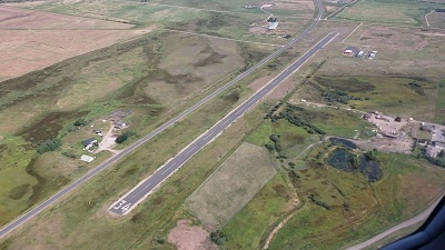
| RIDDICK FIELD PHILIPSBURG MT |
| |
| Lat: N 4619.0 Long: W 11318.3 Elev: 5219 Var: -17 Longest Runway: 3599 | ||
| CTAF: 122.9 | ||
| ||||||||||||||||||||||||||||||||
| ||||||||||||||||||||||||||||||||
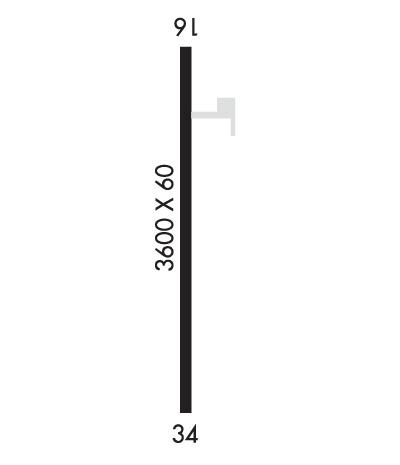
| Rwy | Rwy | |||||||
| 3599x60 | 3599' | 3599x60 | 3599' | |||||
| Runway ID | Single Wheel | Double Wheel | Double Tandem Wheel | Dual Double Wheel |
| 16/34 | 7,000 | N/A | N/A | N/A |
| These numbers are Advisory and are not limits. The Airport Manager should have more accurate Weight Limits | ||||
| FltPlan does not have IFR approach charts available for KU05. |
 Airport Diagram might not be current. | |
| Facility Name: | RIDDICK FLD |
| City Name: | PHILIPSBURG |
| County: | GRANITE |
| State abbrev: | MT |
| State Name: | MONTANA |
| Ownership: | PUBLICLY OWNED |
| Use: | OPEN TO THE PUBLIC |
| Owner's Name: | GRANITE COUNTY |
| Address: | 220 N SANSOME ST, PO BOX 925 |
| PHILIPSBURG, MT 59858 | |
| Owner's Phone: | 406-859-3771 |
| Manager's Name: | DONOVAN JONES |
| Address: | 220 N SANSOME ST, PO BOX 925 |
| PHILIPSBURG, MT 59858 | |
| Phone: | 406-303-1230 |
| FAA Region: | NORTHWEST MOUNTAIN |
| FAA Field Office: | HLN |
| Date | Sunrise | Sunset |
|---|---|---|
| 05/09/24 Thursday | 6:07 | 20:53 |
| 05/10/24 Friday | 6:05 | 20:55 |
| 05/11/24 Saturday | 6:04 | 20:56 |
| 05/12/24 Sunday | 6:03 | 20:57 |
| 05/13/24 Monday | 6:01 | 20:58 |
| 05/14/24 Tuesday | 6:00 | 21:00 |
| 05/15/24 Wednesday | 5:59 | 21:01 |
| 05/16/24 Thursday | 5:58 | 21:02 |
| 05/17/24 Friday | 5:57 | 21:03 |
| 05/18/24 Saturday | 5:56 | 21:04 |
| 05/19/24 Sunday | 5:55 | 21:05 |
| 05/20/24 Monday | 5:54 | 21:07 |
| 05/21/24 Tuesday | 5:53 | 21:08 |
| 05/22/24 Wednesday | 5:52 | 21:09 |
| Airport Attendance Schedule | UNATTENDED |
| Airport Status | OPERATIONAL (This Status can change at any time - please check NOTAMS) |
| Airport Lighting Schedule | ACTVT MIRL RY 16/34 - CTAF. |
| Airport Storage Available | Tie Downs, Hanger |
| Extra Services Available | NONE |
| Wind Indicator | YES - (lighted) |
| Control Tower | NO |
| CTAF Frequency | 122.900 |
| Unicom Frequency | |
| Rotating Beacon Color | WG |
| Segmented Circle | YES |
| Landing Fee | NO |
| Airport Inspected | STATE - performed by STATE AERONAUTICAL PERSONNEL |
| Inspection Date | 04/01/2024 |
| Type of Fuel Available | None |
| Airframe Repair Service | NONE |
| Power Plant Repair Service | NONE |
| Latitude | N4619.0 |
| Longitude | W11318.3 (ESTIMATED) |
| Arpt Elevation | 5219ft (SURVEYED) |
| Magnetic Variation | 17E |
| 1 miles SE | of PHILIPSBURG |
| Traffic Pattern Altitude | |
| Sectional Chart | GREAT FALLS |
| Operations (Reported) | Yearly | Avg. Daily |
|---|---|---|
| General Aviation Transient | 600 | 2 |
| General Aviation Local | 1000 | 3 |
| Air Taxi | 100 | 0 |
| Commerical | 0 | 0 |
| Commuter | 0 | 0 |
| Military | 0 | 0 |
| Aircraft based on Field | |
|---|---|
| General Aviation Singles | 13 |
| General Aviation Multi | 0 |
| Jet Aircraft | 0 |
| General Aviation Helicopters | 0 |
| Military Aircraft | 0 |
| Gliders | 0 |
| Ultralights | 0 |
| FSS on field | NO |
| FSS tie-in | GREAT FALLS |
| FSS Phone | 1-800-WX-BRIEF |
| Who issues Notams | GTF |
| Notam D service at airport | YES |
| ARTCC Name | SALT LAKE CITY |
| Airport Certification | |
| Aircraft Rescue & Firefighting Index | None |
| Airport of Entry | No |
| Custom Landing Rights | No |
| Joint Civil/Military | No |
| Military Landing rights | YES |
| NATIONAL PLAN OF INTEGRATED AIRPORT SYSTEMS (NPIAS) |
| GRANT AGREEMENTS UNDER FAAP/ADAP/AIP |
| ASSURANCES PURSUANT TO TITLE VI, CIVIL RIGHTS ACT OF 1964 |
| FOR CD CTC SALT LAKE ARTCC AT 801-320-2568. |
| SN REMOVAL INTMT. |
| RWY 16/3 4 PAVEMENT IS SPALLING, MAJOR CRACK PROPIGATION THROUGHOUT. MULTIPLE EDGE FRACTURES. |
| Runway: 16 | Runway: 34 | ||
| Mag heading: | 163° | Mag heading: | 343° |
| Rwy Slope: | .59% Up | Rwy Slope: | -.59% Down |
| Approach: | Approach: | ||
| Pattern: | Right Traffic | Pattern: | Left Traffic |
| Markings: | BASIC | Markings: | BASIC |
| Marking Condition: | POOR; MARKINGS FADED | Marking Condition: | POOR; MARKINGS FADED |
| Arresting Dev: | Arresting Dev: | ||
| Lat & Long: | N4619.3 W11318.3 | Lat. & Long.: | N4618.7 W11318.3 |
| Elev: | 5197.8 ft. MSL | Elev: | 5219.0 ft. MSL |
| TCH: | TCH: | ||
| Visual Glide Path: | Visual Glide Path: | ||
| Displaced Threshold: | No | Displaced Threshold: | No |
| Touchdown Zone: | YES | Touchdown Zone: | YES |
| Touchdown Elev.: | 5211.4 feet | Touchdown Elev.: | 5219.0 feet |
| Visual Glide Slope: | Visual Glide Slope: | ||
| RVR Equipment: | RVR Equipment: | ||
| RVV Equipment: | NO | RVV Equipment: | NO |
| Approach Lights: | Approach Lights: | ||
| REIL: | NO | REIL: | NO |
| Centerline Lights: | NO | Centerline Lights: | NO |
| Touchdown lights: | NO | Touchdown lights: | NO |
| Runway Category: | Runway with a Visual Approach | Runway Category: | Runway with a Visual Approach |
| Declared Distances: | Declared Distances: | ||
| Obstructions: | Obstructions: | HILL | |
| Marked: | Marked: | NOT Marked/Lighted | |
| Clearance slope: | 20:1 | Clearance slope: | 15:1 |
| Obstruction height: | Obstruction height: | 263 feet AGL | |
| Dist. from runway: | Dist. from runway: | 4400 feet | |
| Centerline offset: | Centerline offset: | 545 feet right of centerline | |
| Comments: | Comments: |
Thanks for using FltPlan.com
all rights reserved © 1999-2024 by Flight Plan LLC