
| AMERICAN FALLS AMERICAN FALLS ID |
| |
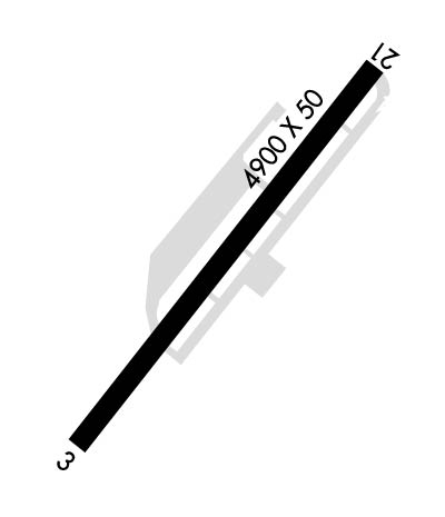
| Lat: N 4247.8 Long: W 11249.5 Elev: 4419 Var: -16 Longest Runway: 4900 | ||
| CTAF: 122.8 | ||
| ||||||||||||||||||||||||||||||||
| ||||||||||||||||||||||||||||||||
| Rwy | Rwy | |||||||
| 4900x50 | 4900' | 4900x50 | 4900' | |||||
| Runway ID | Single Wheel | Double Wheel | Double Tandem Wheel | Dual Double Wheel |
| 03/21 | N/A | N/A | N/A | N/A |
| These numbers are Advisory and are not limits. The Airport Manager should have more accurate Weight Limits | ||||
| FltPlan does not have IFR approach charts available for KU01. |
 Airport Diagram might not be current. | |
| Facility Name: | AMERICAN FALLS |
| City Name: | AMERICAN FALLS |
| County: | POWER |
| State abbrev: | ID |
| State Name: | IDAHO |
| Ownership: | PUBLICLY OWNED |
| Use: | OPEN TO THE PUBLIC |
| Owner's Name: | POWER COUNTY |
| Address: | 543 BANNOCK AVENUE |
| AMERICAN FALLS, ID 83211 | |
| Owner's Phone: | 208-226-7611 |
| Manager's Name: | DALLEN WARD |
| Address: | 5203 MOHAWK |
| POCATELLO, ID 83204-5401 | |
| Phone: | 208-223-6276 |
| FAA Region: | NORTHWEST MOUNTAIN |
| FAA Field Office: | HLN |

| Date | Sunrise | Sunset |
|---|---|---|
| 04/25/24 Thursday | 6:33 | 20:26 |
| 04/26/24 Friday | 6:31 | 20:27 |
| 04/27/24 Saturday | 6:30 | 20:28 |
| 04/28/24 Sunday | 6:29 | 20:29 |
| 04/29/24 Monday | 6:27 | 20:31 |
| 04/30/24 Tuesday | 6:26 | 20:32 |
| 05/01/24 Wednesday | 6:24 | 20:33 |
| 05/02/24 Thursday | 6:23 | 20:34 |
| 05/03/24 Friday | 6:22 | 20:35 |
| 05/04/24 Saturday | 6:20 | 20:36 |
| 05/05/24 Sunday | 6:19 | 20:37 |
| 05/06/24 Monday | 6:18 | 20:38 |
| 05/07/24 Tuesday | 6:17 | 20:40 |
| 05/08/24 Wednesday | 6:15 | 20:41 |
| Airport Attendance Schedule | 7 Days A Week 0800-1800 |
| Airport Status | OPERATIONAL (This Status can change at any time - please check NOTAMS) |
| Airport Lighting Schedule | ACTVT TRCV RWY 21; MIRL RWY 03/21 - CTAF (5 CLICKS). |
| Airport Storage Available | Tie Downs |
| Extra Services Available | Flight Instruction |
| Wind Indicator | YES - (lighted) |
| Control Tower | NO |
| CTAF Frequency | 122.800 |
| Unicom Frequency | 122.800 |
| Rotating Beacon Color | WG |
| Segmented Circle | NO |
| Landing Fee | NO |
| Airport Inspected | STATE - performed by STATE AERONAUTICAL PERSONNEL |
| Inspection Date | 05/16/2022 |
| Type of Fuel Available | Grade 100LL |
| Airframe Repair Service | NONE |
| Power Plant Repair Service | NONE |
| Latitude | N4247.8 |
| Longitude | W11249.5 (ESTIMATED) |
| Arpt Elevation | 4419ft (ESTIMATED) |
| Magnetic Variation | 16E |
| 2 miles NE | of AMERICAN FALLS |
| Traffic Pattern Altitude | |
| Sectional Chart | SALT LAKE CITY |
| Operations (Reported) | Yearly | Avg. Daily |
|---|---|---|
| General Aviation Transient | 13000 | 36 |
| General Aviation Local | 5000 | 14 |
| Air Taxi | 0 | 0 |
| Commerical | 0 | 0 |
| Commuter | 0 | 0 |
| Military | 25 | 0 |
| Aircraft based on Field | |
|---|---|
| General Aviation Singles | 32 |
| General Aviation Multi | 1 |
| Jet Aircraft | 0 |
| General Aviation Helicopters | 3 |
| Military Aircraft | 0 |
| Gliders | 0 |
| Ultralights | 0 |
| FSS on field | NO |
| FSS tie-in | BOISE |
| FSS Phone | 1-800-WX-BRIEF |
| Who issues Notams | BOI |
| Notam D service at airport | YES |
| ARTCC Name | SALT LAKE CITY |
| Airport Certification | |
| Aircraft Rescue & Firefighting Index | None |
| Airport of Entry | No |
| Custom Landing Rights | No |
| Joint Civil/Military | No |
| Military Landing rights | No |
| FREQUENT HELICOPTER OPS YEAR AROUND. |
| IRREGULAR SNOW REMOVAL. |
| NO LINE OF SITE BETWEEN RUNWAY ENDS. |
| FOR CD CTC SALT LAKE ARTCC AT 801-320-2568. |
| Runway: 03 | Runway: 21 | ||
| Mag heading: | 36° | Mag heading: | 216° |
| Rwy Slope: | .01% Up | Rwy Slope: | -.01% Down |
| Approach: | Approach: | ||
| Pattern: | Left Traffic | Pattern: | Left Traffic |
| Markings: | BASIC | Markings: | BASIC |
| Marking Condition: | FAIR | Marking Condition: | FAIR |
| Arresting Dev: | Arresting Dev: | ||
| Lat & Long: | N4247.6 W11249.9 | Lat. & Long.: | N4248.1 W11249.1 |
| Elev: | 4412.7 ft. MSL | Elev: | 4413.2 ft. MSL |
| TCH: | TCH: | 50 ft. AGL | |
| Visual Glide Path: | Visual Glide Path: | 3.50 degrees | |
| Displaced Threshold: | No | Displaced Threshold: | No |
| Touchdown Zone: | YES | Touchdown Zone: | YES |
| Touchdown Elev.: | 4419.0 feet | Touchdown Elev.: | 4419.0 feet |
| Visual Glide Slope: | Visual Glide Slope: | TRI-COLOR VASI ON LEFT SIDE OF RUNWAY | |
| RVR Equipment: | RVR Equipment: | ||
| RVV Equipment: | NO | RVV Equipment: | NO |
| Approach Lights: | Approach Lights: | ||
| REIL: | NO | REIL: | NO |
| Centerline Lights: | NO | Centerline Lights: | NO |
| Touchdown lights: | NO | Touchdown lights: | NO |
| Runway Category: | Runway with a Visual Approach | Runway Category: | Runway with a Visual Approach |
| Declared Distances: | Declared Distances: | ||
| Obstructions: | FENCE | Obstructions: | HILL |
| Marked: | NOT Marked/Lighted | Marked: | NOT Marked/Lighted |
| Clearance slope: | Clearance slope: | 20:1 | |
| Obstruction height: | 4 feet AGL | Obstruction height: | 24 feet AGL |
| Dist. from runway: | 200 feet | Dist. from runway: | 700 feet |
| Centerline offset: | 30 right of centerline | Centerline offset: | |
| Comments: | HAS A 4 FT HIGH FENCE 0 FT FROM THLD AND 30 FT R. | Comments: |
Thanks for using FltPlan.com
all rights reserved © 1999-2024 by Flight Plan LLC