
| MEFFORD FIELD TULARE CA |
| |
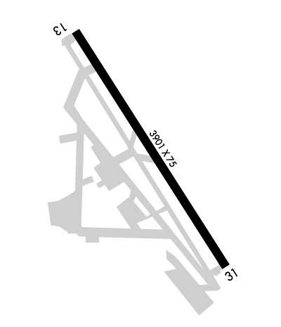
| Lat: N 3609.4 Long: W 11919.6 Elev: 265 Var: -12 Longest Runway: 3901 | ||
| AWOS: 120.0 CTAF: 122.7 | ||
| ||||||||||||||||||||||||||||||||||||||||||||
| ||||||||||||||||||||||||||||||||||||||||||||
| ||||||||||||||||||||||||||||||||||||||||||||
| Rwy | Rwy | |||||||
| 3901x75 | 3901' | 3901x75 | 3901' | |||||
| Runway ID | Single Wheel | Double Wheel | Double Tandem Wheel | Dual Double Wheel |
| 13/31 | 12,500 | N/A | N/A | N/A |
| These numbers are Advisory and are not limits. The Airport Manager should have more accurate Weight Limits | ||||
 Airport Diagram might not be current. | |
| Facility Name: | MEFFORD FLD |
| City Name: | TULARE |
| County: | TULARE |
| State abbrev: | CA |
| State Name: | CALIFORNIA |
| Ownership: | PUBLICLY OWNED |
| Use: | OPEN TO THE PUBLIC |
| Owner's Name: | CITY OF TULARE |
| Address: | 411 EAST KERN AVENUE |
| TULARE, CA 93274 | |
| Owner's Phone: | 559-685-2300 |
| Manager's Name: | JOSH MCDONNELL |
| Address: | 3981 SOUTH K STREET |
| TULARE, CA 93274 | |
| Phone: | 559-684-4201 |
| FAA Region: | WESTERN-PACIFIC |
| FAA Field Office: | SFO |
| Date | Sunrise | Sunset |
|---|---|---|
| 04/24/24 Wednesday | 6:12 | 19:40 |
| 04/25/24 Thursday | 6:10 | 19:40 |
| 04/26/24 Friday | 6:09 | 19:41 |
| 04/27/24 Saturday | 6:08 | 19:42 |
| 04/28/24 Sunday | 6:07 | 19:43 |
| 04/29/24 Monday | 6:06 | 19:44 |
| 04/30/24 Tuesday | 6:05 | 19:45 |
| 05/01/24 Wednesday | 6:04 | 19:46 |
| 05/02/24 Thursday | 6:02 | 19:46 |
| 05/03/24 Friday | 6:01 | 19:47 |
| 05/04/24 Saturday | 6:00 | 19:48 |
| 05/05/24 Sunday | 5:59 | 19:49 |
| 05/06/24 Monday | 5:58 | 19:50 |
| 05/07/24 Tuesday | 5:57 | 19:51 |
| Airport Attendance Schedule | 7 Days A Week 0800-DUSK |
| Airport Status | OPERATIONAL (This Status can change at any time - please check NOTAMS) |
| Airport Lighting Schedule | ACTVT MIRL RWY 13/31 - CTAF. PAPI 13 OPRS CONSLY. |
| Airport Storage Available | Tie Downs |
| Extra Services Available | Crop Dusting, Avionics, Charter, Flight Instruction, Aircraft Rental |
| Wind Indicator | YES - (lighted) |
| Control Tower | NO |
| CTAF Frequency | 122.700 |
| Unicom Frequency | 122.700 |
| Rotating Beacon Color | WG |
| Segmented Circle | YES |
| Landing Fee | NO |
| Airport Inspected | STATE - performed by STATE AERONAUTICAL PERSONNEL |
| Inspection Date | 10/06/2022 |
| Type of Fuel Available | Grade 100LL, JET A (freeze point -40C) |
| Airframe Repair Service | None |
| Power Plant Repair Service | None |
| Latitude | N3609.4 |
| Longitude | W11919.6 (ESTIMATED) |
| Arpt Elevation | 265ft (SURVEYED) |
| Magnetic Variation | 12E |
| 3 miles SE | of TULARE |
| Traffic Pattern Altitude | |
| Sectional Chart | SAN FRANCISCO |
| Operations (Reported) | Yearly | Avg. Daily |
|---|---|---|
| General Aviation Transient | 12000 | 33 |
| General Aviation Local | 13090 | 36 |
| Air Taxi | 0 | 0 |
| Commerical | 0 | 0 |
| Commuter | 0 | 0 |
| Military | 0 | 0 |
| Aircraft based on Field | |
|---|---|
| General Aviation Singles | 26 |
| General Aviation Multi | 0 |
| Jet Aircraft | 0 |
| General Aviation Helicopters | 1 |
| Military Aircraft | 0 |
| Gliders | 0 |
| Ultralights | 0 |
| FSS on field | NO |
| FSS tie-in | RANCHO MURIETA |
| FSS Phone | 1-800-WX-BRIEF |
| Who issues Notams | RIU |
| Notam D service at airport | YES |
| ARTCC Name | OAKLAND |
| Airport Certification | |
| Aircraft Rescue & Firefighting Index | None |
| Airport of Entry | No |
| Custom Landing Rights | No |
| Joint Civil/Military | No |
| Military Landing rights | YES |
| NATIONAL PLAN OF INTEGRATED AIRPORT SYSTEMS (NPIAS) |
| GRANT AGREEMENTS UNDER FAAP/ADAP/AIP |
| ASSURANCES PURSUANT TO TITLE VI, CIVIL RIGHTS ACT OF 1964 |
| THIS AIRPORT HAS BEEN SURVEYED BY THE NATIONAL GEODETIC SURVEY. |
| FOR CD CTC FRESNO APCH AT 559-487-5405. |
Airport Communications & Frequencies:
| |||||||||||||||||
| Runway: 13 | Runway: 31 | ||
| Mag heading: | 135° | Mag heading: | 315° |
| Rwy Slope: | -.07% Down | Rwy Slope: | .07% Up |
| Approach: | Approach: | ||
| Pattern: | Left Traffic | Pattern: | Left Traffic |
| Markings: | NONPRECISION INSTRUMENT | Markings: | NONPRECISION INSTRUMENT |
| Marking Condition: | GOOD | Marking Condition: | GOOD |
| Arresting Dev: | Arresting Dev: | ||
| Lat & Long: | N3609.7 W11919.8 | Lat. & Long.: | N3609.1 W11919.4 |
| Elev: | 265.3 ft. MSL | Elev: | 262.5 ft. MSL |
| TCH: | 42 ft. AGL | TCH: | 40 ft. AGL |
| Visual Glide Path: | 3.00 degrees | Visual Glide Path: | 3.00 degrees |
| Displaced Threshold: | No | Displaced Threshold: | No |
| Touchdown Zone: | YES | Touchdown Zone: | YES |
| Touchdown Elev.: | 265.3 feet | Touchdown Elev.: | 263.7 feet |
| Visual Glide Slope: | 2-Light PAPI on LEFT side of Runway; UNUSBL BYD 7 DEG R OF CNTRLN. | Visual Glide Slope: | 2-Light PAPI on LEFT side of Runway |
| RVR Equipment: | RVR Equipment: | ||
| RVV Equipment: | NO | RVV Equipment: | NO |
| Approach Lights: | Approach Lights: | ||
| REIL: | NO | REIL: | NO |
| Centerline Lights: | NO | Centerline Lights: | NO |
| Touchdown lights: | NO | Touchdown lights: | NO |
| Runway Category: | Runway with a Non-precision Approach | Runway Category: | Runway with a Visual Approach |
| Declared Distances: | Declared Distances: | ||
| Obstructions: | ROAD | Obstructions: | TREES |
| Marked: | NOT Marked/Lighted | Marked: | NOT Marked/Lighted |
| Clearance slope: | 20:1 | Clearance slope: | 8:1; TREES PENETRATE THE APCH 520 FT FROM THE RWY 31 APCH THLD. |
| Obstruction height: | 15 feet AGL | Obstruction height: | 40 feet AGL |
| Dist. from runway: | 500 feet | Dist. from runway: | 520 feet |
| Centerline offset: | 295 right of centerline | Centerline offset: | 150B |
| Comments: | Comments: |
Thanks for using FltPlan.com
all rights reserved © 1999-2024 by Flight Plan LLC
