
| SPACE COAST RGNL TITUSVILLE FL |
| |
| Lat: N 2830.9 Long: W 08048.0 Elev: 34 Var: +05 Longest Runway: 7319 | ||
| Dept. ATIS: 120.62 Arr. ATIS: 120.62 Ground: 121.85 Tower: 118.9 | ||
| |||||||||||||||||||||||||||||||||||||||||||||||||||||||||||||||||||||
| |||||||||||||||||||||||||||||||||||||||||||||||||||||||||||||||||||||
| |||||||||||||||||||||||||||||||||||||||||||||||||||||||||||||||||||||
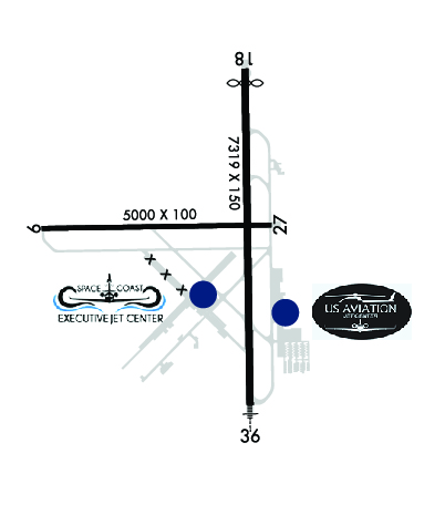
| Rwy | Rwy | |||||||
| 5000x100 | 5000' | 5000x100 | 5000' | |||||
| 7319x150 | 6997' | 7319x150 | 7319' | 108.70 - 004° | ||||
| Runway ID | Single Wheel | Double Wheel | Double Tandem Wheel | Dual Double Wheel |
| 09/27 | 50,000 | 80,000 | N/A | N/A |
| 18/36 | 80,000 | 110,000 | 190,000 | N/A |
| These numbers are Advisory and are not limits. The Airport Manager should have more accurate Weight Limits | ||||
 Airport Diagram might not be current. | |
| Facility Name: | SPACE COAST RGNL |
| City Name: | TITUSVILLE |
| County: | BREVARD |
| State abbrev: | FL |
| State Name: | FLORIDA |
| Ownership: | PUBLICLY OWNED |
| Use: | OPEN TO THE PUBLIC |
| Owner's Name: | TITUSVILLE COCOA ARPT AUTH |
| Address: | 51 BRISTOW WAY |
| TITUSVILLE, FL 32780 | |
| Owner's Phone: | 321-267-8780 |
| Manager's Name: | KEVIN DAUGHERTY, AAE |
| Address: | 355 GOLDEN KNIGHTS BLVD |
| TITUSVILLE, FL 32780 | |
| Phone: | 321-267-8780 |
| FAA Region: | SOUTHERN |
| FAA Field Office: | ORL |
| Date | Sunrise | Sunset |
|---|---|---|
| 04/26/24 Friday | 6:46 | 19:56 |
| 04/27/24 Saturday | 6:45 | 19:56 |
| 04/28/24 Sunday | 6:44 | 19:57 |
| 04/29/24 Monday | 6:44 | 19:58 |
| 04/30/24 Tuesday | 6:43 | 19:58 |
| 05/01/24 Wednesday | 6:42 | 19:59 |
| 05/02/24 Thursday | 6:41 | 19:59 |
| 05/03/24 Friday | 6:40 | 20:00 |
| 05/04/24 Saturday | 6:40 | 20:01 |
| 05/05/24 Sunday | 6:39 | 20:01 |
| 05/06/24 Monday | 6:38 | 20:02 |
| 05/07/24 Tuesday | 6:37 | 20:02 |
| 05/08/24 Wednesday | 6:37 | 20:03 |
| 05/09/24 Thursday | 6:36 | 20:04 |
| Airport Attendance Schedule | 7 Days A Week 0700-2100 |
| Airport Status | OPERATIONAL (This Status can change at any time - please check NOTAMS) |
| Airport Lighting Schedule | WHEN ATCT CLSD ACTVT MALSR RWY 36; REIL RWYS 9, 18, & 27; PAPI RWYS 09, 27, 18, & 36; MIRL RWY 09/27; HIRL RWY 18/36 - CTAF. |
| Airport Storage Available | Tie Downs, Hanger |
| Extra Services Available | Avionics, Charter, Flight Instruction, Aircraft Rental, Aircraft Sales |
| Wind Indicator | YES - (lighted) |
| Control Tower | YES |
| CTAF Frequency | 118.900 |
| Unicom Frequency | 122.950 |
| Rotating Beacon Color | WG |
| Segmented Circle | NO |
| Landing Fee | NO |
| Airport Inspected | FEDERAL - performed by FAA AIRPORTS FIELD PERSONNEL |
| Inspection Date | 01/24/2024 |
| Type of Fuel Available | Grade 100LL, JET A (freeze point -40C); -10FOR FUEL AFT HRS CALL 321-267-8355 OR 321-603-6380. |
| Airframe Repair Service | MAJOR |
| Power Plant Repair Service | MAJOR |
| Latitude | N2830.9 |
| Longitude | W08048.0 (ESTIMATED) |
| Arpt Elevation | 33ft (SURVEYED) |
| Magnetic Variation | 05W |
| 5 miles S | of TITUSVILLE |
| Traffic Pattern Altitude | |
| Sectional Chart | JACKSONVILLE |
| Operations (Reported) | Yearly | Avg. Daily |
|---|---|---|
| General Aviation Transient | 37845 | 104 |
| General Aviation Local | 63493 | 174 |
| Air Taxi | 448 | 1 |
| Commerical | 0 | 0 |
| Commuter | 0 | 0 |
| Military | 73 | 0 |
| Aircraft based on Field | |
|---|---|
| General Aviation Singles | 82 |
| General Aviation Multi | 11 |
| Jet Aircraft | 1 |
| General Aviation Helicopters | 16 |
| Military Aircraft | 0 |
| Gliders | 0 |
| Ultralights | 0 |
| FSS on field | NO |
| FSS tie-in | SAINT PETERSBURG |
| FSS Phone | 1-800-WX-BRIEF |
| Who issues Notams | TIX |
| Notam D service at airport | YES |
| ARTCC Name | MIAMI |
| Airport Certification | CLSD TO ACR OPNS WITH MORE THAN 30 PAX SEATS EXC PPR CALL AMGR 321-267-8780. INDEX A ARFF EQUIPMENT AVAILABLE MONDAY-FRIDAY 0700-1600 L OR UPON REQ. CONTACT ARPT FIRE CHIEF TO COORD 321-289-5393. |
| Aircraft Rescue & Firefighting Index | AIRPORT HAS A CERTIFICATE UNDER CFR PART 139 |
| Airport of Entry | No |
| Custom Landing Rights | No |
| Joint Civil/Military | No |
| Military Landing rights | YES |
| NATIONAL PLAN OF INTEGRATED AIRPORT SYSTEMS (NPIAS) |
| GRANT AGREEMENTS UNDER FAAP/ADAP/AIP |
| SURPLUS PROPERTY AGREEMENT UNDER REGULATION 16-WAA |
| ASSURANCES PURSUANT TO TITLE VI, CIVIL RIGHTS ACT OF 1964 |
| AGREEMENT UNDER DLAND OR DCLA HAS EXPIRED. |
| IN MINIMUM VIS CONDS BRIGHT LGTS IN PARKING LOT 1/4 MILE E OF RY 18 MAY BE MISTAKEN FOR RY LGTS. |
| ATCT UNABLE AIR TRAFFIC SVCS ON THESE AREAS OF NON-VISIBILITY: SOUTHWEST PORTIONS OF TAXILANES 'D' AND 'E'. |
| FOR CD OR TO CNL IFR IF UNA TO CTC ON FSS FREQ, CTC ORLANDO APCH AT 407-852-7500. |
| RWY 18/3 6 RWY 18/36 CLSD TO UNSKED AIR CARRIER OPS MORE THAN 30 PAX SEATS. |
Airport Communications & Frequencies:
| ||||||||||||||||||||||||
| Runway: 09 | Runway: 27 | ||
| Mag heading: | 94° | Mag heading: | 274° |
| Rwy Slope: | -.02% Down | Rwy Slope: | .02% Up |
| Approach: | Approach: | ||
| Pattern: | Left Traffic | Pattern: | Left Traffic |
| Markings: | NONPRECISION INSTRUMENT | Markings: | NONPRECISION INSTRUMENT |
| Marking Condition: | FAIR | Marking Condition: | FAIR |
| Arresting Dev: | Arresting Dev: | ||
| Lat & Long: | N2830.9 W08048.6 | Lat. & Long.: | N2830.9 W08047.7 |
| Elev: | 32.3 ft. MSL | Elev: | 31.2 ft. MSL |
| TCH: | 42 ft. AGL | TCH: | 45 ft. AGL |
| Visual Glide Path: | 3.00 degrees | Visual Glide Path: | 3.00 degrees |
| Displaced Threshold: | No | Displaced Threshold: | No |
| Touchdown Zone: | YES | Touchdown Zone: | YES |
| Touchdown Elev.: | 32.4 feet | Touchdown Elev.: | 31.9 feet |
| Visual Glide Slope: | 4-Light PAPI on LEFT side of Runway | Visual Glide Slope: | 4-Light PAPI on LEFT side of Runway |
| RVR Equipment: | RVR Equipment: | ||
| RVV Equipment: | NO | RVV Equipment: | NO |
| Approach Lights: | Approach Lights: | ||
| REIL: | YES | REIL: | YES |
| Centerline Lights: | NO | Centerline Lights: | NO |
| Touchdown lights: | NO | Touchdown lights: | NO |
| Runway Category: | Runway with a Non-precision Approach having visibility minimums greater than 3/4 mile | Runway Category: | Runway with a Visual Approach |
| Declared Distances: | TORA:5000' TODA:5000' ASDA:5000' LDA:5000' | Declared Distances: | TORA:5000' TODA:5000' ASDA:5000' LDA:5000' |
| Obstructions: | TREES | Obstructions: | TREES |
| Marked: | NOT Marked/Lighted | Marked: | NOT Marked/Lighted |
| Clearance slope: | 34:1 | Clearance slope: | 20:1 |
| Obstruction height: | 29 feet AGL | Obstruction height: | 53 feet AGL |
| Dist. from runway: | 1215 feet | Dist. from runway: | 1260 feet |
| Centerline offset: | 240 left of centerline | Centerline offset: | 265 feet left of centerline |
| Comments: | Comments: |
| Runway: 18 | Runway: 36 | ||
| Mag heading: | 184° | Mag heading: | 4° |
| Rwy Slope: | .05% Up | Rwy Slope: | -.05% Down |
| Approach: | Approach: | ILS | |
| Pattern: | Left Traffic | Pattern: | Left Traffic |
| Markings: | NONPRECISION INSTRUMENT | Markings: | PRECISION INSTRUMENT |
| Marking Condition: | FAIR | Marking Condition: | FAIR |
| Arresting Dev: | Arresting Dev: | ||
| Lat & Long: | N2831.5 W08047.8 | Lat. & Long.: | N2830.3 W08047.8 |
| Elev: | 29.6 ft. MSL | Elev: | 33.6 ft. MSL |
| TCH: | 44 ft. AGL | TCH: | 56 ft. AGL |
| Visual Glide Path: | 3.00 degrees | Visual Glide Path: | 3.00 degrees |
| Displaced Threshold: | 322 feet | Displaced Threshold: | No |
| Touchdown Zone: | YES | Touchdown Zone: | YES |
| Touchdown Elev.: | 31.7 feet | Touchdown Elev.: | 33.8 feet |
| Visual Glide Slope: | 4-Light PAPI on LEFT side of Runway | Visual Glide Slope: | 4-Light PAPI on LEFT side of Runway |
| RVR Equipment: | RVR Equipment: | ||
| RVV Equipment: | NO | RVV Equipment: | NO |
| Approach Lights: | Approach Lights: | MALSR - 1,400 foot medium intensity approach lighting system with runway alignment indicator lights | |
| REIL: | YES | REIL: | NO |
| Centerline Lights: | NO | Centerline Lights: | NO |
| Touchdown lights: | NO | Touchdown lights: | NO |
| Runway Category: | Runway with a Non-precision Approach having visibility minimums greater than 3/4 mile | Runway Category: | Precision Instrument Runway |
| Declared Distances: | TORA:7319' TODA:7319' ASDA:7249' LDA:6930' | Declared Distances: | TORA:7319' TODA:7319' ASDA:7244' LDA:7244' |
| Obstructions: | TREES | Obstructions: | TREES |
| Marked: | NOT Marked/Lighted | Marked: | NOT Marked/Lighted |
| Clearance slope: | 24:1 | Clearance slope: | 39:1 |
| Obstruction height: | 52 feet AGL | Obstruction height: | 24 feet AGL |
| Dist. from runway: | 1465 feet | Dist. from runway: | 1155 feet |
| Centerline offset: | 45 left of centerline | Centerline offset: | 365 feet left of centerline |
| Comments: | TREES 425 FT LEFT & RIGHT OF CNTRLN FIRST 1500 FT OF RWY 18. | Comments: |
Thanks for using FltPlan.com
all rights reserved © 1999-2024 by Flight Plan LLC


