
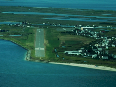
| TANGIER ISLAND TANGIER VA |
| |
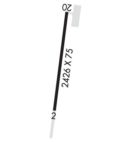
| Lat: N 3749.6 Long: W 07559.9 Elev: 5 Var: +11 Longest Runway: 2426 | ||
| AWOS: 119.8 CTAF: 122.8 | ||
| ||||||||||||||||||||||||||||||||
| ||||||||||||||||||||||||||||||||
| ||||||||||||||||||||||||||||||||
| Rwy | Rwy | |||||||
| 2426x75 | 2426' | 2426x75 | 2243' | |||||
| Runway ID | Single Wheel | Double Wheel | Double Tandem Wheel | Dual Double Wheel |
| 02/20 | 12,500 | N/A | N/A | N/A |
| These numbers are Advisory and are not limits. The Airport Manager should have more accurate Weight Limits | ||||
 Airport Diagram might not be current. | |
| Facility Name: | TANGIER ISLAND |
| City Name: | TANGIER |
| County: | ACCOMACK |
| State abbrev: | VA |
| State Name: | VIRGINIA |
| Ownership: | PUBLICLY OWNED |
| Use: | OPEN TO THE PUBLIC |
| Owner's Name: | TOWN OF TANGIER |
| Address: | TANGIER ISLAND |
| TANGIER, VA 23440 | |
| Owner's Phone: | 757-891-2496; TOWN OFFICE (757) 891-2438. |
| Manager's Name: | LAURIE THOMAS |
| Address: | PO BOX 244 |
| TANGIER, VA 23440 | |
| Phone: | 757-891-2496 |
| FAA Region: | EASTERN |
| FAA Field Office: | DCA |
| Date | Sunrise | Sunset |
|---|---|---|
| 04/25/24 Thursday | 6:15 | 19:50 |
| 04/26/24 Friday | 6:13 | 19:51 |
| 04/27/24 Saturday | 6:12 | 19:52 |
| 04/28/24 Sunday | 6:11 | 19:52 |
| 04/29/24 Monday | 6:10 | 19:53 |
| 04/30/24 Tuesday | 6:08 | 19:54 |
| 05/01/24 Wednesday | 6:07 | 19:55 |
| 05/02/24 Thursday | 6:06 | 19:56 |
| 05/03/24 Friday | 6:05 | 19:57 |
| 05/04/24 Saturday | 6:04 | 19:58 |
| 05/05/24 Sunday | 6:03 | 19:59 |
| 05/06/24 Monday | 6:02 | 20:00 |
| 05/07/24 Tuesday | 6:01 | 20:01 |
| 05/08/24 Wednesday | 6:00 | 20:02 |
| Airport Attendance Schedule | APR-OCT SAT-SUN 0800-1630; ARPT CLSD SS-SR DLY. |
| Airport Status | OPERATIONAL (This Status can change at any time - please check NOTAMS) |
| Airport Lighting Schedule | |
| Airport Storage Available | Tie Downs |
| Extra Services Available | NONE |
| Wind Indicator | YES - (unlit) |
| Control Tower | NO |
| CTAF Frequency | 122.800 |
| Unicom Frequency | 122.800 |
| Rotating Beacon Color | WG; ARPT BCN OTS INDEFLY. |
| Segmented Circle | NO |
| Landing Fee | YES |
| Airport Inspected | STATE - performed by STATE AERONAUTICAL PERSONNEL |
| Inspection Date | 07/28/2020 |
| Type of Fuel Available | None |
| Airframe Repair Service | NONE |
| Power Plant Repair Service | NONE |
| Latitude | N3749.6 |
| Longitude | W07559.9 (ESTIMATED) |
| Arpt Elevation | 5ft (SURVEYED) |
| Magnetic Variation | 11W |
| 1 miles W | of TANGIER |
| Traffic Pattern Altitude | |
| Sectional Chart | WASHINGTON |
| Operations (Reported) | Yearly | Avg. Daily |
|---|---|---|
| General Aviation Transient | 473 | 1 |
| General Aviation Local | 0 | 0 |
| Air Taxi | 465 | 1 |
| Commerical | 0 | 0 |
| Commuter | 0 | 0 |
| Military | 62 | 0 |
| Aircraft based on Field | |
|---|---|
| General Aviation Singles | 0 |
| General Aviation Multi | 0 |
| Jet Aircraft | 0 |
| General Aviation Helicopters | 0 |
| Military Aircraft | 0 |
| Gliders | 0 |
| Ultralights | 0 |
| FSS on field | NO |
| FSS tie-in | LEESBURG |
| FSS Phone | 1-800-WX-BRIEF |
| Who issues Notams | DCA |
| Notam D service at airport | YES |
| ARTCC Name | WASHINGTON |
| Airport Certification | |
| Aircraft Rescue & Firefighting Index | None |
| Airport of Entry | No |
| Custom Landing Rights | No |
| Joint Civil/Military | No |
| Military Landing rights | YES |
| NATIONAL PLAN OF INTEGRATED AIRPORT SYSTEMS (NPIAS) |
| GRANT AGREEMENTS UNDER FAAP/ADAP/AIP |
| ADVANCE PLANNING AGREEMENT UNDER FAAP |
| ASSURANCES PURSUANT TO TITLE VI, CIVIL RIGHTS ACT OF 1964 |
| PAEW ADJACENT TO ALL RWYS, TWYS & RAMPS. |
| BE ALERT: RSTD AREA ONE MI WEST OF ARPT; HI-SPEED ACFT DROP BOMBS & FIRE LIVE AMMUNITION IN AREA. |
| LANDING/PARKING FEE TO HELP PAY FOR RECENT RWY REHAB. |
| FOR CD CTC PATUXENT APCH AT 301-342-3740, WHEN PATUXENT APCH IS CLSD CTC POTOMAC APCH AT 866-640-4124. |
Airport Communications & Frequencies:
| |||||||||||||||||||||||||
| Runway: 02 | Runway: 20 | ||
| Mag heading: | 18° | Mag heading: | 198° |
| Rwy Slope: | -.02% Down | Rwy Slope: | .02% Up |
| Approach: | Approach: | ||
| Pattern: | Right Traffic | Pattern: | Left Traffic |
| Markings: | BASIC | Markings: | BASIC |
| Marking Condition: | POOR; PREV RWY NRS VSB ON FORMER RWY PAVEMENT. CHEVRONS ON FORMER RWY PAVEMENT POOR. RWY CENTERLINE POOR. | Marking Condition: | POOR; TWY LEAD-IN LINES POOR. RWY CENTERLINE POOR. |
| Arresting Dev: | Arresting Dev: | ||
| Lat & Long: | N3749.4 W07559.9 | Lat. & Long.: | N3749.8 W07559.8 |
| Elev: | 5.4 ft. MSL | Elev: | 4.8 ft. MSL |
| TCH: | TCH: | ||
| Visual Glide Path: | Visual Glide Path: | ||
| Displaced Threshold: | No | Displaced Threshold: | 183 feet |
| Touchdown Zone: | YES | Touchdown Zone: | YES |
| Touchdown Elev.: | 5.4 feet | Touchdown Elev.: | 5.4 feet |
| Visual Glide Slope: | Visual Glide Slope: | ||
| RVR Equipment: | RVR Equipment: | ||
| RVV Equipment: | NO | RVV Equipment: | NO |
| Approach Lights: | Approach Lights: | ||
| REIL: | NO | REIL: | NO |
| Centerline Lights: | NO | Centerline Lights: | NO |
| Touchdown lights: | NO | Touchdown lights: | NO |
| Runway Category: | Runway with a Non-precision Approach | Runway Category: | Runway with a Visual Approach |
| Declared Distances: | Declared Distances: | ||
| Obstructions: | TREE | Obstructions: | ROAD |
| Marked: | NOT Marked/Lighted | Marked: | NOT Marked/Lighted |
| Clearance slope: | 25:1 | Clearance slope: | 3:1 |
| Obstruction height: | 7 feet AGL | Obstruction height: | 15 feet AGL |
| Dist. from runway: | 380 feet | Dist. from runway: | 249 feet |
| Centerline offset: | 56 left of centerline | Centerline offset: | |
| Comments: | Comments: |
Thanks for using FltPlan.com
all rights reserved © 1999-2024 by Flight Plan LLC