
| SPARTANBURG DOWNTOWN MEMORIAL SPARTANBURG SC |
| |
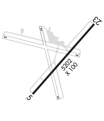
| Lat: N 3455.0 Long: W 08157.3 Elev: 802 Var: +05 Longest Runway: 5852 | ||
| Clr Del: 120.55 AWOS: 133.92 CTAF: 123.0 | ||
| ||||||||||||||||||||||||||||||||||||||||||||
| ||||||||||||||||||||||||||||||||||||||||||||
| ||||||||||||||||||||||||||||||||||||||||||||
| Rwy | Rwy | |||||||
| 5852x100 | 5852' | 109.10 - 046° | 5852x100 | 5852' | ||||
| Runway ID | Single Wheel | Double Wheel | Double Tandem Wheel | Dual Double Wheel |
| 05/23 | 95,000 | 131,000 | N/A | N/A |
| These numbers are Advisory and are not limits. The Airport Manager should have more accurate Weight Limits | ||||
 Airport Diagram might not be current. | |
| Facility Name: | SPARTANBURG DOWNTOWN MEML/SIMPSON FLD |
| City Name: | SPARTANBURG |
| County: | SPARTANBURG |
| State abbrev: | SC |
| State Name: | SOUTH CAROLINA |
| Ownership: | PUBLICLY OWNED |
| Use: | OPEN TO THE PUBLIC |
| Owner's Name: | CITY OF SPARTANBURG |
| Address: | PO DRAWER 1749 |
| SPARTANBURG, SC 29304 | |
| Owner's Phone: | 864-596-2000 |
| Manager's Name: | TERRY CONNORTON |
| Address: | 500 AMMONS RD |
| SPARTANBURG, SC 29306 | |
| Phone: | (864) 580-5004 |
| FAA Region: | SOUTHERN |
| FAA Field Office: | ATL |
| Date | Sunrise | Sunset |
|---|---|---|
| 04/24/24 Wednesday | 6:44 | 20:08 |
| 04/25/24 Thursday | 6:43 | 20:09 |
| 04/26/24 Friday | 6:42 | 20:10 |
| 04/27/24 Saturday | 6:41 | 20:11 |
| 04/28/24 Sunday | 6:40 | 20:11 |
| 04/29/24 Monday | 6:38 | 20:12 |
| 04/30/24 Tuesday | 6:37 | 20:13 |
| 05/01/24 Wednesday | 6:36 | 20:14 |
| 05/02/24 Thursday | 6:35 | 20:15 |
| 05/03/24 Friday | 6:34 | 20:15 |
| 05/04/24 Saturday | 6:33 | 20:16 |
| 05/05/24 Sunday | 6:32 | 20:17 |
| 05/06/24 Monday | 6:31 | 20:18 |
| 05/07/24 Tuesday | 6:30 | 20:19 |
| Airport Attendance Schedule | 7 Days A Week 0700-1900 |
| Airport Status | OPERATIONAL (This Status can change at any time - please check NOTAMS) |
| Airport Lighting Schedule | ACTVT MALSR RWY 05; REIL RWY 23; PAPI RWY 05 & 23; HIRL RWY 05/23 - CTAF. |
| Airport Storage Available | Tie Downs, Hanger |
| Extra Services Available | Glider, Flight Instruction, Aircraft Rental |
| Wind Indicator | YES - (lighted) |
| Control Tower | NO |
| CTAF Frequency | 123.000 |
| Unicom Frequency | 123.000 |
| Rotating Beacon Color | WG; ACTVT ROTATING BCN - CTAF. |
| Segmented Circle | YES |
| Landing Fee | NO |
| Airport Inspected | STATE - performed by STATE AERONAUTICAL PERSONNEL |
| Inspection Date | 08/31/2023 |
| Type of Fuel Available | Grade 100LL, JET A (freeze point -40C); -10FOR FUEL AFT HRS CALL 864-574-8552. |
| Airframe Repair Service | MAJOR |
| Power Plant Repair Service | MAJOR |
| Latitude | N3455.0 |
| Longitude | W08157.3 (ESTIMATED) |
| Arpt Elevation | 801ft (SURVEYED) |
| Magnetic Variation | 05W |
| 3 miles SW | of SPARTANBURG |
| Traffic Pattern Altitude | 800; TPA: 800 FT AGL FOR PISTON ACFT, 1300 FT AGL FOR TURBO PROP ACFT AND SML JETS. |
| Sectional Chart | CHARLOTTE |
| Operations (Reported) | Yearly | Avg. Daily |
|---|---|---|
| General Aviation Transient | 12649 | 35 |
| General Aviation Local | 14785 | 41 |
| Air Taxi | 5566 | 15 |
| Commerical | 0 | 0 |
| Commuter | 0 | 0 |
| Military | 390 | 1 |
| Aircraft based on Field | |
|---|---|
| General Aviation Singles | 55 |
| General Aviation Multi | 12 |
| Jet Aircraft | 3 |
| General Aviation Helicopters | 4 |
| Military Aircraft | 0 |
| Gliders | 5 |
| Ultralights | 0 |
| FSS on field | NO |
| FSS tie-in | ANDERSON |
| FSS Phone | 1-800-WX-BRIEF |
| Who issues Notams | SPA |
| Notam D service at airport | YES |
| ARTCC Name | ATLANTA |
| Airport Certification | |
| Aircraft Rescue & Firefighting Index | None |
| Airport of Entry | No |
| Custom Landing Rights | No |
| Joint Civil/Military | No |
| Military Landing rights | YES |
| NATIONAL PLAN OF INTEGRATED AIRPORT SYSTEMS (NPIAS) |
| GRANT AGREEMENTS UNDER FAAP/ADAP/AIP |
| SURPLUS PROPERTY AGREEMENT UNDER PUBLIC LAW 289 |
| ASSURANCES PURSUANT TO TITLE VI, CIVIL RIGHTS ACT OF 1964 |
| AGREEMENT UNDER DLAND OR DCLA HAS EXPIRED. |
| GLIDER OPS. |
| FOR CD IF UNA TO CTC ON FSS FREQ, CTC GREER APCH AT 864-877-8275, WHEN APCH CLSD CTC ATLANTA ARTCC AT 770-210-7692. |
Airport Communications & Frequencies:
| |||||||||||||||||||
| Runway: 05 | Runway: 23 | ||
| Mag heading: | 47° | Mag heading: | 227° |
| Rwy Slope: | -.13% Down | Rwy Slope: | .13% Up |
| Approach: | ILS/DME | Approach: | |
| Pattern: | Left Traffic | Pattern: | Left Traffic |
| Markings: | PRECISION INSTRUMENT | Markings: | PRECISION INSTRUMENT |
| Marking Condition: | GOOD | Marking Condition: | GOOD |
| Arresting Dev: | Arresting Dev: | ||
| Lat & Long: | N3454.6 W08157.7 | Lat. & Long.: | N3455.3 W08157.0 |
| Elev: | 794.5 ft. MSL | Elev: | 786.8 ft. MSL |
| TCH: | 45 ft. AGL | TCH: | 46 ft. AGL |
| Visual Glide Path: | 3.00 degrees | Visual Glide Path: | 3.00 degrees |
| Displaced Threshold: | No | Displaced Threshold: | No |
| Touchdown Zone: | YES | Touchdown Zone: | YES |
| Touchdown Elev.: | 801.9 feet | Touchdown Elev.: | 801.1 feet |
| Visual Glide Slope: | 4-Light PAPI on RIGHT side of Runway | Visual Glide Slope: | 4-Light PAPI on LEFT side of Runway |
| RVR Equipment: | RVR Equipment: | ||
| RVV Equipment: | NO | RVV Equipment: | NO |
| Approach Lights: | MALSR - 1,400 foot medium intensity approach lighting system with runway alignment indicator lights | Approach Lights: | |
| REIL: | NO | REIL: | YES |
| Centerline Lights: | NO | Centerline Lights: | NO |
| Touchdown lights: | NO | Touchdown lights: | NO |
| Runway Category: | Precision Instrument Runway | Runway Category: | D |
| Declared Distances: | TORA:5852' TODA:5852' ASDA:5852' LDA:5852' | Declared Distances: | TORA:5852' TODA:5852' ASDA:5452' LDA:5452' |
| Obstructions: | TREE | Obstructions: | |
| Marked: | NOT Marked/Lighted | Marked: | |
| Clearance slope: | 37:1 | Clearance slope: | 34:1 |
| Obstruction height: | 88 feet AGL | Obstruction height: | |
| Dist. from runway: | 3504 feet | Dist. from runway: | |
| Centerline offset: | 117 right of centerline | Centerline offset: | |
| Comments: | Comments: |
Thanks for using FltPlan.com
all rights reserved © 1999-2024 by Flight Plan LLC
